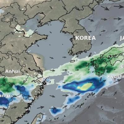
Articles

Thumbnail
The National Aeronautics and Space Administration (NASA), Science Mission Directorate, Earth Science Division has selected new projects from the 2018 Precipitation Measurement Missions (PMM) Science Team focus area solicitation. PMM projects focus on investigations related to satellite observations of precipitation using measurements from, but not limited to, the Global Precipitation Measurement (GPM) Core Observatory, GPM mission constellation partner spacecraft, and the Tropical Rainfall Measuring Mission (TRMM). Specifically the PMM program supports three types of investigations: (1) The
Thumbnail
a | b | c | d | e | f | g | h | i | j | k | l | m | n | o | p | q | r | s | t | u | v | w | x | y | z Click one of the letters above to advance the page to terms beginning with that letter. A active sensor search for term A remote-sensing sys­tem (e.g., an instrument) that transmits its own radiant energy to detect an object or area for observation and receives the reflected or transmitted energy. Radar is an example of an active system. Compare with passive sensor. algorithm search for term A self-contained step-by-step set of operations to be performed. Scientists use mathematical algorithms
IMERG rainfall totals from Japan, June 29 - July 5, 2020
This animation shows NASA IMERG rain rates (blue shading) and accumulations (green shading) near Kyushu island, in the southwest of Japan from June 29 - July 5, 2020. Devastating floods and landslides swept through parts of Kyushu on July 4, 2020, resulting in over 40 deaths and orders for hundreds of thousands of people to evacuate their homes according to media reports. Download video (right-click -> Save As) The rains that triggered the flooding occurred in the context of the Meiyu-Baiu rainy season, which arrives in east Asia every year from June to mid-July. “Meiyu” and “Baiu” are the
Farmer in a field in El Salvador
To reduce risks from natural disasters and build climate resilience, decision makers are using NASA Earth observations to develop index-based insurance products and protect low-income customers in Central America, especially in the region known as the Dry Corridor.
Hurricane Forecasting Screenshot
The powerful hurricane that struck Galveston, Texas on September 8, 1900, killing an estimated 8,000 people and destroying more than 3,600 buildings, took the coastal city by surprise. This video looks at advances in hurricane forecasting in the 120 years since, with a focus on the contributions from weather satellites. This satellite technology has allowed us to track hurricanes – their location, movement and intensity. “One of the dramatic impacts is that satellite data keeps an eye on the target," especially over unpopulated areas such as oceans, said JPSS Director Greg Mandt. “We’re sort...