Bermuda

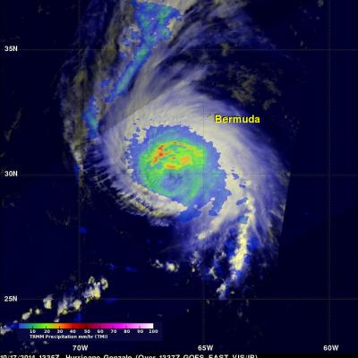
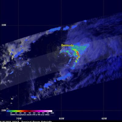
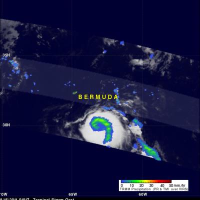
Hurricane Nicole Lashes Bermuda

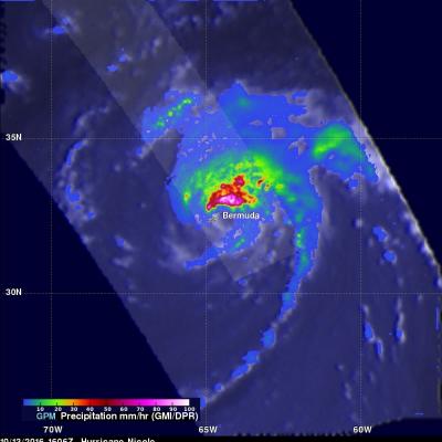
While powerful Hurricane Matthew drew a lot of attention as it made its way through the northern Caribbean and the Bahamas before ravaging the US East Coast with strong winds and massive flooding, another storm was lurking nearby in the western Atlantic--Nicole. Nicole, which like Matthew, also originated from a tropical wave that made its way across the central Atlantic from the coast of Africa. Nicole first became a tropical storm on the morning of the 4th of October about 525 miles northeast of San Juan Puerto Rico just after Matthew, a powerful Category 4 storm at the time, had devastated

Powerful Hurricane Gonzalo Menacing Bermuda

Hurricane Gonzalo formed south-southeast of Puerto Rico on October 12, 2014 and was upgraded to a hurricane the following day. Gonzalo became increasingly more powerful and was a weakening category four hurricane on the Saffir-Simpson hurricane intensity scale with sustained winds of about 115 kts (132 mph) when viewed by the TRMM satellite on October 17,2014 at 1335 UTC (10:35 AM ADT). A rainfall analysis from TRMM's Microwave Imager (TMI) is shown here blended with a GOES-EAST visible/infrared image received a few minutes later at 1337 UTC(10:33 AM ADT). A large area of heavy rainfall was
GPM Flies Over Hurricane Gonzalo
Download in Hi-Res from the Scientific Visualization Studio On October 16th, 2014 (1342 UTC) the Global Precipitation Measurement (GPM) mission's Core Observatory flew over Hurricane Gonzalo as it headed towards Bermuda. Hurricane Gonzalo remains a category 4 hurricane on the Saffir-Simpson Hurricane Scale, with maximum sustained winds at 130 mph. As of 12:00 UTC (8:00a.m. EDT) on Friday, October 17th, the National Hurricane Center forecast located the storm about 195 miles south southwest of Bermuda, where a hurricane warning is in effect. The GPM Core Observatory carries two instruments that...

Cristobal Passes Northwest Of Bermuda

The TRMM satellite had a very good view of Cristobal on August 28, 2014 at 1258 UTC (8:58 EDT) as the hurricane passed well to the northwest of Bermuda. Rainfall derived from TRMM's Microwave Imager (TMI) and Precipitation Radar (PR) data is shown overlaid on a 1300 UTC GOES-EAST Visible/Infrared image. TRMM PR found some intense thunderstorms producing rain at a rate of almost 78 mm (about 3.1 inches) per hour in a band of precipitation feeding into Cristobal's southeastern side. The next image is a simulated 3-D view (from the west) of Cristobal's rainfall structure using radar reflectivity

Gabrielle Seen Knocking On Bermuda's Door

Tropical storm Gabrielle was at a distance of about 50km (~31 miles) to the south-southwest of Bermuda on September 11, 2013 at 0041 (September 10, 2013 8:41 PM EDT) when the TRMM satellite flew above. A rainfall analysis from TRMM's Microwave Imager (TMI) and Precipitation Radar (PR) is shown overlaid on an enhanced infrared image from the satellite's Visible and InfraRed Scanner (VIRS). A band of light to moderate rainfall extends to Bermuda from a large area of heavy rainfall in the eastern side of Gabrielle. A red tropical storm symbol shows the surface location of tropical storm Gabrielle

TRMM Sees Gabrielle Closing In On Bermuda

The TRMM satellite flew directly above tropical storm Gabrielle on September 10, 2013 at 2124 UTC (5:24 PM EDT) as the storm approached Bermuda. TRMM's Precipitation Radar (PR) data found that rain was falling at a rate of over 127mm/hr (~5 inches) in a line of intense storms southeast of Bermuda. TRMM PR also found that the tallest thunderstorms, reaching to heights above 15.5km (~9.6 miles), were located in an area close to Gabrielle's center of circulation. Click here to see a simulated 3-D (Quicktime) flyby animation over Gabrielle approaching Bermuda using TRMM PR data. Click here to see

Debby's Remnants Will Slightly Affect Bermuda

The remnant low pressure center from tropical storm Debby is predicted to kick up winds to gale force and cause a few showers today as it passes to the northwest of Bermuda. The TRMM satellite passed over the low early this morning at 0717 (4:17 AM ADT). TRMM Microwave Imager (TMI) and Precipitation Radar (PR) data show that Debby's remnant low contained a few light to moderate showers. A 3-D view using TRMM PR data shows that the most powerful of these storms were only reaching heights of about 10km (~6.2 miles).

TRMM PR Slices Through Sean

The TRMM satellite had a good look at tropical storm Sean when it flew over on 10 November 2011 at 0541 UTC (00:41 AM EST). TRMM's Precipitation Radar (PR) data were used in the image above to show a 3-D cross section through Sean. TRMM's PR revealed that heights of storms in the edge of Sean's center of circulation were reaching to about 11km (~6.8 miles). Radar Reflectivity values of up to 46.0 dBZ found in these storms also showed that rainfall was heavy in that area. The "top down" satellite view above shows that those storms in Sean's northwestern quadrant were the most powerful. The rest

Maria Moving to the West of Bermuda

The TRMM satellite traveled above tropical storm Maria on Thursday 15 September 2011 at 1001 UTC ( 6:01 AM EDT). Maria's organization had improved over that seen by TRMM earlier in the week due to favorable (warmer) sea surface temperatures and lower upper level wind shear. A rainfall analysis from TRMM's Precipitation Radar (PR), displayed in a lighter swath, shows that powerful convective storms were dropping rainfall at a rate of over 50mm/hr (~2 inches) northwest of Maria's center of circulation. A large area of rainfall containing bands of heavier rainfall was also shown by TRMM's

Tropical Storm Gert

Tropical Storm Gert became the seventh named tropical cyclone in the Atlantic Ocean basin on Sunday August 14, 2011 at 1800 UTC ( 2 PM EDT). Gert was located southeast of Bermuda and appeared small but well organized when the TRMM satellite flew over on 15 August 2011 at 0101 UTC. A rainfall analysis from TRMM's Microwave Imager (TMI) shows a comma shaped area of moderate to heavy rainfall wrapping around the center of the small storm. The National Hurricane Center (NHC) expects Gert to intensify slightly while passing just to the east of Bermuda. Click here to see earlier TRMM information