China

GPM Examines Weaker Tropical Storm Yutu in the South China Sea

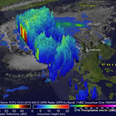
Typhoon YUTU (known as Rosita in the Philippines) is now threatening the Philippine Island of Luzon. On October 24, 2018 YUTU devastated the northern Mariana Islands of Tinian and Saipan as a super typhoon. One death has been attributed to the typhoon in the Marianas with many structures including schools and hospitals being destroyed. Typhoon YUTU weakened as it moved toward the Philippines and had maximum sustained winds of about 90 kts (103.5 mph) when the GPM core observatory satellite passed above the Philippine Sea on October 29, 2018 at 0212 UTC. This rainfall analysis was developed

GPM's GMI Measures Weakening Kong-Rey's Rainfall

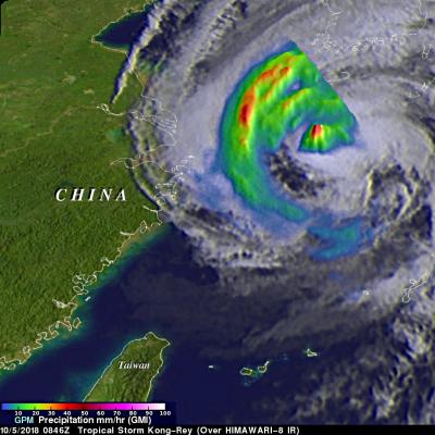
The GPM core observatory passed above tropical storm Kong-Rey on October 5, 2018 at 0846 UTC. Kong-Rey was a powerful category five typhoon just a few days ago but increased vertical wind shear and cooler sea surface temperatures have caused the tropical cyclone to weaken dramatically. Tropical storm Kong-Rey had maximum sustained winds of about 55 kts (63 mph) when it was scanned by the satellite. GPM's Microwave Imager (GMI) data were used to gauge the intensity of precipitation around Kong-Rey's center of circulation. Energy observed through clouds by GMI's microwave channels was used to

GPM Views Intensifying Tropical Storm Nanmadol

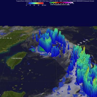
The GPM core observatory satellite flew above tropical storm NANMADOL on July 2, 2017 at 2306 UTC. The intensifying tropical storm was located just northeast of Taiwan and had maximum winds estimated at 45 kts (51.8 mph). The GPM Core Observatory carries the first space-borne Ku/Ka-band Dual-frequency Precipitation Radar (DPR) and a multi-channel GPM Microwave Imager (GMI). Rainfall within NANMADOL was derived from data collected by GPM's GMI and DPR instruments. Those data indicated that rain was falling at a rate of greater that 184 mm (7.2 inches) per in powerful storms northeast of the

Typhoon Haima Hits China After Devastating The Northern Philippines

After Haima's caused extensive destruction and at least 13 deaths in the northern Philippines the typhoon traveled across the South China Sea to batter Hong Kong and mainland China. Heavy rain and gusty winds accompanied Haima as the typhoon passed to the east of Hong Kong. Operations at Hong Kong's international airport were nearly stopped by the typhoon. At least one person was reported killed in Hong Kong. Haima made landfall in China 110 km (68 miles) east of Hong Kong at about 0400 UTC (noon CST). Haima's winds were decreasing and the typhoon was the equivalent of a category one hurricane

Another Typhoon Headed Toward Taiwan And China

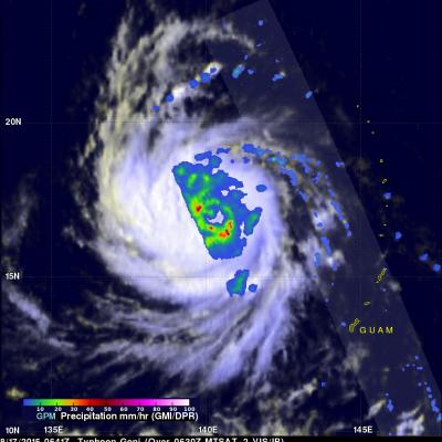
Last week deadly typhoon Soudelor caused at least 22 deaths in Taiwan and China. The GPM core observatory satellite recently had two good views of intensifying typhoon Goni that formed on August 14, 2015 in the same area of the Pacific Ocean as typhoon Soudelor. Typhoon Goni is forecast by the Joint Typhoon Warning Center (JTWC) to become a very powerful typhoon in the next week while moving along a track similar to typhoon Soudelor. Typhoon Goni could affect the same areas of the western Pacific Ocean. The first image shows a GPM satellite pass over Goni when the tropical cyclone was moving

Deadly Typhoon Soudelor's Rainfall Analyzed

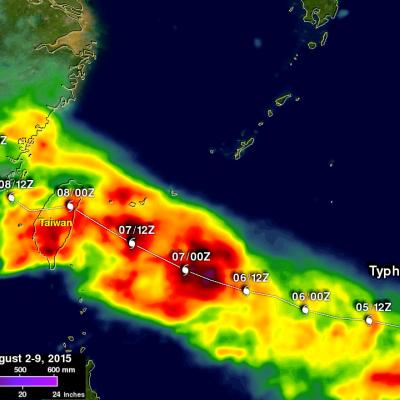
Soudelor formed in the middle of the Pacific Ocean well east of Guam on July 20, 2015. Soudelor became more powerful with peak intensity of about 155 kts (178 mph) reached on August 3, 2015 when the super typhoon was well east of Taiwan over the open waters of the Pacific Ocean. Soudelor's winds died down a little but rebounded to with over 100 kts (115 mph) before hitting Taiwan . Although Soudler was still a powerful typhoon when it hit land most deaths and destruction were caused by flooding and mudslides from heavy rainfall not from strong winds. The rugged terrain over typhoon amplified

GPM Has Another Good Look At Soudelor

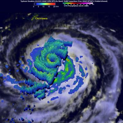
Typhoon Soudelor's winds had dropped to 95 kts ( 109 mph) when the GPM core observatory satellite had another excellent daytime view on August 6, 2015 at 0006 UTC. GPM's Dual-Frequency Precipitation Radar (DPR) data showed that Soudelor had heavy rainfall in an inner eye wall and also in a much larger replacement outer eye wall. The heaviest rain found by GPM was dropping at a rate of close to 70 mm (2.4 inches) per hour in a strong feeder band spiraling in on the southwestern side of the typhoon. Radar reflectivity data from GPM's Dual-Frequency Precipitation Radar (DPR) data were also used

Typhoon Soudelor Threatens Taiwan And China

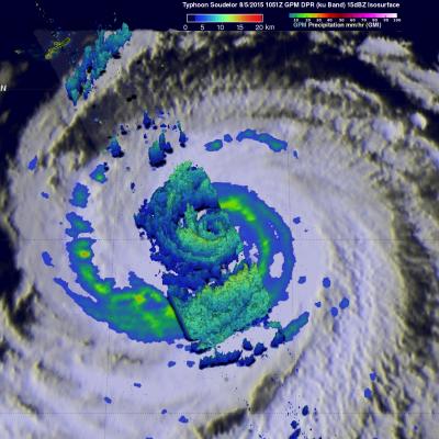
Typhoon Soudelor's sustained winds were about 105 kts ( about 121 mph) when the GPM core observatory satellite flew above on August 5, 2015 at 1051 UTC. A rainfall analysis was made from data collected from GPM's Microwave Imager (GMI) and Dual-Frequency Precipitation Radar (DPR) instruments. This analysis showed that Soudelor was very large and had a well defined eye. Intense feeder bands are shown spiraling into the center. Three dimensional radar reflectivity data GPM's DPR (ku Band) were used to construct a simulated cross section through typhoon Soudelor's center. This view from the south

Super Typhoon Soudelor Threatens Taiwan And China

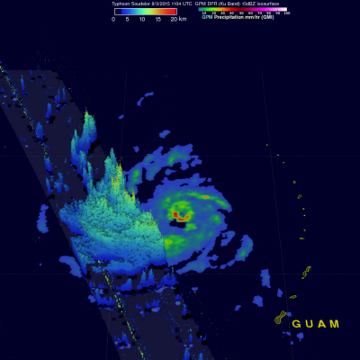
The GPM core observatory satellite flew almost directly over super typhoon Soudelor in the western Pacific Ocean on August 3, 2015 at 1104 UTC. At that time Super Typhoon Soudelor had winds of about 125kts (139 mph) and is predicted by the Joint Typhoon Warning Center (JTWC) to become even more powerful tomorrow while headed toward northern Taiwan. GPM's Microwave Imager (GMI) had a very good view of heavy rainfall associated with Soudelor. GMI showed that the super typhoon had rain falling at a rate of over 58 mm (2.3 inches) per hour in the southern side of Soudelor's well defined eye. Radar

Typhoon Matmo Drenches Taiwan

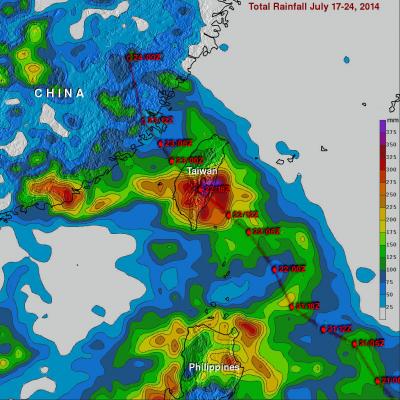
Typhoon Matmo hit eastern Taiwan at it's peak power with winds estimated at 85kts (about 98 mph). In addition to damaging winds Matmo produced very heavy rainfall while passing over central Taiwan. The TRMM-based, near-real time Multi-satellite Precipitation Analysis (TMPA) at the NASA Goddard Space Flight Center was used in this analysis to show rainfall totals for the period from July 17-24, 2014. It shows that rainfall totals greater than 400 mm (about 15.7 inches) soaked eastern Taiwan. Heavy rainfall also occurred yesterday over the Taiwan Strait. This band of heavy rainfall associated