Hawaii

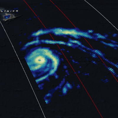
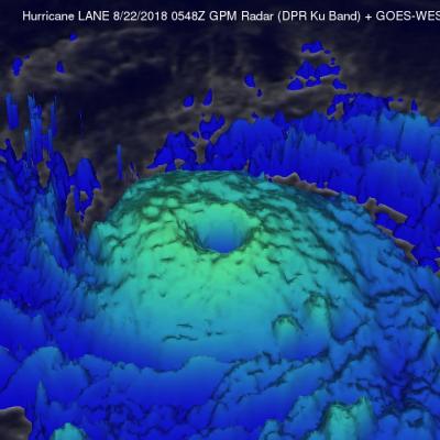
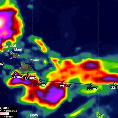
GPM Captures Cat. 4 Hurricane Lane Passing Close to Hawaiian Islands

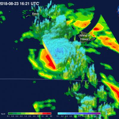
View Fullscreen in STORM Event Viewer Battling increased vertical shear, Hurricane Lane struggles northward, down from its Category 5 peak but still featuring winds of over 110 knots. The storm has already begun impacting the Hawaiian Islands, bringing over a foot of rain to Hilo via its outer bands. Lane is expected to continue northward, approaching the island chain, before slowly veering westward as it continues to lose strength. This weakening will not diminish its likely primary impacts, which will be intense coastal erosion and damage and torrential rainfall, upwards of 30 inches in some

GPM Views Hurricane Lane Approaching Hawaii

View Fullscreen in STORM Event Viewer Direct strikes on Hawaii by tropical cyclones are relatively rare, but Hurricane Lane is poised to buck that trend if the models are to be believed. At the time of this overflight, Lane had maximum sustained winds of 130 knots and featured a symmetrical eye in the GMI data with intense precipitation rates on both east and west sides of the tight circulation. Its impacts are likely to start with flooding, especially on the island of Hawaii. High surf and strong winds will also have an impact, although the locations of maximum intensity will be determined by

GPM Sees Hurricane Lane Threatening Hawaiian Islands With Heavy Rainfall

The GPM core observatory satellite flew over hurricane LANE on August 21, 2018 at 7:48 PM PST (August 22, 2018 at 0548 UTC). At that time LANE was located about 316 nautical miles (585.2 km) from Hilo, Hawaii. Hurricane LANE is one of the strongest tropical cyclones to move into the Hawaiian Islands. At the time of this GPM pass LANE was a category five on the Saffir-Simpson hurricane wind scale with winds of about 140 kts (161 mph). This analysis shows precipitation derived from data collected by the GPM satellite's Microwave Imager (GMI) and Dual-Frequency Precipitation Radar (DPR)

GPM Data Used to Evaluate Hawaii's Flooding Rainfall

A low pressure trough moving slowly westward through the northwestern Hawaiian Islands caused destructive flooding and mudslides over the past weekend. The trough disrupted the normal northeast trade winds flow north of Oahu on April 12, 2018. This caused extremely heavy rainfall as the trough deepened and moved very slowly over Kauai during the weekend. The 28.1 inches (713 mm) of rain reported in Hanalei within a 24 hour period was close to a record for the small town on Kauai's northern coast. Almost 32.4 inches (822 mm) of rain was reported during the same period over Wainiha, Kauai

GPM Measures The Altitudes of Hawaii's Rain And Snow

The mountains of Mauna Kea and Mauna Loa in the Hawaiian Islands have recently received heavy snowfall. Hawaii's balmy temperatures normally reach above 80 degrees Fahrenheit (27 C) at sea level on beaches such as Oahu's Waikiki but temperatures fall below freezing at the altitudes of tall mountain peaks on the Big Island. At 13,802 feet (4.2 km) Mauna Kea is Hawaii's tallest mountain. Snowfall is frequently seen on Mauna Kea's peak. The nature of precipitation in the Hawaiian Islands was recently examined using data collected by the GPM core observatory satellite. GPM flew over the Hawaiian

IMERG Shows Darby's Rainfall Over The Hawaiian Islands

Most of the Hawaiian Islands were spared serious damage from tropical storm Darby. The location of Darby's track through the Hawaiian Islands resulted in the islands of Hawaii and Oahu being the most affected. Flash flooding was common on Oahu due to a reported 177.8 mm (7 inches) of rain drenching the island. Interstate H-1 was flooded in some locations. Lightning damage was reported in Kaneohe on the windward side of Oahu. Estimates of rainfall accompanying tropical storm Darby were produced using NASA's Integrated Multi-satellitE Retrievals for GPM (IMERG) data. These IMERG rainfall

Tropical Storm Darby Brings Occasionally Heavy Rain To The Hawaiian Islands

Tropical storm Darby has caused some heavy rainfall in the Hawaiian Islands since hitting the big island (Hawaii) on Saturday July 23, 2016. After hitting the big island Darby passed to the south of Molokai and Maui. Rain falling at a rate of 25.4 mm (1 inch) to 50.8 mm (2 inches) per hour was reported on the island of Oahu as Darby passed to the southwest of the island. The National Weather Service office in Honolulu reported that parts of Interstate H-1 that serves the southern side of Oahu was closed due to flooding on Sunday night. Darby is affecting northern Kaui today. The GPM core

Ignacio Expected To Pass Near Hawaii

Hurricane Ignacio is the latest tropical cyclone in this busy 2015 eastern Pacific hurricane season to pose potential danger for the Hawaiian Islands. Guillermo passed close to the north, Hilda curved to the south and Kilo's course was threatening before a course change moved it to the south of the islands. The Central Pacific Hurricane Center in Honolulu Hawaii predicts that Ignacio will still be a hurricane when it passes to the northeast of Hawaii in about five days. Rainfall associated with hurricane Ignacio was measured by the GPM core observatory satellite's Microwave Imager (GMI) on

Hurricane Loke Viewed By GPM

This year the Eastern Pacific Ocean continues to spawn significant tropical cyclones. Hurricane Loke formed southwest of the Hawaiian Islands on August 21, 2015 but Loke has not been a threat to Hawaii because it intensified to hurricane strength while moving well west of Hawaii over the open waters of the Pacific Ocean. The GPM core observatory satellite measured precipitation within the hurricane as it flew above the most powerful storms in the hurricane on August 2015 at 0116 UTC. GPM's Dual-Frequency Precipitation Radar (DPR) measured rain falling at over 160 mm (6.3 inches) per hour in

GPM Sees Energetic Tropical Depression Kilo

Rainfall associated with tropical depression Kilo recently dumped heavy rain in some areas of the state of Hawaii. Tropical depression Kilo changed course to move away from the Hawaiian Islands so it is no longer a threat but has recently been more energetic. The GPM core observatory satellite flew over on August 25, 2015 at 0121 UTC as Kilo approached Johnson Atoll and found that rainfall intensity had recently increased and the tropical depression's storm tops were very tall. GPM's Dual-Frequency Precipitation Radar (DPR) discovered that rain was falling at a rate of almost 65 mm (2.6 inches