Hawaii

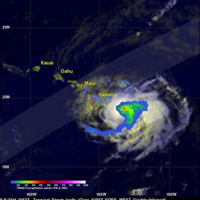
Tropical Depression Kilo May Be A Problem For Hawaii

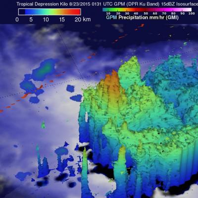
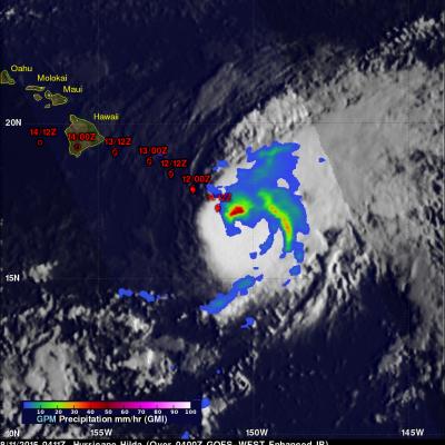
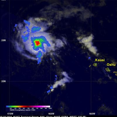
A tropical depression labeled Kilo formed to the southeast of the Hawaiian Islands on August 20, 2015. The tropical cyclone has moved to the southwest of the Islands. The Central Pacific Hurricane Center (CPHC) predicts that Kilo will strengthen into a hurricane as it moves in the general direction of the island of Kauai over the next five days. The GPM core observatory satellite measured the rainfall near Kilo on August 23, 2015 at 0131 UTC. GPM’s Microwave Imager (GMI) and GPM's Dual-Frequency Precipitation Radar (DPR) discovered that rain was falling at a rate of over 121 mm (4.8 inches)

Hurricane Hilda Weakening, Heads Toward Hawaii

Three days ago Hilda was a category four hurricane on the Saffir-Simpson Hurricane Wind Scale with winds of 120 kts (138 mph). Hilda has been weakening and had winds of about 80 kts (92 mph) when the GPM core observatory satellite passed above on August 11, 2015 at 0411 UTC (August 10, 2015 at 6:11 PM HST). Rainfall data from GPM's Microwave Imager (GMI) instrument is shown overlaid on a 0400 UTC August 11, 2015 GOES-WEST Infrared image. GPM's GMI revealed that storms north of hurricane Hilda's eye were dropping rain at a rate of over 53.6 mm (2.2 inches) per hour. Hilda's future positions

Weakening Hurricane Guillermo Nears Hawaiian Islands

Hurricane Guillermo was a category one hurricane with wind speeds of about 75 kts (86 mph) when the GPM core observatory satellite flew over on Sunday August 2, 2015 at 1901 UTC. Rainfall was measured by GPM's Microwave Imager (GMI) and Dual-Frequency Precipitation Radar (DPR) instruments falling at a rate of over 61 mm (2.4 inches) per hour northeast of Guillermo's eye. GPM's DPR found rain falling at a rate of over 91 mm (3.6 inches) per hour in a feeder band spiraling into Guillermo from the southeast. GPM radar reflectivity data (Ku band) were used to show a 3-D cross section through the

Hurricane Guillermo Heads Toward Hawaii

On July 29, 2015 tropical depression Nine-E formed in the eastern Pacific Ocean well southwest of the southern tip of Baja California. The tropical depression was in an area of warm ocean water which helped the tropical cyclone blossom into tropical storm Guillermo early on July 30, 2015. Guillermo is a hurricane today and is headed over the open waters of the Pacific Ocean toward the west-northwest. In about a week Guillermo may affect the Hawaiian Islands as a tropical storm. On July 31, 2015 at 0556 UTC Guillermo was about 319 km (~590 Nautical Miles) east-southeast of Hilo, Hawaii when the

Tropical Storm Ela To Pass Near Hawaiian Islands

A tropical storm called Ela formed east-southeast of the Hawaiian Islands on July 8, 2015 and is expected to pass to the north of the island chain this weekend. GPM had a good view of Ela as the satellite flew over the forming tropical storm on July 8, 2015 at 1316 UTC (3:16 AM HST). The satellite passed above Ela again on July 9, 2015 at 0234 UTC (July 8, 2015 4:34 PM HST) showing that rainfall bands associated with the tropical cyclone were better organized. GPM's Microwave Imager (GMI) and Dual-Frequency Precipitation Radar (DPR) instruments found today that rainfall was falling at a rate

Tropical Storm Ana Still Vigorous

The TRMM satellite flew over tropical storm ANA on October 22, 2014 at 1935 UTC (about 8:30 AM local time). ANA formed over ten days ago but after moving to the northwest of the Hawaiian islands the tropical storm was shown to be still vigorous. A rainfall analysis from TRMM's Microwave Imager (TMI) revealed an area near ANA's center of circulation where rain was falling at a rate of over 40 mm (about 1.6 inches) per hour. The Joint Typhoon Warning Center (JTWC) predicts that ANA will maintain tropical storm intensity for the next five days while moving over open waters toward the northwest.

Hurricane Ana Bypasses But Soaks Hawaiian Islands

Fortunately for Hawaii hurricane Ana passed to the south of the islands. This meant that for the third time this year the Hawaiian Islands were spared destructive hurricane force winds. However, Ana caused occasionally heavy rain over much of the area and was responsible for flash floods on the the big island (Hawaii). This analysis shows estimated rainfall totals during the period when hurricane Ana formed on October 13, 2014 and moved west of the Hawaiian Islands on October 21, 2014. The TRMM-based, near-real time Multi-satellite Precipitation data (TMPA) analysis is used to monitor rainfall

Ana Threatens Hawaiian Islands

Tropical storm Ana, that formed southeast of the Hawaiian islands on October 13, 2014, will be the third tropical cyclone to threaten the island chain this year. Hurricane Iselle weakened to a tropical storm and passed over the island of Hawaii on August 8, 2014. Hurricane Julio was still a hurricane when it veered to the northeast of the islands on August 10, 2014. Tropical storm Ana was recently seen by the TRMM satellite on October 16, 2014 at 2224 UTC and October 17, 2014 at 1313 UTC. Rainfall from these two orbits are shown overlaid on GOES-WEST visible and infrared images received on the

Tropical Storm Iselle Departs Hawaii While Julio Stays Well North

Iselle was once a rather powerful category 4 hurricane in the East Pacific with sustained winds estimated at 120 knots (~138 mph) by the National Hurricane Center. Fortunately, a combination of southwesterly wind shear, drier air and cooler waters weakened Iselle considerably as it approached the Hawaiian Islands. Although much weaker, Iselle still struck the southeast Kau coast of the Big Island of Hawaii as a rather strong tropical storm. In fact Iselle, was the strongest and only the 2nd tropical storm to hit the Big Island in over 50 years. The center made landfall around 2:30 am HST

Tropical Storm Iselle Hits Hawaii

Hurricane Iselle weakened to a tropical storm while approaching the island of Hawaii on Thursday August 7, 2014. As a tropical storm Iselle contained some heavy rain showers and strong winds when it hit the big island. Iselle later dropped some heavy rain over Maui and scattered showers extended to Kauai and Oahu. The TRMM satellite had an excellent view of tropical storm Iselle as it neared the Hawaiian islands on August 8, 2014 at 0152 UTC ( August 7 at 3:52 PM HST). A rainfall analysis from TRMM's Microwave Imager (TMI) and Precipitation Radar (PR) instruments is shown overlaid on a 0200