IMERG

GPM IMERG Sees Flooding in France

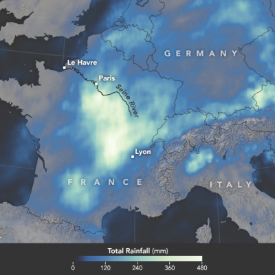
In June 2016, a slow-moving weather system unleashed several days of heavy downpours on western Europe, pushing the Seine River to heights not seen in 34 years. With the Seine’s water levels 6.1 meters (20 feet) above normal in Paris, flood waters knocked out electricity for thousands of people, interrupted road and rail traffic, shut down schools, and caused an estimated 1 billion euros of damage. During the worst of the flooding, the world’s most visited museum, the Louvre, closed as employees scrambled to move artwork out of basement areas that were at risk of flooding. The map above
A Global Tour of Precipitation from NASA
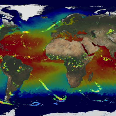
Credits: NASA/Goddard This video and related visualizations are public domain and can be downloaded at the Scientific Visualization Studio Precipitation (falling rain and snow) is our fresh water reservoir in the sky and is fundamental to life on Earth. A Global Tour of Precipitation from NASA shows how rain and snowfall moves around the world from the vantage of space using measurements from the Global Precipitation Measurement Core Observatory, or GPM . This is a joint mission between NASA and the Japanese Aerospace Exploration Agency (JAXA) and offers the most detailed and worldwide view of...

Recent IMERG Anomalies

Below are a few recent satellite anomalies of note that may have affected the quality of the IMERG precipitation products. 10 May 2016: The data flow from the Himawari-8 GEO satellite was interrupted for 57 hours, 7 May, 05 UTC – 9 May, 14 UTC and during that time there is a continuous zone of missing values in the IR precipitation data in the center of the Himawari-8 sector (over Japan), where data from the adjoining GEO satellites are unable to fill the gap. The IR-based displacement vectors were therefore computed using the standard fallback of spatial interpolation. 20 April 2016

GPM Measures Deadly Flooding Rainfall

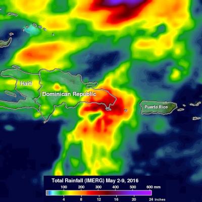
Over the past week extreme rainfall caused flooding that resulted in the deaths of four in Haiti and the evacuation of over 2500 people in the Dominican Republic. The GPM core observatory satellite saw a line of heavy rainfall on the eastern side of the Dominican Republic when it flew over on May 8, 2016 at 0428 UTC. GPM's Microwave Imager (GMI) and Dual-Frequency Precipitation Radar (DPR) instruments collected data that were used to estimate rainfall. This precipitation is shown on a top-down satellite view. Powerful storms were measured dropping rain at a rate of almost 300 mm (11.8 inches)

F17 SSMIS Data Processing Resumes

PPS will be restarting F17 processing. There will be 88 1C products that will be retracted and reprocessed for the following dates: 2016-04-13 (18:29:37) to 2016-04-19 (23:56:53). Starting from this date and forward all 1C F17 products will flag the 37V channel as bad data and the Brightness Temperatures will be missing. We apologize for any inconvenience or problems that this may cause and appreciate your understanding and patience. Please contact us if you have any questions or concerns.

IMERG Early/Late Run Precipitation Anomalies

Beginning on April 6, anomalies in the input SSMIS F17 precipitation estimates were detected in the IMERG Early and Late runs. These anomalies manifest as episodic “swath shaped” areas of high precipitation over land which appear to affect most orbits to some degree. The root cause is degradation in the 37 GHz V polarization channel. On April 13 the issue was somewhat mitigated but we continue to monitor the situation. Please let us know if you detect these (or other anomalies) in the IMERG Early and Late Runs after April 13.

Potential Upcoming Data Outages Due to Severe Winter Storm

The Washington, DC area is about to get hit with a record-level snow storm, with attendant disruptions to work schedules, travel, communications, and power. If you find that the TMPA-RT products drop out, it is safe to assume that some combination of these effects is preventing production, and we will work to restore service when that is possible.

Paraguay's Deadly Flooding Rainfall Measured By IMERG

Widespread flooding has recently affected tens of thousands of people in South America. Paraguay has been especially hard hit with the worst flooding in decades occurring after heavy summer rainfall. An estimated 90,000 people have been evacuated from their homes. Storms and flooding caused the deaths of at least six people in Asuncion, Paraguay. The analysis above was generated using the Integrated Multi-satellitE Retrievals for GPM (IMERG) data product. IMERG rainfall estimates are computed in near-realtime. IMERG data indicates that over 350 mm (13.8 inches) of rain fell northeast of

Northwest's Extreme Rainfall Checked By IMERG

During the past week moisture from the tropics has been pumped into the Pacific Northwest by the "Pineapple Express". Resulting extreme rainfall has led to widespread flooding and landslides. The continued "training" of rainfall into the area has caused flooding in the Portland, Oregon area with at least one death reported. Western Washington is also on flood alert due to the deluge. Rainfall that occurred during the past week (December 2-9, 2015) was measured with data from NASA's Integrated Multi-satellitE Retrievals for GPM (IMERG). IMERG found that many areas from northern California