Japan

Typhoon Hagibis Brings Heavy Rains to Japan
Typhoon Hagibis, a once powerful super typhoon, struck the main Japanese island of Honshu over the weekend, bringing very heavy rains and widespread flooding. Hagibis formed into a tropical storm on the 5th of October from a tropical depression that originated from a westward moving tropical wave north of the Marshall Islands. At first, Hagibis strengthened steadily becoming a typhoon about 24 hours after becoming a tropical storm. But, then on the 7th, Hagibis underwent a remarkable rapid intensification cycle and quickly intensified into a super typhoon with sustained winds estimated at 160 mph by the Joint Typhoon Warning Center (JTWC) less than 24 hours after becoming a minimal typhoon.

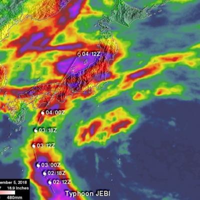
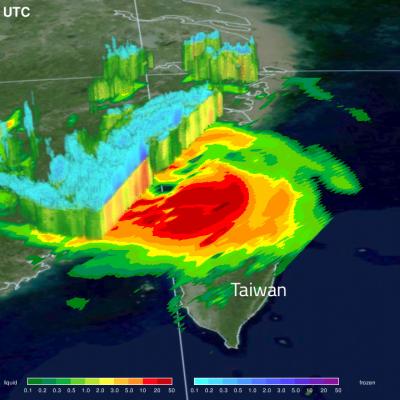
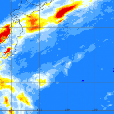
GPM Views Cat. 2 Typhoon Trami Moving Towards Japan

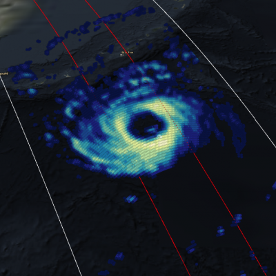
View fullscreen in STORM Event Viewer Once a Category 5 Super Typhoon, Trami has become rooted in place due to a lack of steering flow. This has caused the storm to deplete the warm waters beneath it and it has since weakened to a Category 2 with maximum winds of 90 knots. It maintains a broad eye and once it begins moving again, is likely to reintensify at least somewhat as it zooms northeastward over the Ryukyu Islands and into the southern coast of Japan. Wind impacts are likely to be exacerbated by its forward speed and current forecasts expect it to have widespread impacts in a region

GPM IMERG Adds Up Heavy Rains from Typhoon Jebi

Typhoon Jebi brought flooding to Japan and NASA’s IMERG estimated rainfall over the country and the surrounding region for a one-week period. The above image shows accumulated IMERG rainfall estimates over Japan and the surrounding region for the 1-week period from August 29 to Sept. 5, 2018 show rainfall amounts on the order of 100 mm (~4 inches, shown in red) or more covering much of the main island of Honshu and Shikoku in the south. Much of the band of rain oriented east-west across central Japan was due to a frontal system that brought rain to the area before Jebi made landfall. Super

GPM Sees Tropical Cyclone Jebi Threaten Japan

Japan has been afflicted by several tropical cyclones and other extreme weather this summer. The Joint Typhoon Warning Center (JTWC) predicts that yet another typhoon called JEBI will be approaching the main islands of Japan early next week. Warm ocean temperatures and low vertical wind shear are providing a favorable environment for JEBI's intensification. The JTWC predicts that the typhoon will have peak sustained winds of 115 kts (132 mph) as it moves over the northern Pacific Ocean toward Japan next week. The GPM core observatory satellite passed above on August 28, 2018 at 1816 UTC when

GPM Views "Truck-Tire" Eyewall of Typhoon Soulik

View Fullscreen in STORM Event Viewer Avoiding Kyushu, Typhoon Soulik instead barrelled toward the Northern Ryukyu islands, with the 'truck-tire' eyewall impacting Amami (in the south) and Yakushima (in the north) Islands in this overflight. It featured winds approaching 100 knots as it moved northwestward. Soulik is expected to recurve toward the western coast of Korea, where it is likely to have devastating impacts to the majority of the peninsula depending on its ability to maintain intensity.

GPM Flies Over Typhoon Jongdari Twice in Two Days

7/27/18 Having both deepened in central pressure and broadened in precipitation shield, Jongdari is steadily intensifying as it churns towards the southern coast of Japan. In this overflight, the storm has deep convection both near the eye itself and scattered throughout its outer bands, and its maximum sustained winds are approaching 90 knots. It is expected to further intensify over the next 24 hours, reaching Category 3 status before weakening slightly prior to making landfall south of Nagoya. Jongdari will bring heavy rains and strong winds to a heavily-populated region, including the

Typhoon Maria Makes Landfall

After striking the Ryukyu Islands of Japan and grazing Taiwan with torrential rains, Typhoon Maria made landfall just north of the populous city of Fuzhou, China with sustained winds of 95 knots and a broad shield of precipitation. The storm appears lopsided in the GMI, with much of the deep convection offshore, however, it is still likely to bring a brief period of flooding rains to this part of China before dissipating. View fullscreen in STORM Event Viewer

GPM IMERG Analyzes Rainfall from Powerful Typhoon Prapiroon

The image above shows estimates of accumulated rainfall using IMERG (Integrated Multi-satellitE Retrievals for GPM) data formed during the period from June 28-July 6, 2018. Typhoon PRAPIROON developed in the northwest pacific Ocean east-northeast of the Philippines on June 28, 2018. PRAPIROON became a typhoon on July 2nd as it approached the Korea Strait between Japan and Korea. Stormy weather had already produced heavy rainfall in Korea and Japan before typhoon PRAPIROON moved through the area. IMERG estimates indicated that PRAPIROON and other stormy weather dumped over 512 mm (20.2 inches)

GPM Observes Another Typhoon That May Threaten Japan

The GPM core observatory satellite passed above recently formed tropical storm Saola on October 24, 2017 at 0210 UTC. Tropical storm Saola was located west of Guam and was moving toward the northwest. Very heavy rainfall was measured by GPM's Microwave Imager (GMI) and Dual-Frequency Precipitation Radar (DPR) instruments in powerful convective storms to the southwest of Saola's center. GPM's radar (DPR Ku band) found that some storms in this cluster were dropping rain at a rate of greater than 252 mm (9.92 inches) per hour. This 3-D view of the powerful storms southwest of Paola's center of

GPM Examines Deadly Typhoon Lan

Typhoon Lan caused flooding, landslides and the death of at least seven people when it hit Japan early Monday morning. The powerful typhoon was accompanied by high winds and extremely heavy rainfall. Rain totals of 800 mm (31.5 inches) were reported in parts of south central Honshu. Wind speeds of over 106 kts (121.9 mph) were also reported. On October 22, 2017 at 0556 UTC the "core" satellite of the Global Precipitation Measurement (GPM) mission had an excellent view of Lan as the typhoon was approaching Japan. Data collected by GPM's Microwave Imager (GMI) and Dual-Frequency Precipitation