Philippines

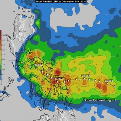
Powerful Typhoon Goni Brushing The Philippines

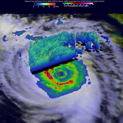
Rain bands from typhoon Goni were hitting the island of Luzon in the northern Philippines when the GPM core observatory satellite flew over on August 20, 2015 at 0711 UTC (3:11 PM Philippine Standard Time). GPM's Microwave Imager (GMI) clearly showed the intensity of rain falling in Goni's inner and replacement outer eye wall. GMI found that precipitation was falling at a rate of over 88.0 (3.5 inches) in extreme rainfall south of Goni's distinct eye. Radar reflectivity data from GPM's Dual-Frequency Precipitation Radar (DPR) instrument was used in this view (from the east) to show the 3-D

GPM Saw Deadly Maysak Approaching The Philippines

Typhoon Maysak caused the reported deaths five people in the Federated States of Micronesia and as a tropical storm killed seven others when it hit the the north-eastern Philippines. The GPM core observatory satellite passed above dissipating typhoon Maysak when it was approaching the Philippines on April 3, 2015 at 2326 UTC. An analysis of rainfall from GPM's Microwave Imager (GMI) showed that Maysak was dropping rain at a rate of over 69 mm (2.7 inches) per hour. Vertical wind shear was causing typhoon Maysak to weaken as it moved toward the Philippines but data from GPM's Dual-Frequency

Mekkhala Becomes A Typhoon, Drenches The Philippines

On January 16, 2015 tropical storm Mekkhala became the first western Pacific typhoon of the year just before hitting the eastern Philippines. This image shows rainfall derived from data captured by the GPM (core satellite) on January 16, 2015 at 2200 UTC. This was only about four hours after Mekkhala was upgraded to a typhoon. GPM's Microwave Imager (GMI) found rain falling at a rate of over 70.7 mm (about 2.8 inches) per hour in storms southwest of the typhoon's eye. Rainfall over the Philippines, enhanced by typhoon Mekkhala, was analyzed using near real time merged satellite data (3B42)

Two Satellites Measured Rainfall in Tropical Depression Mekkhala

The first tropical depression of the 2015 western Pacific season formed southwest of Guam on January 13 and is predicted to intensify into a tropical storm while headed toward the Philippines. NASA's TRMM and GPM satellites provided a look at Tropical Depression Mekkhala's rainfall data that showed the area of moderate rainfall had expanded as the storm strengthened on January 13. Mekkhala was previously known as Tropical Depression 01W until January 14 when it was renamed. Both the Global Precipitation Measurement (GPM) core satellite and the Tropical Rainfall Measuring Mission (TRMM)

Deadly Flooding and Landslides With Tropical Storm Jangmi

Jangmi became the 23rd named tropical cyclone in the western Pacific Ocean when it formed southeast of the Philippines on December 28, 2014. Heavy rainfall from Tropical storm Jangmi recently produced flooding and landslides in the Philippines that have reportedly killed over 30 people. The Philippines frequently gets hit by tropical cyclones. Tropical storm Jangmi hit only three weeks after slow moving typhoon Hagiput churned through the central Philippines. The TRMM satellite had a fairly good view of Jangmi on December 29, 2014 at 1425 UTC. The TRMM Microwave Imager(TMI) instrument showed

Deadly Super Typhoon Hagupit Moved Slowly

As of Today, super typhoon Hagupit has been deadly with up to 27 deaths reported but the Philippines has been spared the widespread destruction caused by Super typhoon Haiyan in 2013. Hagupit's (called Ruby in the Philippines) forward motion slowed on December 4, 2014 before reaching the Philippines. After hitting Samar in the eastern Philippines Hagupit's continued slow movement resulted in high rainfall amounts along the typhoon's track. These high rainfall totals meant that flooding occurred frequently along the typhoon's track. When the TRMM satellite flew over on December 8, 2014 at 0132

GPM Core Observatory Sees Hagupit's Eye

The GPM satellite flew almost directly above dangerous typhoon Hagupit on December 5, 2014 at 1032 UTC as the typhoon was approaching the Philippines. The GPM Microwave Imager (GMI) instrument measured rain falling at a rate of over 76 mm (almost 3 inches) per hour in the typhoon's eye wall. This 3-D view of Hagupit's precipitation structure was made using data from the Ku band on GPM's dual frequency radar instrument (DPR). DPR showed that some tall thunderstorm in Hagiput's eye wall were reaching heights of almost 15 km (about 9.3 miles). Click here to see a Low Resolution 640x360 simulated

Super Typhoon Hagupit Threatens Philippines

Super Typhoon Hagupit is threatening the Philippines a little over a year after deadly Super Typhoon Haiyan devastated the island nation in November 2013. Hagupit was weakening slightly from peak wind speeds of 155 kts (178 mph) when the GPM core observatory satellite passed over on December 4, 2014 at 2304 UTC in the image shown above. Hagupit had winds of about 125 kts (144 mph) when viewed by the TRMM satellite on December 5, 2014 at 0308 UTC in the image shown below. Rainfall data from these satellites are shown overlaid on daylight views from the MTSAT-2 satellite captured at close to the

Typhoon Rammasun Strikes The Philippines

Today typhoon Rammasun is pounding the Philippines with strong winds and heavy rainfall. Rammasun was labeled a tropical storm on July 12, 2014 when it formed west of Guam. Rammasun strengthened and was upgraded to a typhoon on July 14, 2014. Typhoon Rammasun became still more powerful and had winds estimated at 100kts (about 115 mph) today making it a category three tropical cyclone on the Saffir-Simpson hurricane wind scale. The images above show typhoon Rammasun as the TRMM satellite flew over on July 14, 2014 at 1819 UTC and again on July 15, 2014 at 0410 UTC. These images show that

Tropical Disturbance Adds Rain To Philippines

On April 21, 2014 at 2219 UTC the TRMM flew over stormy weather within a tropical disturbance near the Philippines. Precipitation from this tropical low adds to above normal rainfall for the Philippines during the past 30 days. Heavy rainfall with the slow moving remnants of tropical depression Peipah caused flooding in the Philippines earlier this month. TRMM's Precipitation Radar data were used to make a 3-D vertical slice through the tallest thunderstorm towers in this area of stormy weather. This slice shows that some storms were returning radar reflectivity values of greater than 52dBZ