tropical cyclones

TRMM Sees TD13 Forming

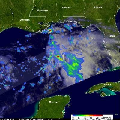
The TRMM satellite viewed the thirteenth tropical depression of the Atlantic hurricane season on Thursday 1 September 2011 at 1309 UTC (9:09 AM EDT) when it was still forming. The National Hurricane Center (NHC) has predicted that TD13 will intensify and become a tropical storm (Lee) today. The tropical storm is predicted by the NHC to slowly move toward the northwest and cause heavy rainfall over the states along the northern Gulf Of Mexico's coast. One area of heavy rainfall in the middle of the Gulf Of Mexico was in the center of the area viewed by TRMM's Precipitation Radar (PR). Some of
TRMM image of hurricane Irene intesifying as it nears the Bahamas
UPDATE: Monday, August 29th, 2011 Irene Drenches Northeastern United States UPDATE: Friday, August 26th, 2011 Irene Passes Through the Bahamas, Heads Towards Cape Hatterus Wednesday, August 24th, 2011 After becoming a small hurricane while passing over Puerto Rico, Irene re-emerged over the warm, open waters of the western Atlantic northwest of the Dominican Republic on the morning of August 22nd. The storm quickly showed signs of intensifying as deep convective towers arose near the center of Irene, releasing heat into the core of the system. In response, Irene's central pressure fell and...

Tropical Cyclone Forming in the Caribbean

On 18 August 2011 at 0307 UTC (11:07 PM EDT) the TRMM satellite traveled above an area of organized shower activity in the Caribbean Sea that the National Hurricane Center (NHC) forecasts will soon become a tropical cyclone. TRMM's Microwave Imager (TMI) and Precipitation Radar (PR) data show that this tropical wave south of Jamaica contained several areas of convective thunderstorms that were dropping rainfall at the rate of over 40 mm/hr (~1.6 inches). TRMM's PR data show that some thunderstorm towers in this stormy area were higher than 13 km (~8 miles).

TRMM Sees Tropical Cyclone Forming

The National Hurricane Center (NHC) has given an area of disturbed weather in the eastern Pacific Ocean a high probability (70%) of becoming a tropical cyclone. The TRMM satellite flew over this disturbance, located about 2,680km (~1,665 miles) east-southeastof the Hawaiian Islands, on 14 August 2011 at 2306 UTC. TRMM's Precipitation Radar (PR) revealed that numerous heavy thunderstorms in an area west of the low pressure center were dropping rain at the rate of over 50mm/hr (~2 inches). TRMM's PR also showed that a few thunderstorm towers near the center of the developing tropical cyclone

Another Tropical Cyclone Develops Near The Philippines

The sixth western Pacific tropical cyclone (06W) of 2011 has developed near the Philippines. Tropical storm AERE, super syphoon SONGDA and Tropical Storm SARIKA have already affected the Philippines this year. The TRMM satellite had an early morning look at the forming depression on 16 June 2011 at 2130 UTC. A precipitation analysis from TRMM's Microwave Imager (TMI) and Precipitation Radar (PR) shows that 06W wasn't well organized but contained areas of moderate to heavy rainfall located east of the Philippines. 06W is expected to intensify to a tropical storm, brush the northeastern coast of

Tropical Cyclones over Australia

TRMM-based, near-real time Multi-satellite Precipitation Analysis (TMPA), data were used in the analysis above to show rainfall contributed by tropical cyclones that have affected Australia in 2011. The tracks of tropical cyclones are shown with thin black lines. The largest tropical cyclone rainfall contribution was over the coast of northwestern Australia with estimated totals of over 600 Millimeters (~23.6 inches). Cyclones Bianca, Carlos, Twenty, Errol and their remnants were close enough to the northwestern coast of Australia to add to these rainfall totals. Cyclones Zelia, Anthony and

Tropical Cyclone Errol Near Australia

The South Indian Ocean tropical cyclone season is nearing it's end but another tropical cyclone called ERROL has developed northwest of Australia. The TRMM satellite flew over ERROL when it was getting organized on 14 April 2011 at 1732 UTC. The image on the left above shows an analysis of rainfall using data from TRMM's Microwave Imager (TMI) and Precipitation Radar (PR) instruments. The light swath shows the locations of some heavy thunderstorms as TRMM's PR crossed over ERROL's center of circulation. The image on the upper right shows a 3-D image of these thunderstorms made from those radar

TRMM Examines Another Potential Tropical Cyclone

The Tropical Rainfall Measuring Mission (TRMM) satellite was placed into its low-earth orbit in November of 1997. Its primary mission has been to measure rainfall from space. TRMM has provided space borne rain radar and microwave radiometric data that measure the vertical and horizontal distribution of rainfall over the tropics. It has also been valuable for monitoring the development of tropical cyclones, especially over remote parts of the open ocean. The image on the right uses data captured by the TRMM satellite on 7 April 2011 at 1914 UTC. It shows a TRMM satellite view of rain intensity