tropical cyclones

GPM Finds Heavy Rain In Short Lived Tropical Cyclone Hilda

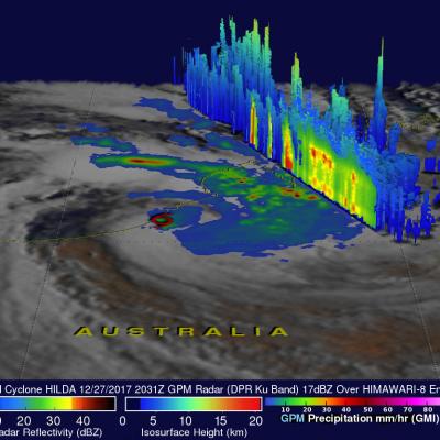
Tropical cyclone HILDA formed very close to Australia's northwestern coast on December 27, 2017 at 1800 UTC and dissipated quickly as it crossed over land. The GPM core observatory satellite had a good view of the short lived tropical cyclone on December 27, 2017 at 2031 UTC. A red tropical storm symbol shows HILDA's approximate location when GPM passed above. The center of GPM's coverage was mainly east of HILDA's center of circulation. The intensity of rainfall in a large intense band of storms wrapping around the northeastern side of the tropical cyclone was measured by the satellite's

Tropical Cyclone Ockhi's Rainfall Examined By GPM

On December 2, 1027 OCKHI became the first tropical cyclone of the year to form in the Arabian Sea. Fortunately for India the tropical cyclone remained off India's southwestern coast. OCKHI intensified to the equivalent of a category 3 hurricane on the Saffir-Simpson hurricane wind scale before it started to weaken. Vertical wind shear caused OCKHI to weaken as the tropical cyclone started moving north-northeastward toward India's Gulf of Khambhat. NASA's GPM Core Observatory satellite passed over tropical cyclone OCKHI on December 4, 2017 at 0616 UTC. The rainfall coverage shown here was

GPM Observes Tropical Cyclone Dahlia In Southwest Indian Ocean

Yesterday tropical Cyclone Dahlia became the first tropical cyclone of the 2017-2018 Southwest Indian Ocean season. Today, Dahlia was moving toward the southeast and was passing to the south of the Indonesian islands of Java and Sumatra with wind speeds of about 35 kts (40.3 mph). Tropical cyclone Dahlia was passing over the warm ocean waters (28-29 degrees Celsius) of the Indian Ocean. On November 29, 2017 at 1731 UTC NASA's GPM Core Observatory satellite passed above forming tropical cyclone Dahlia. Data collected by GPM's Microwave Imager (GMI) and Dual-Frequency Precipitation Radar (DPR)

Rainfall In Southeast Asia Analyzed By GPM

Tropical storm Khanun formed northeast of the Philippines on October 12, 2017. The GPM core observatory satellite passed above Khanun on October 13, 2017 (0656 UTC) when maximum sustained wind speeds had reached about 45 kts (~52 mph). Khanun had passed over the northern Philippines and was moving into the South China Sea. The approximate location of Khanun's center of circulation is shown with a red tropical storm symbol. The intensifying tropical storm's rainfall is shown in this image courtesy of data collected by GPM's Microwave Imager (GMI) and Dual-Frequency Precipitation Radar (DPR)
A New Multi-dimensional View of a Hurricane
Download in high resolution from the NASA Goddard Scientific Visualization Studio NASA researchers now can use a combination of satellite observations to re-create multi-dimensional pictures of hurricanes and other major storms in order to study complex atmospheric interactions. In this video, they applied those techniques to Hurricane Matthew. When it occurred in the fall of 2016, Matthew was the first Category 5 Atlantic hurricane in almost ten years. Its torrential rains and winds caused significant damage and loss of life as it coursed through the Caribbean and up along the southern U.S...

Rainfall In Potential Tropical Cyclone Analyzed

A tropical cyclone may be forming in the northwestern Pacific Ocean near Chichi-Jima, Japan. The GPM core observatory satellite flew directly above very strong convective storms in this potential tropical cyclone on July 13, 2017 at 0834 UTC. Rainfall in the area was analyzed using data collected by GPM's Microwave Imager (GMI) and Dual-Frequency Precipitation Radar (DPR) instruments. One area of extremely intense storms was measured by GPM's radar (DPR Ku Band) dropping rain at a rate of over 198mm (7.8 inches) per hour. Data from the GPM satellite's radar (DPR Ku band) was also used to

GPM Sees Possible Tropical Cyclone Forming

A low pressure system in the Atlantic Ocean west-southwest of the Cabo Verde Islands is being closely monitored for possible development into a tropical depression. The GPM core observatory satellite flew over this area on July 5, 2017 at 5:47 AM EDT (0947 UTC). GPM's Microwave Imager (GMI) and Dual-frequency Precipitation Radar (DPR) showed that heavy showers were located in this area. GPM's GMI data indicated that rain was coming down at a rate of greater than 44.2 mm (1.74 inches) per hour in one cluster of storms. GPM's radar (DPR Ku band) measured precipitation falling at rate of over

GPM Views Intensifying Tropical Storm Nanmadol

The GPM core observatory satellite flew above tropical storm NANMADOL on July 2, 2017 at 2306 UTC. The intensifying tropical storm was located just northeast of Taiwan and had maximum winds estimated at 45 kts (51.8 mph). The GPM Core Observatory carries the first space-borne Ku/Ka-band Dual-frequency Precipitation Radar (DPR) and a multi-channel GPM Microwave Imager (GMI). Rainfall within NANMADOL was derived from data collected by GPM's GMI and DPR instruments. Those data indicated that rain was falling at a rate of greater that 184 mm (7.2 inches) per in powerful storms northeast of the

GPM Satellite Sees Cindy Drenching Gulf Coast

The GPM core observatory satellite passed above as tropical storm Cindy was approaching the western Louisiana coast on June 22, 2017 at 1:21 AM CDT (0621 UTC). Cindy had maximum sustained winds of about 40 kts (46 mph) at that time. A red tropical storm symbol shows Cindy's approximate location. Rainfall derived from Microwave Imager (GMI) and Dual-Frequency Precipitation Radar (DPR) measurements showed that there was very little rainfall near Cindy's center of circulation but bands of moderate to heavy showers are shown moving into the states along the Gulf Coast. GPM's Radar (DPR Ku Band)

Potential Tropical Cyclone (02L) Examined By GPM

A couple weeks after the official start of the Atlantic hurricane season the tropical Atlantic Ocean is starting to show potential tropical cyclone development. The National Hurricane Center (NHC) has indicated that potential tropical cyclone 02L, located east-southeast of Trinidad, will likely become a tropical storm within the next five days. The GPM core observatory satellite flew above 02L on June 19, 2017 at 00:16 AM EDT (0416 UTC). Data collected by Microwave Imager (GMI) and Dual-Frequency Precipitation Radar (DPR) instruments showed that the potential tropical cyclone contained some