tropical cyclones

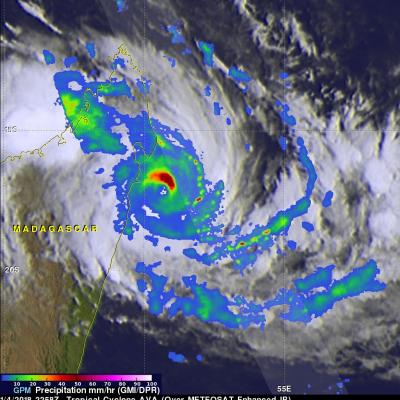
GPM Examines Tropical Cyclone Gita Over Samoa

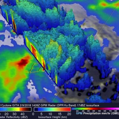
Recently formed tropical cyclone GITA was drenching Samo when the GPM core observatory satellite passed above on February 9, 2018 at 1426 UTC. Data collected by GPM's Microwave Imager (GMI) and Dual-Frequency Precipitation Radar (DPR) instruments showed the area and intensity of precipitation associated with the tropical cyclone. The area covered by GPM's radar swath is shown in lighter shades. GITA was producing heavy rainfall over a large area that included the islands. The center of the intensifying tropical cyclone was located just to the south of the islands. Rainfall in that area was

Weakening Tropical Cyclone Cebile Examined By GPM

The GPM core observatory satellite passed above weakening tropical cyclone CEBILE on February 6, 2018 at 1151 UTC. CEBILE's maximum sustained winds had decreased to about 40 kts (46 mph). The satellite showed that most of the convective rainfall in the sheared tropical cyclone was southeast of CEBILE's center of circulation. Dual Frequency Precipitation Radar (DPR) data received by GPM with this pass showed that the northeastern side of the eye wall was eroding while continuous heavy precipitation was found by GPM in the southeastern quadrant of the storm. The area scanned by GPM's DPR is

GPM Probes Powerful Tropical Cyclone Cebile

Tropical Cyclone CEBILE formed four days ago in the southwest Indian Ocean southeast of Diego Garcia. Today CEBILE became the most powerful tropical cyclone to form in the southern hemisphere this year. Maximum sustained wind speeds within CEBILE were estimated at 120kts (138 mph) early today making CEBILE the equivalent of a category 4 hurricane on the Saffir-Simpson hurricane wind scale. The GPM core observatory satellite passed directly above the well defined circular eye of tropical cyclone CEBILE on January 31, 2018 at 0034 UTC. Rainfall intensity and coverage within CEBILE were revealed

GPM Views Sheared Tropical Cyclone Fehi

The GPM core observatory satellite flew tropical cyclone FEHI on January 30, 2018 at 0831 UTC. GPM revealed that precipitation was only located around the southern side of FEHI's circulation. Strong vertical wind shear had caused the surface center of circulation (shown with a red symbol) to be displaced well to the north of the heaviest rainfall. The satellite found that some convective storms on the southern side of the tropical cyclone were still producing very heavy precipitation. GPM's Microwave Imager (GMI) and Dual Frequency Precipitation Radar (DPR) instruments revealed rainfall in a

GPM Sees Tropical Cyclone Berguitta Battering Mauritius

Tropical cyclone BERGUITTA was moving very close to the eastern side of the island of Mauritius when the GPM core observatory satellite passed above on January 18, 2018 at 0528Z (9:28 AM local time). This meant that the most destructive section of tropical cyclone BERGUITTA was passing very close to the eastern side of Mauritius. For this reason the eastern side of Mauritius would be expected to have had the highest winds, seas, and storm surge from BERGUITTA. The tropical cyclone was passing a little farther to the east of the island of Reunion. Data collected by GPM's Microwave Imager (GMI)

GPM Sees Tropical Cyclone Berguitta Bearing Down On Mauritius

The GPM core observatory satellite passed over the southwest Indian Ocean on January 16, 2018 at 1856 UTC. GPM showed that heavy rainfall within tropical cyclone BERGUITTA was moving closer to the islands of Reunion and Mauritius. GPM's Microwave Imager (GMI) and Dual Frequency Precipitation Radar (DPR) instruments found that powerful storms northeast of Mauritius were dropping rain at a rate greater than 54 mm (2.1 inches) per hour. A 3-D view of Storm top heights within tropical cyclone BERGUITTA was made possible with GPM's radar (DPR ku Band). Those 3-D scans through the eastern side of

IMERG Reveals Rainfall Rates With Tropical Cyclone Berguitta

Tropical cyclone BERGUITTA formed in the southwestern Indian Ocean northeast of the islands of La Reunion and Mauritius on January 12, 2018. BERGUITTA is now moving toward the southwest and threatening the islands. Early on January 16,2018 BERGUITTA had maximum sustained winds estimated at 100 kts (115 mph). This means that BERGUITTA was the equivalent of a category three hurricane on the Saffir-Simpson hurricane wind scale. Later in the day BERGUITTA's maximum sustained wind speeds were estimated at 85 kts (98 mph) with gust to 105 kts (121 mph). On January 16, 2018 at 1200Z tropical cyclone

Tropical Cyclone Ava's Disastrous Rainfall Measured With IMERG

Tropical cyclone Ava dropped extremely heavy rainfall over Madagascar as it passed over the eastern side of the island country from January 5-6, 2018. Ava's drenching rainfall caused flooding and landslides which resulted in the deaths of at least 29 people. An estimated 80,000 people on Madagascar were affected by the tropical cyclone. This rainfall analysis was produced by accumulating rainfall that fell near Madagascar during the period from January 2-8, 2018. These IMERG estimates showed the locations of extreme rainfall totals during the period when tropical cyclone Ava was in Madagascar

Powerful Tropical Cyclone Irving Examined With GPM

Tropical cyclone Irving formed in the South Indian Ocean on January 6, 2018. Irving posed no threat to land because it orgininated over the open ocean far to the west of Australia. GPM's core observatory satellite had an excellent view of Irving's eye on January 2018 at 0706Z. The well defined rainfall patterns within Irving were clearly shown by GPM's Microwave Imager (GMI) and Dual Frequency Precipitation Radar (DPR) data. Very heavy rainfall was shown in the western side of Irving's large eye wall. GPM's Radar (DPR Ku Band) found rain in that side of the tropical cyclone falling at a rate

Tropical Cyclone Ava Viewed By GPM

Tropical cyclone AVA formed in the southeast Indian Ocean northeast of Madagascar on January 2, 2018. AVA became increasingly powerful and approached the eastern coast of Madagascar with maximum sustained winds estimated to be greater than 90 kts (103.5 mph). AVA has been interacting with land and wind speeds near Tamatave, Madagascar have been reported to be 70 kts (80.5 mph). The Joint Typhoon Warning Center (JTWC) predicts that tropical cyclone AVA will move to the south along Madagascar's eastern coast for a day or so and then return to the Indian Ocean. Very heavy rainfall is expected to