tropical storms

Deadly Flooding Rainfall Over Texas And Tropical Storm Bonnie Measured From Space

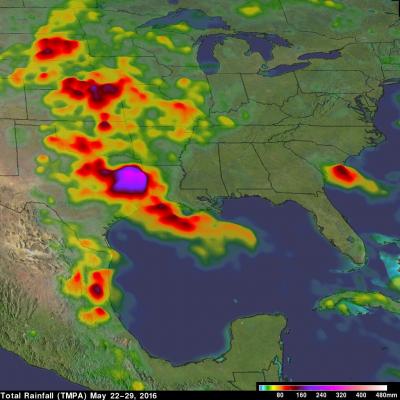
Heavy rainfall caused deadly flooding in southeastern Texas. At least 4 people have been killed and continuing rainfall is expected to cause historic flooding in that area. Meanwhile, dissipating Tropical storm Bonnie is soaking the South Carolina coast, southeastern North Carolina and eastern Georgia on this Memorial Day weekend. Some flooding is expected as dissipating tropical storm Bonnie's rainfall moves northeastward along the coast. This analysis of liquid precipitation from space was accomplished by using merged satellite rainfall data from the TRMM Multi-satellite Precipitation

Developing Tropical Storm Triggers Deadly Landslides in Sri Lanka

A storm does not have to be especially powerful in terms of its winds to be deadly. Such is the case with Tropical Cyclone 01B (TC 01B) in the Bay of Bengal. Despite only reaching minimal tropical storm intensity just this morning at 06 UTC 18 May 2016, the system has been responsible for dumping heavy rains in and around Sri Lanka and southern Indian over the past few days as it tried to organize itself in the southwestern Bay of Bengal. This set the stage for two massive landslides, which buried 3 villages in south central Sri Lanka. So far, although several hundred people have been rescued

Intensifying Atlantic Storm Examined By GPM

On February 8, 2016 at 0800 UTC (3 AM EST) the GPM core observatory satellite flew above an intensifying storm in the Atlantic Ocean off the United State's East Coast. This storm is forecast by the National Weather Service (NWS) to bring strong winds, heavy rainfall, and coastal flooding to the Carolina's. Although the center of the storm is well off the coast, bands of precipitation from the storm are also expected to bring heavy snow to eastern New England. A rainfall analysis derived from data collected by GPM's Microwave Imager (GMI) and Dual-frequency Precipitation Radar (DPR) instruments

Tropical Storm Sandra

Early this morning tropical Storm Sandra became the 18th named storm of the 2015 Eastern Pacific hurricane season. Intensifying tropical storm Sandra had winds of about 35 kts (40 mph) when the GPM core observatory satellite passed over on November 24, 2015 at 0719 UTC. A rainfall analysis derived using data collected at that time by from GPM's Microwave Imager (GMI) and Dual-Frequency Precipitation Radar (DPR) instruments is shown. DPR discovered that the intense convective storms south of the tropical storm's center of circulation were dropping rain at a rate of over 80 mm (3.1 inches) per

Tropical Storm Rick Examined By GPM

Tropical storm Rick is the latest tropical cyclone to form in the 2015 Eastern Pacific Ocean hurricane season which has spawned a record number of dangerous hurricanes. Tropical storm Rick was moving over the eastern Pacific Ocean well off the Mexican coast when the GPM core Observatory satellite flew over on November 19, 2015 at 1956 UTC. Data captured by GPM's Microwave Imager (GMI) and Dual-Frequency Precipitation Radar (DPR) show that tropical storm Rick had a couple areas near the center of circulation that were dropping rain at a rate of over 41.6 mm (1.6 inches) per hour. GPM's radar

Tropical Storm Kate Examined By GPM

Kate became the twelfth named tropical cyclone of the of the 2015 Atlantic hurricane season when it formed near the southeastern Bahamas on Sunday November 8, 2015. Kate re-curved toward the northeast and moved harmlessly over the open waters of the Atlantic. Kate's intensity peaked on November 11, 2015 with winds of about 65 kts making it a category one hurricane on the Saffir-Simpson Hurricane. The GPM core observatory satellite flew above Kate on November 11, 2015 at 0926 UTC (4:26 AM EST) capturing data used in these images. Kate's maximum sustained winds were estimated at about 60 kts (69

GPM Sees Chapala Traveling Toward Yemen

Powerful tropical cyclone Chapala continues moving inexorably toward Yemen. Chapala has weakened from category four intensity a couple days ago while maintaining a course that steers it toward Yemen. The GPM core observatory satellite had a good look at tropical cyclone Chapala on October 31, 2015 at 0331 UTC. GPM's rainfall data are shown overlaid on a 0330Z METEOSAT-7 Visible/Infrared image. At that time Chapala was a very powerful tropical cyclone with maximum sustained winds of about 117 kts (135 mph). GPM's Microwave Imager (GMI) instrument measured rain dropping at a rate of over 88 mm

GPM Examines Tropical Cyclone Chapala

Tropical Cyclone Chapala developed in the very warm waters of the Arabian Sea west of India on October 28, 2015. These images show rainfall derived from data collected by GPM's Microwave Imager (GMI) and Dual-Frequency Precipitation Radar (DPR) instruments. The GPM core observatory satellite had good views of the tropical cyclone on October 29, 2015 at 0332 and 1456 UTC. GPM's rainfall from the first pass show that Chapala was close to hurricane intensity with the location of a developing eye clearly shown by GMI. By the second pass Chapala's maximum sustained winds were estimated at 65 kts

Weakening Tropical Storm Olaf Examined By GPM

After maintaining hurricane intensity for over a week former category four hurricane Olaf is now a weakening tropical storm. The GPM core observatory satellite flew above Olaf on October 26, 2015 at 0510Z. Rainfall derived from data collected by GPM's Microwave Imager (GMI) and Dual-Frequency Precipitation Radar (DPR) instruments is shown here. Olaf had moved over cooler waters that were sapping the tropical cyclone's energy. GPM's GMI found that storms located in a small area within Olaf were still dropping rain at a rate of over 65 mm (2.6 inches) per hour. GPM's radar (DPR Ku band) sliced

Tropical Storm Patricia Forms Off Mexican Coast

Tropical Depression Twenty-E (TD20E) formed on October 20, 2015 off the Mexican coast southeast of Puerto Escondido, Mexico. Later that evening TD20E was upgraded to tropical storm Patricia. On October 21, 2015 at 1634 UTC (11:34 AM CDT) the GPM core observatory satellite flew over tropical storm Patricia. GPM's Microwave Imager (GMI) instrument had good coverage of the rainfall associated with the tropical storm. Rainfall data derived from GMI are shown overlaid on a GOES-EAST Visible/Infrared image captured at 1645 UTC (11:45 AM CDT). GPM's Dual-Frequency Precipitation Radar (DPR) instrument