tropical storms

GPM Observes Tropical Storm Gaston's Development

Tropical storm Gaston became the 7th named tropical storm in the Atlantic Ocean after forming southwest of the Cape Verde Islands on Monday evening August 22, 2016. Gaston's development followed closely behind tropical storm Fiona that formed in the same area southwest of the Cape Verde Islands on August 17, 2016. Fiona is now fading quickly in the Atlantic Ocean southwest of Bermuda. Tropical storm Gaston is predicted by the National Hurricane Center (NHC) to intensify and become a hurricane on August 24, 2016. Gaston is expected to move into the center of the Atlantic Ocean well east of

Tropical Storm Javier Forms In The Eastern Pacific

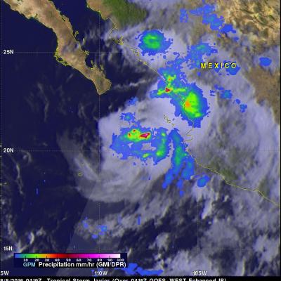
Tropical storm Javier formed on August 7, 2016 in the Eastern Pacific Ocean off Mexico's western coast. Javier formed partially from the remnants of Hurricane Earl. Landslides caused by heavy rainfall from Hurricane Earl caused the reported deaths of at least 39 people in eastern Mexico. The GPM core observatory satellite flew above tropical storm Javier on August 8, 2016 at 0419 UTC. Rainfall was analyzed using GPM's Microwave Imager (GMI) and Dual-Frequency Precipitation Radar (DPR) instruments. Those data showed that Javier was producing heavy rainfall both near the center of the tropical

GPM Sees Towering Thunderstorms In Intensifying Tropical Storm Earl

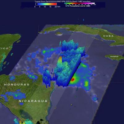
Tropical storm Earl has been intensifying as it moves through the Caribbean Sea. The National Hurricane Center (NHC) now predicts that Earl will be a hurricane before it hits Mexico's Yucatan Peninsula tomorrow afternoon. Earl is predicted by NHC to remain in a light to moderate vertical wind shear environment over very warm sea surface temperatures until landfall. The GPM core observatory satellite passed over intensifying tropical storm Earl in the Caribbean Sea northeast of Honduras on August 3, 2016 at 0356 UTC ( August 2, 2016 11:56 PM EDT). GPM's Microwave Imager (GMI) and Dual-Frequency

GPM Sees Tropical Storm Earl Forming

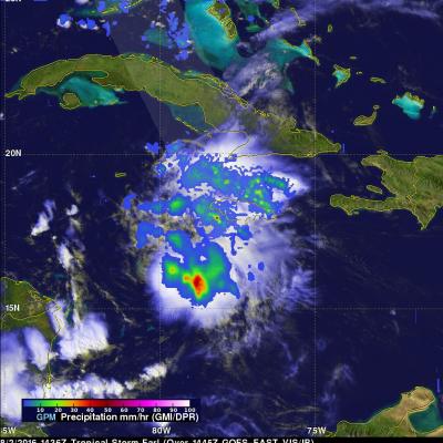
Today a tropical wave in the Caribbean Sea south of Cuba developed a closed circulation center and was then designated tropical storm Earl by the National Hurricane Center (NHC). Earl is the fifth tropical cyclone to form in the Atlantic Ocean this year. The GPM core observatory satellite flew over the forming tropical storm on August 2, 2016 at 1436 UTC (10:36 AM EDT). GPM's Microwave Imager (GPM) and Dual-Frequency Precipitation Radar (DPR) data were used in this analysis to show precipitation accompanying Earl. GPM's GMI provided excellent coverage of heavy convective rainfall in the

Tropical Storm Darby Brings Occasionally Heavy Rain To The Hawaiian Islands

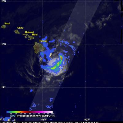
Tropical storm Darby has caused some heavy rainfall in the Hawaiian Islands since hitting the big island (Hawaii) on Saturday July 23, 2016. After hitting the big island Darby passed to the south of Molokai and Maui. Rain falling at a rate of 25.4 mm (1 inch) to 50.8 mm (2 inches) per hour was reported on the island of Oahu as Darby passed to the southwest of the island. The National Weather Service office in Honolulu reported that parts of Interstate H-1 that serves the southern side of Oahu was closed due to flooding on Sunday night. Darby is affecting northern Kaui today. The GPM core

GPM Used To Evaluate Tropical Storm Estelle

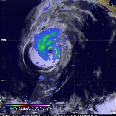
The GPM core observatory satellite traveled above tropical storm Estelle on July 19, 2016 at 1036 UTC. This pass showed that Estelle contained well organized convective bands that were producing precipitation within the storm. Precipitation within Estelle was analyzed using data collected by GPM's Microwave Imager (GMI) and Dual-Frequency Precipitation Radar (DPR) instruments. GPM's radar (DPR Ku band) data were used to perform a 3-D examination of the precipitation on the eastern side of tropical storm Estelle. Some rainfall was measured by DPR falling at a rate of over 65 mm (2.6 inches) per

Rainfall Measured By GPM In Weakening Tropical Storm Celia

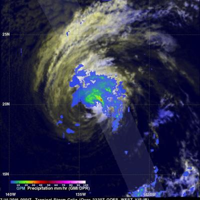
Celia was a powerful hurricane with winds of 85 kts (98 mph) a couple days ago but has recently been moving over cooler ocean waters that are contributing to a weakening trend. Hurricane Celia had weakened to a tropical storm with winds of about 45 kts (52 mph) when the GPM core observatory satellite flew over on July 14, 2016 at 0001 UTC. GPM found that convective storms were mainly located to the north and northeast of Celia's center of circulation. GPM's Microwave Imager (GMI) and Dual-Frequency Precipitation Radar (DPR) found that rain was falling at over 164 mm (6.4 inches) per hour

Forming Tropical Storm Darby Analyzed By GPM

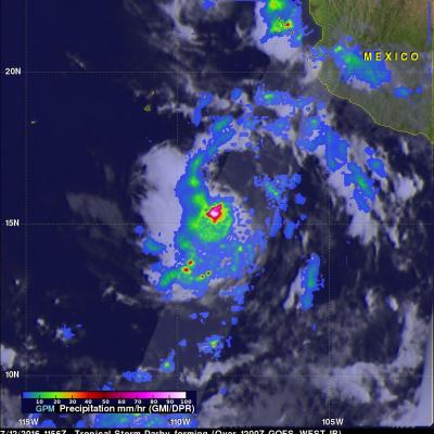
Tropical storm Darby became the fourth eastern Pacific Ocean tropical storm to form on July 12, 2016. Last year was an El Nino year and this year is transitioning to a La Nina year with cooler sea surface temperatures (SST) expanding across the eastern equatorial Pacific Ocean. Fewer tropical storms are normally expected to develop in the eastern Pacific Ocean during La Nina years but so far this year tropical cyclones are forming in the eastern Pacific Ocean at about the same pace as last year. The GPM core observatory satellite flew above tropical depression five (TD05E) on July 12, 2016 at

Danielle Hits Mexico And Weakens

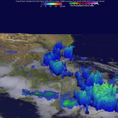
Tropical Storm Danielle started weakening after making landfall north of Tuxpan, Mexico on Monday evening just before June 21, 2016 at 0000 UTC (June 20, 2016 7:00 PM CDT). As Danielle weakened the low level circulation quickly became disorganized. The GPM core observatory satellite passed above rapidly weakening Danielle on June 21, 2016 at 0421Z (June 20, 2016 11:21 PM CDT). The approximate center of Danielle's circulation at the time of this GPM pass is shown with a red tropical storm symbol. A rainfall analysis from GPM's Microwave Imager (GMI) and Dual-Frequency Precipitation Radar (DPR)

Tropical Storm Colin Takes Aim at Florida

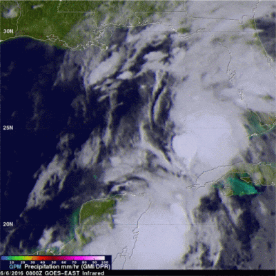
Although hurricane season officially begins on June 1st, we already have the 3rd named storm of the season with the arrival of Tropical Storm Colin, which formed yesterday at 21:30 UTC (4:30 pm CDT) in the southern Gulf of Mexico about 120 miles north of the Yucatan Peninsula. Colin originated from a wave of low pressure that propagated across the tropical Atlantic and northern coast of South America and into the southern Caribbean. As thunderstorm activity picked up, the wave slowly organized into an area of low pressure as it turned northward and passed over the Yucatan. After entering the