Extreme Weather News

Jump to a Year

2022 | 2021 | 2020 | 2019 | 2018

2017 | 2016 | 2015 | 2014 | 2013

2012 | 2011 | 2010 | 2009 | 2008

2007 | 2006 | 2005 | 2004 | 2003

2002

NASA's IMERG Used To Analyze Tropical Storm Usagi's Rainfall

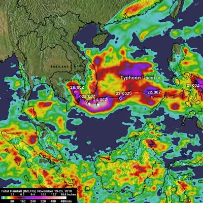
Usagi strengthened to hurricane intensity as it approached Vietnam from the South China Sea but weakened to tropical storm intensity when coming ashore. Very heavy rainfall and damaging winds accompanied tropical storm Usagi when it hit Vietnam's southern coast. More than 350 mm (14 inches) of rainfall was reported causing widespread flooding around Ho Chi Minh City. NASA's Integrated Multi-satellitE Retrievals for GPM (IMERG) data were used to show estimates of rainfall accumulation produced by Usagi as the tropical cyclone moved across the South China Sea into Southeast Asia. This IMERG

Tropical Cyclone Gaja's Rainfall Measured With IMERG

Tropical cyclone Gaja recently caused the deaths of at least 33 people in the southern India state of Tamil Nadu. Gaja's high wind and heavy rains caused landslides and building collapses. Gaja's maximum sustained winds had reached about 75kts (86 mph) when it hit southern India on Friday November 16, 2018. This meant that Gaja was the equivalent of a category one on the Saffir-Simpson hurricane wind scale. Today another tropical low is also moving over southern India and is expected to produce more heavy rainfall in the same area. NASA's Integrated Multi-satellitE Retrievals for GPM (IMERG)

Italy's Extreme Rainfall Examined With IMERG

During the past week a strong low-pressure system moving through southern Europe battered, drenched and flooded Italy. It caused flooding, landslides and other damage to large areas of the country. The deaths of at least 11 people have been attributed to this stormy weather. High winds knocked down many trees and heavy rainfall from these storms contributed to flooding in large areas of Italy. Venice was inundated when heavy rain fell and a surge of water from the Adriatic Sea was pushed into the city by the storm's very high winds. Data from various satellites, that cover most of the globe

GPM Examines Weaker Tropical Storm Yutu in the South China Sea

Typhoon YUTU (known as Rosita in the Philippines) is now threatening the Philippine Island of Luzon. On October 24, 2018 YUTU devastated the northern Mariana Islands of Tinian and Saipan as a super typhoon. One death has been attributed to the typhoon in the Marianas with many structures including schools and hospitals being destroyed. Typhoon YUTU weakened as it moved toward the Philippines and had maximum sustained winds of about 90 kts (103.5 mph) when the GPM core observatory satellite passed above the Philippine Sea on October 29, 2018 at 0212 UTC. This rainfall analysis was developed
GPM Catches Typhoon Yutu Making Landfall
NASA's GPM Core observatory satellite captured an image of Super Typhoon Yutu when it flew over the powerful storm just as the center was striking the central Northern Mariana Islands north of Guam. Early Thursday, Oct. 25 local time, Super Typhoon Yutu crossed over the U.S. commonwealth of the Northern Mariana Islands. It was the equivalent of a Category 5 hurricane. The National Weather Service in Guam said it was the strongest storm to hit any part of the U.S. this year. Download this video in high resolution from the NASA Goddard Scientific Visualization Studio Download video without...