Extreme Weather News

Jump to a Year

2022 | 2021 | 2020 | 2019 | 2018

2017 | 2016 | 2015 | 2014 | 2013

2012 | 2011 | 2010 | 2009 | 2008

2007 | 2006 | 2005 | 2004 | 2003

2002

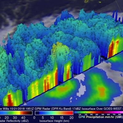
Dangerous Hurricane Willa Probed By GPM Satellite

Hurricane Willa was moving northward toward the western coast of Mexico when the GPM core observatory passed above on October 21, 2018 at 1:51 PM MDT (1951 UTC). The hurricane had maximum sustained winds of about 95 mph (109 kts). Since then Willa has rapidly intensified and today has winds of 155 mph (135 kts) making it a dangerous category four on the Saffir-Simpson hurricane wind scale. GPM's Microwave Imager (GMI) and Dual-Frequency Precipitation Radar (DPR) instruments collected data showing that hurricane Willa and feeder bands were producing heavy rainfall over a large area. The

GPM IMERG Measures Hurricane Michaels Rainfall Accumulation

At least eleven deaths have now been attributed to deadly hurricane Micheal. Some casualties resulted not only from Micheal's destructive winds and storm surges but also from the blinding rain that Micheal produced as it battered states from Florida northeastward through Virginia. Today tropical storm Micheal is moving out over the Atlantic Ocean and has transitioned into a powerful extratropical storm. This animation using the GPM IMERG multi-satellite dataset shows the estimated total rainfall accumulation for #HurricaneMichael from 10/8/18 - 10/12/18. Learn more: https://t.co/aJuEp6o855 pic

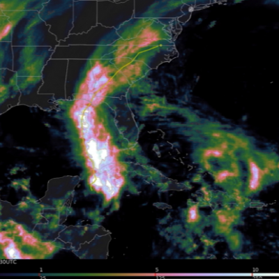
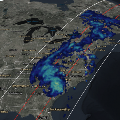
GPM Views Downgraded Hurricane Michael Soaking the Eastern U.S.

View fullscreen in STORM Event Viewer Hundreds of miles way from its landfall in Mexico Beach, Florida, Michael has been downgraded to a tropical storm, but it continues to pack a punch. Waterlogged regions of the Carolinas from Hurricane Florence are seeing trees toppled in the gusty winds, while rain falling in the Appalachian Mountains is leading to flash flooding and water rescues. Widespread power outages and flooding remain likely as the storm moves to the northeast through the rest of the day.

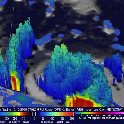
GPM Scans Tropical Storm Nadine

Tropical Depression fifteen was located southwest of the Cabo Verde Islands when it became tropical storm Nadine early on October 9, 2018. The GPM core observatory collected significant information about Nadine when it scanned the tropical storm's center of circulation on October 10, 2018 at 3:01 AM EDT (0701 UTC). Nadine was a small tropical storm but GPM's Microwave Imager (GMI) and Dual-Frequency Precipitation Radar (DPR) data revealed that extreme rainfall was occurring in areas around the center of the tropical cyclone. GPM's radar (DPR Ku Band) measurements indicated that rain was
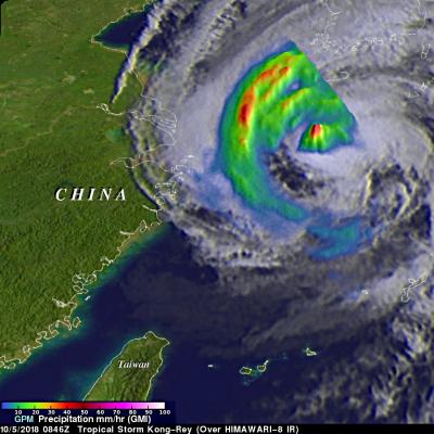
GPM's GMI Measures Weakening Kong-Rey's Rainfall JacobAdmin Thu, 10/04/2018
The GPM core observatory passed above tropical storm Kong-Rey on October 5, 2018 at 0846 UTC. Kong-Rey was a powerful category five typhoon just a few days ago but increased vertical wind shear and cooler sea surface temperatures have caused the tropical cyclone to weaken dramatically. Tropical storm Kong-Rey had maximum sustained winds of about 55 kts (63 mph) when it was scanned by the satellite. GPM's Microwave Imager (GMI) data were used to gauge the intensity of precipitation around Kong-Rey's center of circulation. Energy observed through clouds by GMI's microwave channels was used to