Dominican Republic And Haiti Hit By Deadly Floods

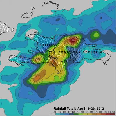
It has been reported that spring floods with mudslides have resulted in the death of at least 9 people and forced 11,000 people to flee their homes in the Dominican Republic. Data from the TRMM satellite are used to calibrate rainfall data merged from various satellite sources. TRMM-based, near-real time Multi-satellite Precipitation Analyses (TMPA) at the NASA Goddard Space Flight Center are used to monitor rainfall over the global Tropics. TMPA rainfall estimates are shown above for the week from April 19 to April 26, 2012. This analysis shows that extreme rainfall (shown in dark red)

Tornadoes Devastate Parts of the Great Plains

It's springtime in the Plains, which means the increased likelihood that severe weather, including tornadoes, will occur somewhere across the region. After a week of relative quiet, a strong storm system moved out of the southern Rockies and out into the Central Plains. In association with this system, strong southerly winds at low levels drew Gulf moisture up across Texas and into Oklahoma and Kansas while strong jet-stream winds aloft raced northeastward around the base of an upper-level trough over the four-corners region and out over the Plains, setting the stage for a potential severe

Handover of Japan-built Radar to NASA

By Ellen Gray, NASA Goddard Space Flight Center Original www.nasa.gov Press Release (published 4/3/12) On March 30, the Japan Aerospace Exploration Agency (JAXA) officially handed off a new satellite instrument to NASA at Goddard Space Flight Center, Greenbelt, Md. The Dual-frequency Precipitation Radar (DPR) was designed and built by JAXA and Japan's National Institute of Information and Communications Technology (NTSpace). JAXA DPR Project Manager Masahiro Kojima (seated left) formally signed over the DPR to GPM Project Manager Art Azarbarzin (seated right). Behind from left to right: Minoru

MicroRain Radar in the Smokies

MicroRain Radar in the Smokies
Image Caption
MicroRain Radar at Purchase Knob in the Great Smoky Mountains National Park.

This instrument is a vertical profiler radar that delivers information about structure in the atmospheric column and enables scientists to estimate the vertical distribution of rainfall. At all times of the day, light rainfall is the dominant type of precipitation. 

Light Rain in the Smokies

A misty mountaintop in the Smokies
Image Caption
Mid-morning peak in light rainfall appears as clouds and fog at Purchase Knob in the Great Smoky Mountains National Park.

Light rainfall is the most reliable and most frequent form of rainfall in the region, contributing 50 to 60 percent of the total precipitation over a year. Light rain is no less than the lifeline of freshwater resources for the landscape’s ecosystems.