Late Season Tropical Storm Kuena Forms

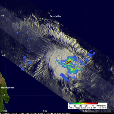
A tropical storm called Kuena formed in the southwest Indian Ocean east of Madagascar on June 6, 2012. This is a little unusual because the tropical cyclone season in that area normally ends on May 15. The TRMM satellite had an excellent view of Kuena when it flew directly above the newly formed storm on June 6, 2012 at 1607 UTC. A rainfall analysis that used data from TRMM's Microwave Imager (TMI) and Precipitation Radar (PR) instruments is shown overlaid on an enhanced infrared image from TRMM's Visible and InfraRed Scanner (VIRS) instrument. This analysis shows that heavy convective storms

Successful Electrical Integration of GPM’s Two Instruments

The electrical integration of the Global Precipitation Measurement Microwave Imager (GMI) instrument onto the GPM Core Observatory was successfully completed in April 2012. Ball Aerospace and Technologies Corp. Boulder, Colo. built the GMI, which arrived at NASA's Goddard Space Flight Center in Greenbelt, Md. in early March and after post shipment processing it was handed over to NASA. The GMI is one of the key instruments for the GPM Core Observatory. This instrument is a passive radiometer with 13 channels covering frequencies from 10 to 183 GHz. In May, 2012, the Dual-frequency

Tropical Storm Beryl Brings Some Much Needed Drought Relief to Southeast US

Tropical Storm Beryl was actually a welcome sight in parts of the Southeast. Tropical cyclones are not always bad news. Sometimes they can be quite beneficial, especially when it comes to relieving drought conditions. Tropical Storm Beryl made landfall just after midnight (local time) on the night of 27 May 2012 near Jacksonville Beach, Florida as a strong tropical storm with sustained winds of 70 mph, making it the strongest tropical cyclone to make landfall in the US before the official June 1st start of the Atlantic hurricane season. Prior to the arrival of Beryl, many parts of the