Hurricane Carlotta Moves Toward Mexican Coast

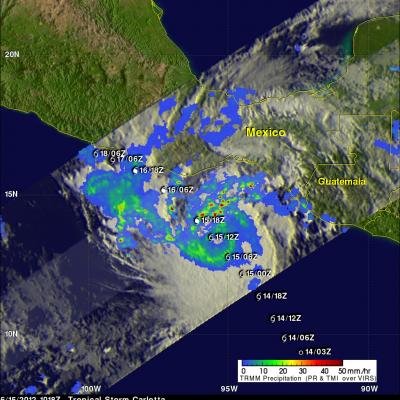
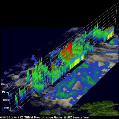
The TRMM satellite flew over hurricane Carlotta again on Friday June 15, 2012 at 1018 UTC. TRMM's Microwave Imager (TMI) showed that Carlotta was much better organized and revealed a developing eye. Heavy rainfall in bands spiraling into the center of Carlotta are shown by TRMM's Precipitation Radar (PR). Past positions and the National Hurricane Center's forecast positions are shown overlaid in white. Carlotta is forecast to become a category two hurricane tomorrow with sustained wind speeds increasing to 85kts (~98 mph) as it nears the Mexican coast.

Intensifying Typhoon Guchol Viewed By TRMM

Typhoon Guchol in the western Pacific Ocean is becoming increasingly more powerful and was seen by the TRMM satellite on Friday June 15, 2012 at 0443 UTC. The center of the intensifying typhoon was covered very well by TRMM's Precipitation Radar (PR) data. TRMM PR showed that very heavy rainfall was occurring in the eastern side of Guchol's eye wall. This 3-D image (looking toward the east) from TRMM PR data reveals that towering storms in the eastern side of Guchol's eye were reaching the amazing height of almost 17km (~10.56 miles). Intense rainfall in Guchol's eye wall was returning values

Tropical Storm Guchol Slowly Strengthens

The tropical depression (05W) that became tropical storm Guchol yesterday formed southeast of Guam on June 11, 2012. TRMM had a fairly good daytime look at Guchol on June 13, 2012 at 0500 UTC. TRMM's Microwave Imager (TMI) data revealed that Guchol contained a large area of moderate to heavy rainfall. Guchol is expected to continue moving toward the northwest, slowly intensify and reach minimal typhoon strength on June 14, 2012.

TRMM Sees Flooding Rainfall Along Gulf

The states along the coast of the Gulf of Mexico experienced very heavy rainfall on Saturday June 9,2012 and Sunday June 10, 2012. The images above use TRMM satellite data collected when it flew over on Sunday June 10, 2012. Unusually heavy rainfall was occurring in states near the Gulf coast. Due to the path of TRMM's orbits it had good coverage with more than one orbit. The first orbit occurred at 1501 UTC (11:01 AM EDT). The second image shows a combination of more than one orbit with the later data being collected at about 1817 UTC (2:17 PM EDT). TRMM rainfall analyses from these orbits

Global Precipitation Measurement Constellation

Submitted by JacobAdmin on

Nine U.S. and international satellites will soon be united by the Global Precipitation Measurement (GPM) mission, a partnership co-led by NASA and the Japan Aerospace Exploration Agency (JAXA). NASA and JAXA will provide the GPM Core satellite to serve as a reference for precipitation measurements made by this constellation of satellites, which will be combined into a single global dataset continually refreshed every three hours.