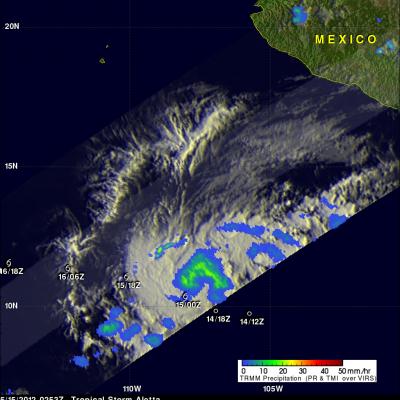
Another Tropical Cyclone Developing

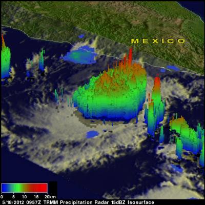
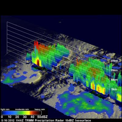
While Tropical storm Aletta is forecast to weaken and dissipate another tropical cyclone appears to be forming in the eastern Pacific south of Acapulco, Mexico. The TRMM satellite passed above this tropical disturbance (92E) on 18 May 2012 at 0957 UTC. Data captured with this pass by TRMM's Microwave Imager (TMI) and Precipitation Radar (PR) instruments were used in the rainfall analysis shown. This analysis indicates that this area contained very heavy rainfall in the northeastern quadrant of the disturbance. Some storms were producing rainfall at a rate of over 50 mm/hr (~2 inches). A 3-D

JAXA Launches GCOM-W1 Satellite

Congratulations to our partner, the Japan Aerospace Exploration Agency (JAXA), for the successful launch yesterday of the Global Change Observation Mission 1st - Water (GCOM-W1). GCOM-W1 carries the Advanced Microwave Scanning Radiometer 2 (AMSR2) which successfully deployed its antenna on orbit. AMSR2 will detect microwave radiation to measure sea surface temperature, sea surface wind speed, sea ice concentration, snow depth, soil moisture, water vapor, cloud liquid water, and precipitation. GCOM-W1 will be a part of the GPM constellation, contributing its measurements to the GPM global data

TRMM Sees Disorganized Aletta

The TRMM satellite passed almost directly above tropical storm Aletta in the eastern Pacific Ocean on 16 March 2012 at 1146 UTC. Data from TRMM's Microwave Imager (TMI) and Precipitation Radar (PR) instruments were used in the rainfall analysis shown above. Aletta's past and future positions are shown overlaid in white. Aletta looks disorganized in this orbit but some very heavy thunderstorms, producing rainfall at a rate greater than 50mm/hr (~2 inches), were located near the storm's center. TRMM's Precipitation Radar (PR) found that some thunderstorms contained very heavy rainfall with a

Tropical Storm Aletta Forms

The eastern Pacific hurricane season starts today. Just slightly ahead of schedule tropical storm Aletta formed yesterday well to the southwest of the Mexican coast. The image above uses data captured when the TRMM satellite passed above Aletta on 15 May 2012 at 0253 UTC. TRMM's Microwave Imager (TMI) instrument had a good look at the newly formed storm and showed that Aletta had a large area of light to moderate rainfall north of the storm's center of circulation. The TMI rainfall analysis is shown overlaid on an enhanced infrared image from TRMM's Visible and InfraRed Scanner (VIRS)

TRMM Sees Tropical Cyclone 19S

Tropical cyclones are more likely to form in the northern hemisphere in May so tropical cyclone 19S is a little unusual. Tropical cyclone 19S attained tropical storm intensity in the Banda Sea on 7 May 2012. 19S is expected to quickly weaken to tropical depression intensity with wind speeds of about 25 kts (~29 mph) as it moves southward into the Timor Sea north of Australia. The TRMM satellite has been useful for monitoring the development of tropical cyclones over the global tropics. TRMM flew above tropical cyclone 19S during the daylight on 8 May 2012 at 0213 UTC. A rainfall analysis from