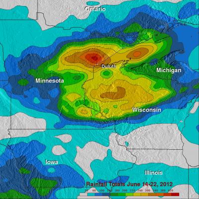
Tropical Storm Debby

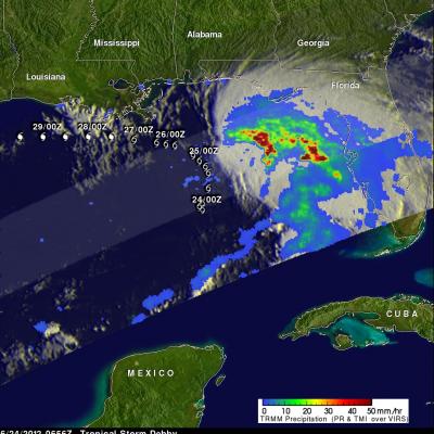
The TRMM satellite traveled directly above tropical storm Debby's location early this morning at 0656 UTC ( 2:56 AM EDT). TRMM Microwave Imager (TMI) and Precipitation Radar (PR) data from that pass shows that Debby was dropping heavy rainfall in a large area on the eastern side of the Gulf Of Mexico. Most of the powerful convective storms producing this rainfall are shown by TRMM to be located well to the northeast of Debby's center of circulation. A forecast track from the National Hurricane Center (NHC) was overlaid on the image above. It shows that Debby is expected to stengthen and travel

Strong Storms Bring Heavy Rain, Flooding to Upper Midwest

An upper-level trough of low-pressure dropping down out of the Canadian Rockies in combination with a persistent frontal boundary and high pressure over the Southeast, combined to bring about strong storms and flooding over the Upper Midwest. The storms brought the worst flooding on record to Duluth, Minnesota where as much as 10 inches of rain were reported over a 2-day period from 19th to the 20th of June, resulting in flash flooding and many washed out roads. Even the zoo was flooded. Washed out roads were blamed for 3 fatalities in nearby Wisconsin. Counter-clockwise flow around high

Tropical Storm Talim Weakens, Moves Over Japan

Both Taiwan and Southern Japan have had extreme amounts of rainfall contributed by tropical cyclones during the past week. Tropical storm Talim weakened to a tropical depression on June 18, 2012 after passing over the northern tip of Taiwan. Flooding, landslides and at least one death in Taiwan were reportedly caused by Talim. The weakening tropical depression is now affecting Japan in areas that were just drenched by Typhoon Guchol's passage. This image shows rainfall from data collected with two TRMM satellite orbits as it passed over that area. TRMM passed over on June 20, 2012 at 2308 UTC

Tropical Storm Talim's Heavy Rainfall Over Taiwan

Tropical storm Talim has produced torrential rainfall over southern Taiwan as it pumped warm moist air from the South China Sea over mountainous terrain. The TRMM satellite flew over tropical storm Talim in the Taiwan Strait on 20 June 2012 at 0140 UTC. TRMM Precipitation Radar (PR) data from this orbit shows that tropical storm Talim was dropping rainfall at a rate of almost 50mm/hr over Taiwan. TRMM data captured with that orbit shows that the most intense rainfall of over 50mm/hr (~2 inches) was located over the Strait Of Taiwan. Flash flooding and landslides are probable in southern Taiwan

Guchol's Rainfall Drenching Japan

The TRMM satellite passed above weakening typhoon Guchol on 18 June 2012 at 2322 UTC as it moved toward Japan's main island of Honshu. Guchol's past and predicted locations are shown overlaid in white. A precipitation analysis from TRMM's Microwave Imager (TMI) and Precipitation Radar (PR) instruments show that the Japanese islands of Kyushu and Shikoku were getting rainfall from Guchol at the time of that orbit. Guchol was shown by TRMM to be enhancing rainfall in parts of Japan over 500 km (~310.7 miles) from the typhoon's center.