Typhoon Haikui Heading Toward China

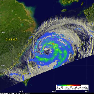
The TRMM satellite had a good view of Typhoon Haikui on August 6, 2012 at 1857 UTC as it was moving toward China. At that time Haikui was a category one typhoon on the Saffir-Simpson hurricane intensity scale with wind speeds of 65 kts (~75 mph). Data from TRMM's Microwave Imager (TMI) and Precipitation Radar (PR) instruments show bands of moderate to heavy rainfall around Haikui's large eye. TRMM PR data were also used to show a 3-D cross section through Haikui's eye. This view shows that intense rainfall (45 dBZ) was occurring in the eastern side of Haikui's eye. Typhoon Haikui weakened

TRMM Sees South Pacific Tropical Cyclone 21P

The South Pacific hurricane season normally ends in April but tropical cyclone 21P has developed in the South Pacific Ocean between Papua New Guinea and the Solomon Islands. The center of the tropical cyclone was directly beneath the TRMM satellite when it passed over on 28 June 2012 at 2225 UTC (~8:25 AM Local time). A rainfall analysis using data from TRMM's Microwave Imager (TMI) and Precipitation Radar (PR) instruments shows that the tropical cyclone, although small, was well organized and contained some intense convective storms dropping rainfall at a rate of over 50mm/hr (~2 inches). A 3

Debby's Remnants Will Slightly Affect Bermuda

The remnant low pressure center from tropical storm Debby is predicted to kick up winds to gale force and cause a few showers today as it passes to the northwest of Bermuda. The TRMM satellite passed over the low early this morning at 0717 (4:17 AM ADT). TRMM Microwave Imager (TMI) and Precipitation Radar (PR) data show that Debby's remnant low contained a few light to moderate showers. A 3-D view using TRMM PR data shows that the most powerful of these storms were only reaching heights of about 10km (~6.2 miles).

Tropical Storm Debby Drenches Florida

Even though it never became more than a tropical storm, the residents of northern and central Florida will remember Debby. Debby, which formed as a tropical storm on the 23rd of June 2012 in the central Gulf of Mexico, took three full days to reach the Big Bend of Florida just 350 miles away. Although the center didn't make landfall until around 5 pm on the afternoon of the 26th when it crossed the coast near Steinhatchee, Florida, Debby's effects were felt well away from the center. Most of the rain and weather associated with Debby were well to the north and east of the center over Florida

Tropical Storm Debby Threatens Florida Gulf Coast

Tropical Storm Debby formed on the 23rd of June 2012 in the central Gulf of Mexico, becoming the earliest 4th named storm on record. Debby began as an area of low pressure that moved out of the northwestern Caribbean and into the Gulf. After forming on the afternoon of the 23rd, Debby has moved very slowly under the influence of weak steering currents. Debby drifted ever so slowly northward on the night of the 23rd before turning northeast later on the morning of the 24th towards the northeast Gulf Coast of Florida. Despite its slow forward progress and lack of intensification, Debby has