This excerpt from the NASA Earth Observer publication provides and in-depth summary of the Midlatitude Continental Convective Clouds Experiment (MC3E), which took place from April 22nd - June 6th 2011 in central Oklahoma. The overarching goals of the field effort were to provide a complete three-dimensional characterization of precipitation microphysics in the context of improving the reliability of GPM precipitation retrievals over land, and to advance understanding of the primary physical components that form the basis for models that simulate convection and clouds.
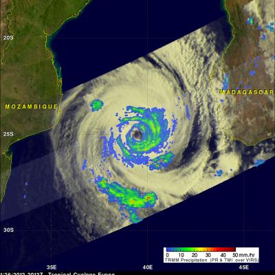
The TRMM satellite saw directly into the eye of tropical Cyclone Funso on 26 January 2012 at 2013 UTC. TRMM Microwave Imager (TMI) and Precipitation Radar (PR) rainfall shows that frequent moderate to heavy rainfall was located in bands around Funso. TRMM PR data show that the tallest storm towers , reaching to about 12km (~7.5 miles), were located in a feeder band southwest of the eye.
Thousands of people were asked to evacuate recently as parts of northern and eastern Australia felt the effects of heavy rains brought about by the summer monsoon. Though not expected to be as bad as last year, when dozens of people were killed and tens of thousands of homes were flooded, the recent heavy rains have led to flash flooding and landslides in Queensland and caused rivers to overflow their banks in New South Wales. The monsoon plays a prominent role in the annual rainfall cycle over Australia. A monsoon is a seasonal phenomenon wherein an area of low pressure forms over a large