Monsoon Trough Continues to Drench Northeastern Australia

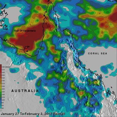
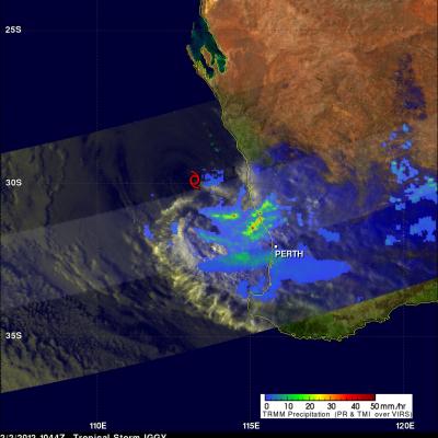
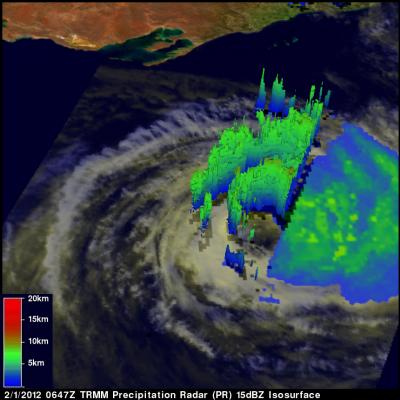
Low pressure centers associated with a summer monsoon trough have repeatedly drenched Australia from central Queensland to northern New South Wales. The clockwise rotation of these low pressure centers have continued to pump warm moist air from the Coral Sea over these areas resulting in severe flooding. Thousands of Australians have been displaced by this flooding. The current La Nina conditions are predicted to continue causing heavy rainfall over northeastern Australia. Data from the TRMM satellite are used to calibrate rainfall data merged from various satellite sources. This TRMM-based

Iggy Rainfall Hits Australia

On 2 February 2012 at 1044 UTC the TRMM satellite again saw weakening tropical storm IGGY as it was approaching the coast of southwestern Australia. Data from TRMM's Microwave Imager (TMI) and Precipitation Radar (PR) instruments showed that bands of heavy rainfall measuring over 50mm/hr (~2 inches) were hitting coastal areas northwest of Perth, Australia. A red tropical storm symbol shows where Iggy's center was located.

Tropical Cyclone Iggy

The TRMM satellite passed above tropical storm Iggy on 1 February 2012 at 0647 UTC as the storm was heading toward the coast of southwestern Australia. Iggy was briefly categorized as a category 1 tropical cyclone on the Saffir-Simpson scale but is predicted to be a weak tropical storm with winds of about 35kts (~40 mph) when it moves over the Australian coast. Iggy's past and forecast locations are shown with appropriate white tropical cyclone symbols on the image above. TRMM data revealed that Iggy had a large area of moderate to heavy rainfall south of the center of circulation. TRMM's

Three Days, Two Snowstorms

Joe Munchak is a scientist at Goddard Space Flight Center who specializes in remote sensing of snow. This week he is at the CARE site in Ontario as one of the operations scientists for the GCPEx ground validation. It’s been a relatively eventful few days here in Barrie, Ontario, with two coordinated air-ground campaigns over the past three days. I was actually driving to Barrie from my home in Maryland during the first event (January 28th), and got to experience some lake effect snow bands first-hand in northern Pennsylvania on my way up. These were very narrow, only a few miles wide, but