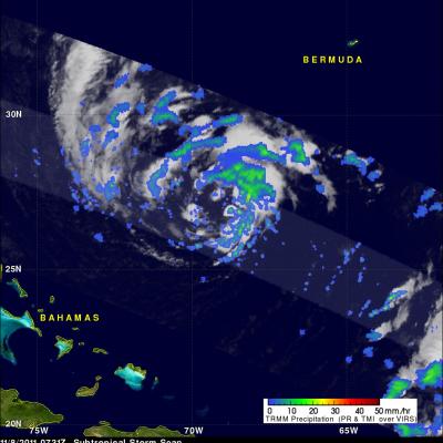
Tropical Storm Kenneth

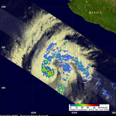
The TRMM satellite had a good view of tropical storm Kenneth in the eastern Pacific Ocean when it passed above on 21 November 2011 at 0510 UTC (20 November 2011 9:10 PM PST). The National Hurricane Center (NHC) upgraded Kenneth to a hurricane on 21 November 2011 at 1500 UTC (7:00 AM PST) after determining that a ragged eye was forming. The image on the right shows a rainfall analysis derived from TRMM's Microwave Imager (TMI) and Precipitation Radar (PR) instruments. TMI data show that heavy rainfall was occurring around the center of Kenneth's circulation.

TRMM Sees Deadly Tornadic Thunderstorms

Tornadoes are expected to accompany severe storms in the springtime in the U.S., but this time of year they also usually happen. When a line of severe thunderstorms associated with a cold front swept through the U.S. southeast on Nov. 16, TRMM collected rainfall data on the dangerous storms from space. TRMM's Precipitation Radar (PR) data was used to show the line of severe thunderstorms in 3-D. The line of storms were pushing through North and South Carolina on Nov. 16, 2011. Strong updrafts had pushed precipitation within some of these storms to heights of 15km (9.3 miles). Credit: SSAI/NASA

TRMM PR Slices Through Sean

The TRMM satellite had a good look at tropical storm Sean when it flew over on 10 November 2011 at 0541 UTC (00:41 AM EST). TRMM's Precipitation Radar (PR) data were used in the image above to show a 3-D cross section through Sean. TRMM's PR revealed that heights of storms in the edge of Sean's center of circulation were reaching to about 11km (~6.8 miles). Radar Reflectivity values of up to 46.0 dBZ found in these storms also showed that rainfall was heavy in that area. The "top down" satellite view above shows that those storms in Sean's northwestern quadrant were the most powerful. The rest

Tropical Depression Near Oman Dissipates

The Joint Typhoon Warning Center (JTWC) issued it's last warning on dissipating tropical depression 04W in the Arabian Sea on 9 November 2011 at 1500 UTC. A rainfall analysis from TRMM data collected with a pass over 04A on 9 November 2011 at 1530 UTC is shown here. Data from TRMM's Microwave Imager (TMI) and Precipitation Radar (PR) show that heavy rainfall was extending from 04A's location in the Arabian Sea north-eastward toward Pakistan.

TRMM Sees Subtropical Storm Sean

The National Hurricane Center (NHC) upgraded a low pressure center in the Atlantic Ocean to subtropical storm Sean at 0900 UTC ( 4:00 AM EDT). The TRMM satellite flew directly above Sean a little earlier on 8 November 2011 at 0731 UTC ( 2:31 AM EDT) collecting data used in the precipitation analyses shown. TRMM Precipitation Radar (PR) data in the 3-D display above show that scattered moderate storms within Sean were reaching maximum heights of only about 11km (~6.8 miles). The "top down" view on the right above shows that Sean was well organized but most rainfall was of low to moderate