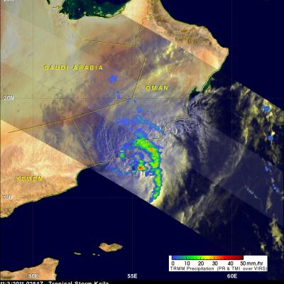
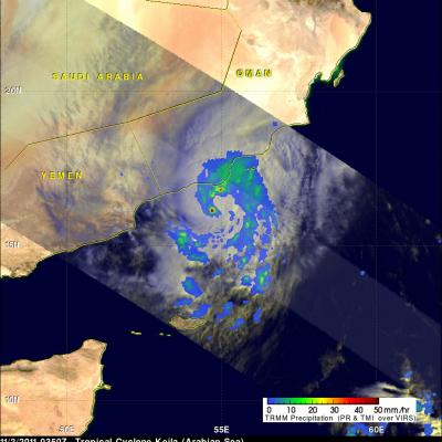
Another Possible Tropical Cyclone Approaches Oman

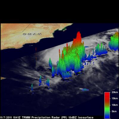
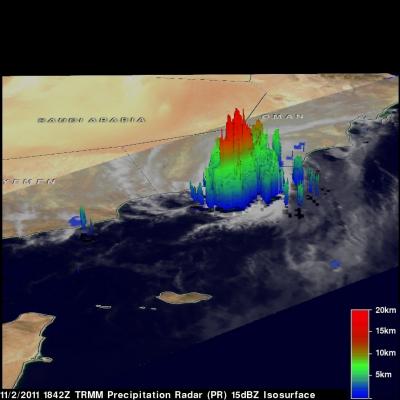
On November 2011 at 1541 UTC the TRMM satellite passed over another stormy area heading toward Oman from the Arabian sea . Another tropical cyclone may be forming in this area less than a week after deadly tropical storm Keila hit Oman. A rainfall analysis from TRMM's Microwave Imager (TMI) and Precipitation Radar (PR) is shown in the image above. Rainfall derived from PR data, shown in a lighter shade, reveals that an area of extremely heavy rainfall was located in the center of this stormy area. TRMM's PR data were again used to show the 3-D structure of this stormy area. Some of these very

Scientists Gather in Denver for the 2011 PMM Science Team Meeting

Over 150 scientists from 10 different countries are meeting in Denver, Colorado, to discuss rain and snow and how to measure them from space. Only once a year members of the Precipitation Measurement Missions (PMM) Science Team come together to discuss the science surrounding both the current Tropical Rainfall Measuring Mission (TRMM) and the upcoming Global Precipitation Measurement (GPM) mission that will launch in 2014. The four-day meeting opened on Monday, November 7th with a focus on the mission status for both TRMM and GPM, and continues with breakout sessions, scientific presentations

TRMM Views Deadly Storm

Tropical storm Kelia caused the reported deaths of at least 11 people when it came ashore in Oman on Thursday 3 November 2011. TRMM's Microwave Imager (TMI) had a good early morning view of Keila on 3 November 2011 at 0254 UTC. The TMI rainfall analysis from these data was overlaid on a sunlit visible and infrared image from TRMM's Visible and InfraRed Scanner (VIRS). This rainfall analysis shows a large band of moderate to heavy rainfall wrapping around the eastern side of the storm and drenching coastal Oman.

TRMM Sees Weakening Tropical Storm Keila

The TRMM satellite again flew over tropical storm Keila in the Arabian Sea on November 2, 2011 at 1842 UTC. Data received with that orbit shows that although Keila was weakening it was still producing some very powerful storms off the coast of Oman. A rainfall analysis from TRMM's Microwave Imager (TMI) and Precipitation Radar (PR) indicates that these storms were dropping rain at a rate of over 50mm/hr (~2 inches). TRMM PR data were used in the image above to show the 3-D vertical structure of those storms. Some extremely powerful storms in the band of rainfall off the coast of Oman were

Tropical Storm Keila In The Arabian Sea

The TRMM satellite passed directly above a recently formed tropical cyclone in the Arabian Sea on November 2, 2011 at 0350 UTC. An analysis of rainfall from TRMM's Microwave Imager (TMI) and Precipitation Radar (PR) instruments is shown in the image on the upper left. TRMM data shows that rainfall rates with tropical storm Keila ranged from light to moderate along the south-eastern coast of Oman. Moderate to heavy rainfall was revealed to be spiraling into Keila's center of circulation in the Arabian Sea near the southeastern coast of Oman. The image above is a rendering that shows Keila's