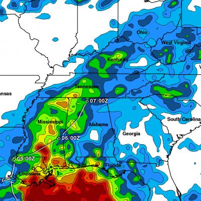
Tropical Storm Lee Joins with Frontal System to Soak the Eastern US

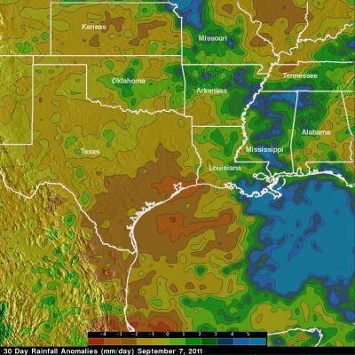
After forming in the north central Gulf of Mexico, Tropical Storm Lee came ashore over south central Louisiana on the morning of Sunday September 4th, 2011. Over the next two and a half days, the slow-moving storm worked its way across central Louisiana and central Mississippi and into northern Alabama, dumping heavy rains along the way. The primary mission of the Tropical Rainfall Measuring Mission or TRMM satellite is to measure rainfall over the global Tropics using a combination of passive microwave and active radar sensors. For expanded coverage, TRMM can be used to calibrate rainfall

TRMM Sees Developing Tropical Storm Nate

The TRMM satellite flew over the latest tropical cyclone to form in the Atlantic Ocean basin on 7 September 2011 at 1812 UTC (2:12 PM EDT). This TRMM pass was a few hours before the National Hurricane Center (NHC) named this low pressure center in the Bay Of Campeche tropical storm Nate. Data from TRMM's Precipitation Radar (PR) shows that the forming tropical cyclone had areas of heavy convection with storm tops reaching to heights of about 14km (~8.7 miles) south of Nate's center of circulation.

Extreme Rainfall from Tropical Storm Lee

The rainfall analysis above is from TRMM calibrated precipitation estimates called Multi-satellite Precipitation Analysis (MPA). This product was developed by the precipitation research team in the Laboratory for Atmospheres at NASA Goddard Space Flight Center and uses satellite data collected in "real time"(3B42 ). This preliminary analysis shows the estimated total rainfall measured for the period from 30 August to 6 September 2011 and includes rainfall from other sources including tropical storm Lee. Tropical storm Lee has been dropping heavy rain since moving over land from the Gulf Of

TRMM Sees TD13 Forming

The TRMM satellite viewed the thirteenth tropical depression of the Atlantic hurricane season on Thursday 1 September 2011 at 1309 UTC (9:09 AM EDT) when it was still forming. The National Hurricane Center (NHC) has predicted that TD13 will intensify and become a tropical storm (Lee) today. The tropical storm is predicted by the NHC to slowly move toward the northwest and cause heavy rainfall over the states along the northern Gulf Of Mexico's coast. One area of heavy rainfall in the middle of the Gulf Of Mexico was in the center of the area viewed by TRMM's Precipitation Radar (PR). Some of

Tropical Storm Talas Approaches Japan

Tropical storm Talas was seen by the TRMM satellite approaching the main islands of Japan on 1 September 2011 at 0416UTC (~1:15 PM local time). This daylight TRMM pass shows that Talas had a very large nearly clear eye with large bands of intense thunderstorms located far from the storm's center. Talas is predicted travel over the main islands of japan in the next 36 hours.