Philippe Becomes a Hurricane

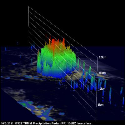
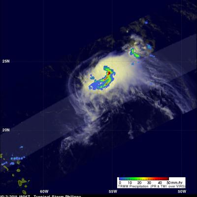
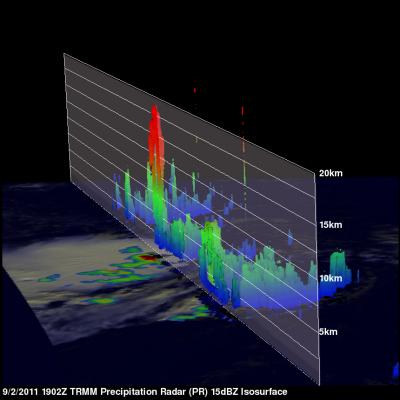
The National Hurricane Center (NHC) upgraded Philippe to a hurricane at 1500 UTC (11 AM EDT) on Thursday 6 October 2011. Earlier TRMM Microwave Imager (TMI) data from the 6 October 2011 at 0024 UTC view shows that tropical storm Philippe's center of circulation had become better defined with an eye wall forming. The TRMM satellite also had an excellent look at Philippe earlier on Wednesday 5 October 2011 at 1752 UTC (1:52 PM EDT). TRMM's Precipitation Radar (PR) scanned directly over Philippe and revealed that Philippe had bands of intense rainfall around the southeast side of the center of

Tropical Storm Nalgae Weakens

was a tropical storm and weakening rapidly when the TRMM satellite saw it on 4 October 2011 at 0624 UTC. This rainfall analysis from TRMM's Microwave Imager (TMI) and Precipitation Radar (PR) shows only scattered areas of light to moderate rainfall were present with Nalgae as it moved into the Gulf Of Tonkin west of Hainan. Click here to see earlier TRMM information about Nalgae.

Philippe's Strength Persists

Philippe was still a tropical storm when the TRMM satellite passed above on 3 October 2011 at 1806 UTC (2:06 PM EDT) but the National Hurricane Center (NHC) predicts that the storm may become a hurricane in a couple days. TRMM's TMI and PR data show that bands of powerful convective thunderstorms were still dropping rain at a rate of over 50mm/hr (~2 inches) near the center of the storm.

Tropical Storm Philippe Shows Signs Of Life

Tropical Storm Philippe, located in the central Atlantic Ocean, has shown signs of strengthening. The TRMM satellite obtained those data used in the above image when it passed over on 2 October 2011 at 1902 UTC ( 3:02 PM EDT). TRMM's Microwave Imager (TMI) and Precipitation Radar (PR) derived rainfall showed that Philippe had powerful thunderstorms in the north-central part of the storm dropping rainfall at a rate over 50 mm/hr (~2 inches). TRMM's PR was used in the image below show a vertical cross section (slice) through one of these thunderstorms. This image shows that one of these tall

Nalgae Exits The Philippines and Heads Toward China

The TRMM satellite had a good look at typhoon Nalgae on 2 October 2011 at 0637 UTC after it became the second typhoon in a week to hit the Philippines. Nalgae was in the middle of the South China Sea headed toward southern Hainan. In this image a rainfall analysis from TMI and PR data was overlaid on a combination Infrared and Visible image from TRMM's Visible and InfraRed Scanner (VIRS) instrument. See earlier information about Nalgae