TRMM Sees CAT 4 Ophelia

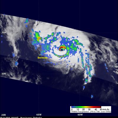
Ophelia was a very powerful category four hurricane on the Saffir-Simpson scale with winds of over 115 kts (~132 mph) when TRMM passed over head on 2 October 2011 at 0049 UTC. The Infrared image from that orbit shows that Ophelia had a small clear eye as it was passing well to the east of Bermuda. TRMM's Microwave Imager (TMI) and Precipitation Radar (PR) data revealed that heavy rainfall was located in the northern side of the eye wall.

Typhoon Nalgae Menaces the Philippines

The Philippines is still reeling from the devastation caused by typhoon Nesat as another typhoon called Nalgae approaches from the east. Nalgae formed on 27 October 2011 near the same area of the western Pacific Ocean where Nesat originated. The TRMM satellite had a daylight look at Nalgae (known as Quiel in the Philippines) on 30 September 2011 at 0653 UTC. TRMM's Microwave Imager (TMI) and Precipitation Radar (PR) data shows heavy rainfall near Nalgae's eye. The total area of rainfall isn't as extensive as it was with typhoon Nesat at this distance from the Philippines. Click here to see a

Ophelia Becomes a Hurricane

The TRMM satellite saw tropical storm Ophelia on 29 September 2011 at 2008 UTC ( 4:08 PM EDT) shortly before the storm was upgraded to a hurricane by the National Hurricane Center (NHC). An analysis of rainfall from TRMM's Microwave Imager (TMI) and Precipitation Radar (PR) data shows that Ophelia was developing an eye with powerful thunderstorms located in the northwestern side of the forming eye wall. On Friday 30 October 2011 Ophelia further intensified to become a powerful category three hurricane on the Saffir-Simpson scale with winds of 100kts (~115 mph). The NHC has predicted that this

Deadly Typhoon Nesat Hits The Philippines

Powerful typhoon Nesat (known locally as Pedring) came ashore in the Philippines on Tuesday September 27, 2011 causing the deaths of at least 33 people. Nesat was classified as a category three typhoon on the Saffir-Simpson scale with winds of 105 knots (~121 mph) before hitting the island of Luzon. The rainfall analysis above is the result of a TRMM-calibrated merged global Multi-satellite Precipitation Analysis (MPA) performed at Goddard Space Flight Center (GSFC). These MPA rainfall total estimates were for the period from 24-29 September 2011. This analysis indicates that the highest