Neoguri A Little Weaker

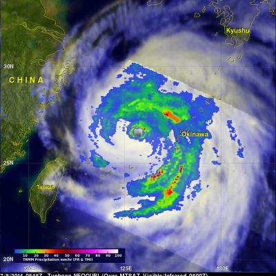
TRMM satellite had another good view of typhoon NEOGURI on July 8, 2014 at 0545 UTC. With wind speeds of 110 kts (about 127 mph) NEOGURI had weakened to a strong category three typhoon. A rainfall analysis from TRMM's Microwave Imager (TMI) and Precipitation Radar (PR) is shown overlaid on a MTSAT Visible/Infrared image from 0600 UTC. Rainfall was measured by TRMM PR falling at a rate of over 117 mm (about 4.6 inches) per hour in a rain band affecting Okinawa. A simulated 3-D view (from the east) shows NEOGURI's rainfall structure at the time of this TRMM satellite pass. Powerful thunderstorms

GPM Dissects Hurricane Arthur

Submitted by JacobAdmin on
Video Embed

The Global Precipitation Measurement mission's Core Observatory flew over Hurricane Arthur five times between July 1 and July 6, 2014. Arthur is the first tropical cyclone of the 2014 Atlantic Hurricane season. It formed as a tropical storm on Tuesday, July 1 and reached maximum intensity as a Category 2 hurricane on July 4, disrupting some coastal U.S. Independence Day celebrations. This visualization is taken from the flyover on July 3, 2014 with Hurricane Arthur just off the South Carolina coast.

Powerful Hurricane Arthur Hits North Carolina

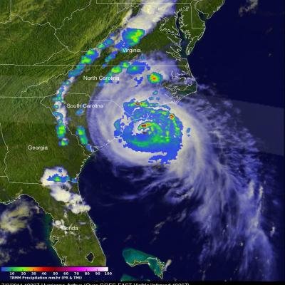
Hurricane Arthur battered North Carolina after coming ashore late last night at 0315 UTC (11:15 PM EDT). The TRMM satellite flew directly over Arthur on July 3, 2014 at 1922 UTC ( 3:22 PM EDT) as the hurricane was becoming increasingly more powerful. An analysis of rainfall from TRMM's Microwave Imager (TMI) and Precipitation Radar (PR) instruments was overlaid on a 1926Z GOES-EAST Visible/Infrared image. Intense bands of thunderstorms north of Arthur's well defined eye were revealed by TRMM to be dropping rainfall at a rate of over 98.4 mm ( about 3.9 inches) per hour. One of the TRMM

TRMM Sees Arthur Intensifying

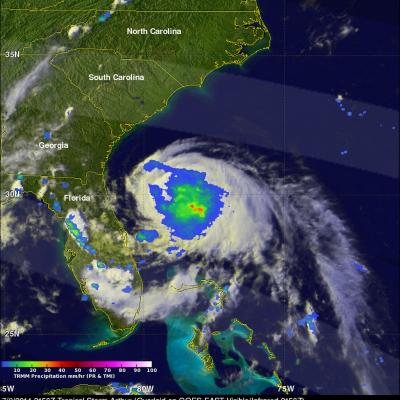
Tropical storm Arthur intensified and was upgraded to a hurricane by the National Hurricane Center (NHC) early this morning. The TRMM satellite flew above the intensifying tropical storm on July 2, 2014 at 2156 UTC (7:56 PM EDT). At that time TRMM found that Arthur hadn't formed an eye but had heavy rain near the center of a well defined circulation. Rainfall derived from TRMM's Microwave Imager (TMI) and Precipitation Radar (PR) is shown overlaid on a GOES-EAST Visible/Infrared image collected at the same time as the TRMM pass.

TRMM Sees New Tropical Storm Arthur

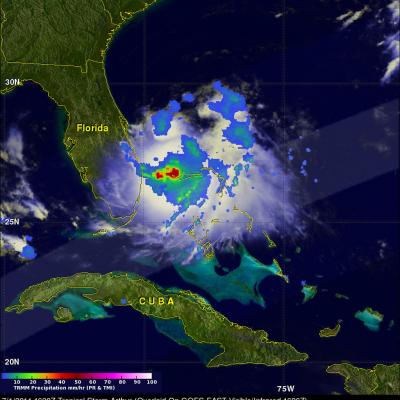
The TRMM satellite had a good daylight look at tropical storm Arthur on July 1, 2014 at 1620 UTC (12:20 PM EDT) less than two hours after it was upgraded from a tropical depression. Rainfall from TRMM's Microwave Imager (TMI) and Precipitation Radar (PR) data are shown overlaid on a GOES-EAST infrared/visible image collected at 1626 UTC (12:26 PM EDT). The location of very heavy rainfall around Arthur's center was shown using TMI data. TRMM PR data sliced through the southern half of the tropical storm. A 3-D view (from the west) using those data is shown above. Radar reflectivity values