Arthur Becomes First Atlantic Tropical Storm

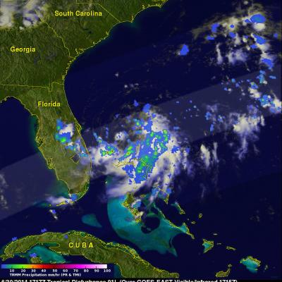
A tropical disturbance east of Florida's coast became better organized and was upgraded to a tropical depression by the National Hurricane Center (NHC) on June 30, 2014 at 11:00 PM EDT (July 1, 2014 at 0300 UTC). On July 1, 2014 at 1100 AM EDT (15:00 UTC) the NHC upgraded tropical depression one to tropical storm Arthur. The TRMM satellite had an excellent view of the forming tropical depression (TD01) on June 30, 2014 at 1717 UTC (1:17 PM EDT). Intense thunderstorms were shown by TRMM to be wrapping around the southern side of the low pressure center. TRMM's Precipitation Radar (PR) revealed

GPM Data Release Schedule Announced

The GPM Core Observatory satellite was successfully launched on February 27th, 2014. Data from the GPM Microwave Imager (GMI) and Dual-frequency Precipitation Radar (DPR) have the following release schedule. All data are freely available through the NASA's Precipitation Processing System at http://pps.gsfc.nasa.gov June 16th – GMI Level 1 Brightness Temperature data have been released. This includes GMI instrument swath data. July 14th – GMI Level 2 Precipitation Rate data will be released. This includes precipitation rates estimated using the Goddard Profiling algorithm (GPROF14) and are

A Week of Violent Weather And Heavy Rainfall

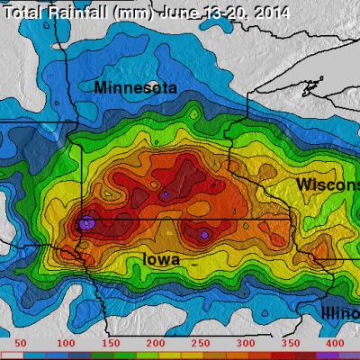
Over the past seven days stormy weather has spawned tornadoes and dropped extremely heavy rainfall in the Northern Plains and the Great Lakes states. This deluge has caused flooding in South Dakota, Minnesota, Iowa, Wisconsin and Illinios. There have been concerns about the Mississippi, Big Sioux and Rock River Rivers escaping their banks. For more than sixteen years rainfall has been monitored by the TRMM-based, near-real time Multi-satellite Precipitation Analysis (TMPA) . These products have been developed at the NASA Goddard Space Flight Center by the precipitation research team. (TMPA)

First GPM Data Now Public

The first set of data from the Global Precipitation Measurement mission is now available to the public. The data set consists of GPM Microwave Imager instrument observations, called brightness temperatures. Brightness temperatures are a measurement of naturally occurring energy radiated, in this case, by precipitation particles like raindrops or snowflakes. Other data sets, like the rain rate information, will be released later this summer. By themselves, however, the brightness temperatures convey valuable data on the location and structure of storm systems – including tropical cyclones and

Heavy Rain & Tornadoes

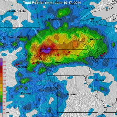
Tornadoes killed two people yesterday in Pilger, Nebraska. Tornadoes were reported with violent weather that also hit the states of North Dakota, Iowa and Wisconsin. Heavy rainfall with this extreme weather was monitored with the TRMM-based, near-real time Multi-satellite Precipitation Analysis (TMPA) at the NASA Goddard Space Flight Center. An analysis of TMPA rainfall totals is shown here for the seven days from June 10-17, 2014. This analysis indicated that the highest rainfall totals for the period (light purple) were greater than 300 mm (about 11.8 inches) in northwestern Iowa. Locations