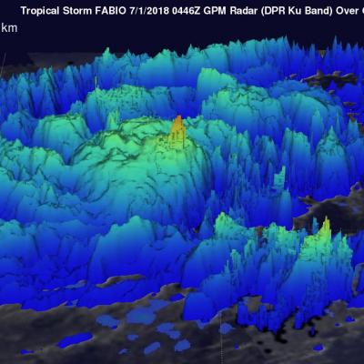
GPM Views Hurricane Fabio off the Coast of Mexico

View fullscreen in STORM Event Viewer Off the southwest coast of Mexico, Hurricane Fabio has winds approaching 80 knots in this overflight, with a clear eye in the microwave and radar imagery. Fabio is expected to intensify over the next 24-48 hours, but will remain over open waters throughout its lifespan, eventually dissipating. Want to see other events in STORM Event Viewer? Have questions about the technology behind it? Contact the PPS Visualization Team The Dual-frequency Precipitation Radar and GPM Microwave Imager data are products of a joint mission between NASA and JAXA. If you are

Eastern Pacific Tropical Storm Fabio Examined With GPM Satellite

NASA's GPM core observatory satellite flew above tropical storm FABIO in the eastern Pacific Ocean south of Mexico on June 30, 2018 at 10:46 PM MDT (July 1, 2018 at 0446 UTC). FABIO has continued to intensify since then and the National Hurricane Center (NHC) predicts that the tropical storm will become a hurricane later today. FABIO is then expected to become a major hurricane on July 3, 2018 and reach it's peak intensity with wind speeds of about 105 kts (121 mph). Rainfall measurements by GPM's Microwave Imager (GMI) and Dual-Frequency Precipitation Radar (DPR) instruments showed that FABIO

Tropical Storm Prapiroon Probed By GPM Core Observatory Satellite

Tropical depression 09W was located in the northwest Pacific east of the Philippines when it was upgraded today to tropical storm PRAPIROON. The tropical storm is in a favorable environment for intensification. Vertical wind shear is low above the tropical cyclone and sea surface temperatures are warm below. NASA's GPM core observatory satellite had a good view of tropical storm PRAPIROON on June 29, 2018 at 0246 UTC. PRAPIROON was just barely a tropical storm with maximum sustained wind speeds estimated at about 35 kts (40.3 mph). GPM's Microwave Imager (GMI) and Dual-Frequency Precipitation

TKIO announcement - PPS Announcing a New tkio- 3.80.44 Release

PPS is releasing version 3.80.44 build of the PPS TKIO toolkit using the 14.0.1 Fortran compiler for GPM. As detailed in our earlier announcement that you received on Thursday, June 28th, 2018, titled; "PPS is Reprocessing TRMM PR Data as TRMM GPM, Version 06A HDF5 products in Early July 2018" This is the version of the PPS I/O Toolkit that will be used for these radar products. The release notes are in this directory and are also attached to this Email: ftp://gpmweb2.pps.eosdis.nasa.gov/pub/PPStoolkit/GPM/tkio-3.80.44/ The tar file can be found at: ftp://gpmweb2.pps.eosdis.nasa.gov/pub

PPS is Reprocessing TRMM PR Data as TRMM GPM, Version 06A HDF5 products in Early July 2018

The TRMM Version 7 Precipitation Radar (PR) products will be superseded by new GPM era products with a reprocessing that will generate TRMM retrievals from the beginning of the TRMM mission to the end of data collection using a single frequency retrieval algorithm similar to that used for GPM Ku. This reprocessing will begin in early July, 2018. Retrievals previously available in the TRMM Version 7 products 2A21, 2A23, 2A25, and 3A25 will be available in the new 2APR and 3PR products. Note that these new GPM era products are in HDF5 format and similar in structure to those used for GPM DPR