Texas' Heavy Rain Measured By IMERG

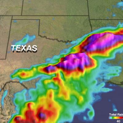
Over the past few days a slow moving frontal system moving through the Southwest produced heavy rain resulting in flooding and mudslides over central Texas. One person was reported swept away by flood water near Fort Hood Texas. NASA's Integrated Multi-satellitE Retrievals for GPM (IMERG) data were used to provide an estimate of rainfall accumulation over Texas. From April 10-12, 2017 IMERG estimates indicate that over 8 inches (203 mm) of rain fell in the area from central Texas through northern Louisiana.

GPM Catches Nor'easter over New England

Submitted by JacobAdmin on
Video Embed

At the time of the Global Precipitation Measurement (GPM) Core Observatory overpass (April 1, 2017, 0550 UTC), the storm's center of low pressure was south of Long Island. At the mid-levels of the atmosphere, the circulation was centered over northeast Pennsylvania. This led to a classic overrunning, warm conveyor setup, which happened when the counterclockwise low level flow drew in cold air out of the north/northeast (hence "Nor'easter") from Canada.

GPM Observes Tropical Cyclone Forming North of Australia

The GPM Core Observatory satellite flew directly above a forming tropical cyclone in the Timor Sea northeast of Darwin, Australia on April 10, 2017 at 1146 UTC. Data collected by GPM's Microwave Imager (GMI) and Dual-Frequency Precipitation Radar (DPR) instruments showed that convective storms within the tropical low contained very heavy rainfall. GPM's DPR (Ku Band) data revealed that a line of intense storms west of the Bathurst and Melville islands was dropping rain at a rate of over 161 mm (6.3 inches) per hour. A 3-D examination of the forming tropical cyclone's cloud tops showed that

Deadly Flooding Rains Near Mocoa, Colombia Measured By IMERG

Late Friday night and Saturday morning flash flooding and mudslides killed over 250 people in Mocoa, Colombia. Extremely intense storms added heavy rain to water logged terrain around Mocoa. Water from this heavy rainfall converged into a river that runs close to Mocoa causing it to overflow it's banks with deadly results. Integrated Multi-satellitE Retrievals (IMERG) data were used to estimate the amount of rain that fell near Mocoa, Colombia during the seven day period from March 26 to April 2, 2017. IMERG indicates that area rainfall totals during the week were frequently greater than 80 mm

Tropical Cyclone Caleb's Rainfall Revealed By GPM

Tropical cyclone Caleb formed today in the South Indian Ocean southwest of the Indonesian Island of Sumatra. The GPM core observatory satellite had a fairly good view of the the newly formed tropical cyclone when it flew over on March 23, 2017 at 0756 UTC. The satellite's Microwave Imager (GMI) revealed the locations of rainfall within the tropical cyclone. Rainfall measurements derived from the GMI showed that convective storms's were dropping rain at a rate of almost 84 mm (3.3 inches) per hour on Caleb's eastern side. The Joint Typhoon Warning Center (JTWC) predicts that tropical cyclone