Extreme Weather

Extreme weather news and updates.

GPM Examines Forming Tropical Storm Nate (TD16)

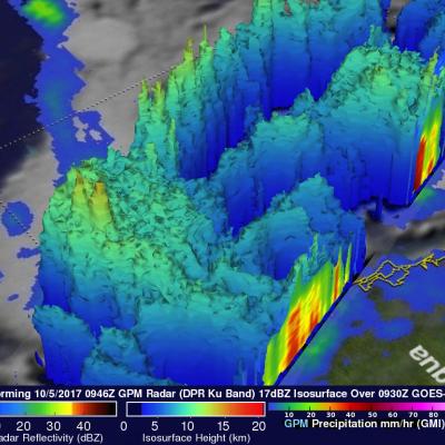
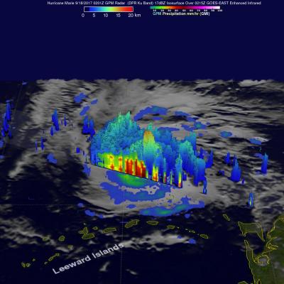
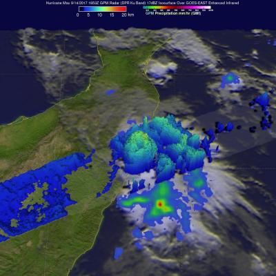
The GPM core observatory satellite passed above forming tropical storm Nate (TD16) on October 5, 2017 at 5:46 AM EDT (0946 UTC). TD16 was located in the western Caribbean near the coast of Nicaragua with winds of about 34.5 mph (30 kts). Data received by GPM's Microwave Imager (GMI) and Dual-Frequency Precipitation Radar (DPR) shows bands of rain producing heavy rainfall East of TD16's center of circulation. Downpours in the Caribbean Sea East of Nicaragua were measured by GPM's Radar (DPR Ku Band) dropping rain at a rate of over 6.4 inches (162 mm) per hour. This close-up 3-d cross section

GPM Views Weakening Hurricane Maria

Hurricane Maria has significantly weakened from the powerful category four hurricane that devastated Puerto Rico. The GPM core observatory satellite flew over Maria on September 25, 2017 at 9:28 PM EDT (September 26, 2017 at 0128 UTC). This informative GPM pass showed that the western side of the hurricane was drier and contained much less precipitation than the eastern side. GPM's Dual-Frequency Precipitation Radar (DPR) scanned directly through the center of Maria's eye and showed that there were only light to moderate rain showers around the hurricane's center. DPR found a few convective

GPM Shows Hurricane Maria North Of Turks And Caicos Islands

On September 23, 2017 at 8:12 AM AST (1212 UTC) the GPM core observatory satellite had another excellent view of hurricane Maria. The early morning view showed Maria heading north of the Bahamas after battering the Turks and Caicos Islands. Maria had maximum sustained wind speeds of about 121mph (105 kts). Estimates of hourly rainfall at the ocean's surface were derived from GPM's Microwave Imager (GMI) and Dual-Frequency Precipitation Radar (DPR) data. Multiple intense rainfall bands are shown rotating around the western side of the hurricane. Rain was found falling at a rate of over 6.57

Hurricane Maria's Torrential Rainfall Measured By IMERG

Hurricane Maria has caused catastrophic flooding in Puerto Rico. Extreme flooding was reported in the streets of San Juan, the capital of Puerto Rico. The National Weather Service issued flash flood warnings for the entire island. Hurricane Maria has now moved to the northwest of Puerto Rico but is still expected to contribute to rainfall over the island on Friday. Feeder bands are transporting rain over Puerto Rico and the Dominican Republic even as the hurricane moves toward the Turks and Caicos islands. NASA's Integrated Multi-satellitE Retrievals for GPM (IMERG) data were used to estimate
GPM Sees Hurricanes Maria and Jose
GPM passed over both Hurricane Maria and Hurricane Jose on September 18th, 2017. As the camera moves in on the Maria, DPR's volumetric view of the storm is revealed. A slicing plane moves across the volume to display precipitation rates throughout the storm. Shades of green to red represent liquid precipitation extending down to the ground. The Global Precipitation Measurement (GPM) mission shows the rainfall distribution for two major storms churning in the Atlantic and Caribbean basins. The visualization shows Hurricane Jose as it continues to slowly move northward off the US East Coast east...

GPM Satellite Looks At Hurricane Maria's Rainfall

Early this morning (after 6 AM local time) hurricane Maria made landfall near Yabucoa, Puerto Rico as a strong category four hurricane. Maximum sustained winds in the hurricane were reported to be 149.5 mph (130 kts) as Maria moved toward San Juan, Puerto Rico. Powerful convective storms within the hurricane were also dropping heavy rainfall. The GPM core observatory satellite collected data as it passed above hurricane Maria earlier on September 19, 2017 at 9:51 PM AST (September 20, 2017 0151 UTC). This rainfall analysis was derived from GPM's Microwave Imager (GMI) and Dual-Frequency

Jose Continues to Meander off the East Coast

Jose has been a named storm for nearly two weeks now as it continues to slowly move northward off the US East Coast east of the Outer Banks of North Carolina. At one time, Jose was a powerful category 4 border line category 5 storm with maximum sustained winds reported at 155 mph by the National Hurricane Center back on the 9th of September as it was approaching the northern Leeward Islands. Jose passed northeast of the Leeward Islands as a category 4 storm on a northwest track and then began to weaken due to the effects of northerly wind shear. Jose then made a counterclockwise loop about

Hurricane Maria Threatening The Leeward Islands

Intensifying hurricane Marie is on a path that is predicted to impact the Leeward Islands. Hurricane Irma caused death and wide spread destruction there less than two weeks ago. Very powerful convective storms and multiple lightning strokes within Maria have been cited as proof that Maria is an energetic intensifying hurricane. The GPM core observatory satellite had an excellent view of hurricane Maria when it passed almost directly above the hurricane on September 17, 2017 at 1001 PM AST (September 18, 2017 0201 UTC). GPM's Microwave Imager (GMI) and Dual-Frequency Precipitation Radar (DPR)

GPM Sees Hurricane Max Approaching Mexico's Coast

Hurricane Max made landfall on Mexico's southern Pacific coast yesterday afternoon. Max was a small hurricane with maximum sustained winds of about 86 mph (75 kts). By this morning wind speeds in the dissipating storm had decreased to about 29 mph (25 kts). Max's dissipating remnants are still expected to produce heavy rain as they continue moving eastward today. The GPM core observatory satellite passed above Hurricane Max on September 14, 2017 at 11:35 AM CDT (1653 UTC) as Max was close to making landfall east of Acapulco, Mexico. Although Max was a small hurricane the GPM satellite's radar

GPM Examines Typhoon Talim's Large Eye

The GPM cored observatory had another outstanding view of typhoon Talim in the western Pacific Ocean on September 13, 2017 at 1537 utc. A large eye was Talim's most distinctive feature. GPM's Microwave Imager (GMI) and Dual-Frequency Precipitation Radar (DPR) showed the location of intense rainfall within Talim's distinct eye wall. DPR revealed that rain was falling at a rate of over 232 mm (9.13 inches) per hour in convective storms in the western side of the typhoon's eye wall. GPM also showed that rainfall was far weaker to the the east of Talim's center. This dramatic 3-D view of Talim's