GPM Satellite Sees Tropical Storm Irma Forming Near Cape Verde Islands
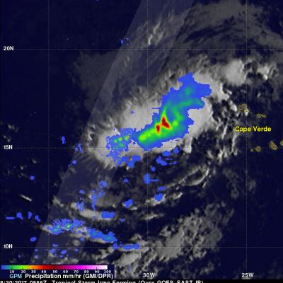
The National Hurricane Center (NHC) upgraded a low pressure area in the far eastern Atlantic Ocean to tropical storm Irma on August 30, 2017 at 11:00 AM AST (1500 UTC). Tropical cyclones that form in that part of the Atlantic Ocean are often the largest and most powerful hurricanes of the season. Hurricanes Ivan (2004), Isabel (2003), Hugo (1989) and Allen (1980) are examples of past powerful hurricanes that formed near the Cape Verde islands. The GPM core observatory satellite flew above forming tropical storm Irma on August 30, 2017 at 1:56 AM EDT (0556 UTC). This new tropical cyclone was