Extreme Weather

Extreme weather news and updates.

New Zealand's Extreme Rainfall Examined With IMERG

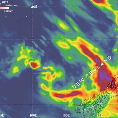
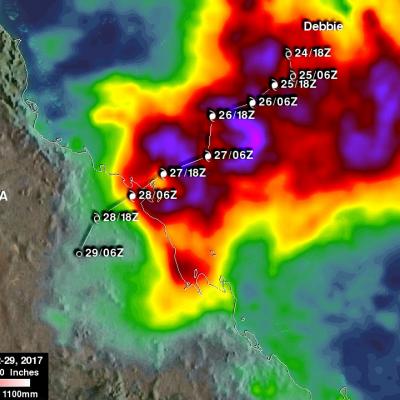
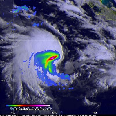
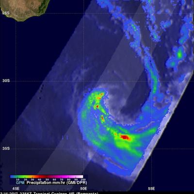
Two extra-tropical cyclones recently dropped very heavy rain over New Zealand. Tropical cyclone Debbie dumped extreme amounts of rain over the northeastern coast of Australia when it hit the Queensland coast on March 28, 2017. After drenching northeastern Australia Extra-tropical Cyclone Debbie transported a river of water over New Zealand last week. Debbie's remnants dropped heavy rainfall that caused widespread flooding near the Bay of Plenty on New Zealand's northeastern coast. Thousands of residents needed to be evacuated with extra-tropical cyclone Debbie. This week extra-tropical cyclone

Texas' Heavy Rain Measured By IMERG

Over the past few days a slow moving frontal system moving through the Southwest produced heavy rain resulting in flooding and mudslides over central Texas. One person was reported swept away by flood water near Fort Hood Texas. NASA's Integrated Multi-satellitE Retrievals for GPM (IMERG) data were used to provide an estimate of rainfall accumulation over Texas. From April 10-12, 2017 IMERG estimates indicate that over 8 inches (203 mm) of rain fell in the area from central Texas through northern Louisiana.
GPM Catches Nor'easter over New England
At the time of the Global Precipitation Measurement (GPM) Core Observatory overpass (April 1, 2017, 0550 UTC), the storm's center of low pressure was south of Long Island. At the mid-levels of the atmosphere, the circulation was centered over northeast Pennsylvania. This led to a classic overrunning, warm conveyor setup, which happened when the counterclockwise low level flow drew in cold air out of the north/northeast (hence "Nor'easter") from Canada. Higher up, warm and moist air from further south was lifted over this cold air and resulted in precipitation in the form of snow at the surface...

GPM Observes Tropical Cyclone Forming North of Australia

The GPM Core Observatory satellite flew directly above a forming tropical cyclone in the Timor Sea northeast of Darwin, Australia on April 10, 2017 at 1146 UTC. Data collected by GPM's Microwave Imager (GMI) and Dual-Frequency Precipitation Radar (DPR) instruments showed that convective storms within the tropical low contained very heavy rainfall. GPM's DPR (Ku Band) data revealed that a line of intense storms west of the Bathurst and Melville islands was dropping rain at a rate of over 161 mm (6.3 inches) per hour. A 3-D examination of the forming tropical cyclone's cloud tops showed that

Deadly Flooding Rains Near Mocoa, Colombia Measured By IMERG

Late Friday night and Saturday morning flash flooding and mudslides killed over 250 people in Mocoa, Colombia. Extremely intense storms added heavy rain to water logged terrain around Mocoa. Water from this heavy rainfall converged into a river that runs close to Mocoa causing it to overflow it's banks with deadly results. Integrated Multi-satellitE Retrievals (IMERG) data were used to estimate the amount of rain that fell near Mocoa, Colombia during the seven day period from March 26 to April 2, 2017. IMERG indicates that area rainfall totals during the week were frequently greater than 80 mm
GPM Measures Tropical Cyclone Debbie
Tropical cyclone Debbie formed in the Coral Sea northeast of Australia om March 24, 2017. Debbie intensified and had hurricane force wind speeds within a day of formation. While headed toward northeastern Australia Debbie reached it's maximum sustained wind speeds estimated at over 100 kts (115 mph) on March 27, 2017 (UTC). Tropical cyclone Debbie came ashore on March 28th and brought destructive winds and extremely heavy rain to northeastern Australia. It was reported that heavy rainfall caused flash flooding that cut off a coastal town and covered several roads in Queensland. The GPM...

Tropical Cyclone Caleb's Rainfall Revealed By GPM

Tropical cyclone Caleb formed today in the South Indian Ocean southwest of the Indonesian Island of Sumatra. The GPM core observatory satellite had a fairly good view of the the newly formed tropical cyclone when it flew over on March 23, 2017 at 0756 UTC. The satellite's Microwave Imager (GMI) revealed the locations of rainfall within the tropical cyclone. Rainfall measurements derived from the GMI showed that convective storms's were dropping rain at a rate of almost 84 mm (3.3 inches) per hour on Caleb's eastern side. The Joint Typhoon Warning Center (JTWC) predicts that tropical cyclone

Peru's Deadly Rainfall Examined With NASA's GPM Data

This year unusually heavy rainfall has caused extensive flooding and loss of life in Peru. Extreme flooding and frequent landslides that occurred this month have forced many from their homes. An El Niño like condition with warm ocean waters developed near Peru's coast. This extremely warm water off Peru's western coast has been blamed for promoting the development of these storms. Equatorial sea surface temperatures (SSTs) are about average elsewhere in the central and east central Pacific. This image shows the locations of storms that were dropping heavy rainfall over northwestern Peru when

GPM Sees Powerful Convective Storms In The Timor Sea

The GPM core observatory satellite passed above some energetic storms in the Timor Sea north of Australia on March 20, 2017 at 0726 UTC. These powerful storms were being invigorated by very warm sea surface temperatures and low vertical wind shear aloft. Balmy water in the Timor Sea was reaching temperatures of 30 to 32 degrees Celcius (86 to 89.6 Fahrenheit). Data collected by GPM's Microwave Imager (GMI) and Dual-Frequency Precipitation Radar (DPR) instruments showed that these storms contained some very heavy downpours. GPM's DPR found rain falling at a rate of over 238 mm (9.4 inches) per

Tropical Cyclone's Remnants Examined By GPM

The GPM core observatory satellite flew above the remnants of tropical cyclone 11S on March 14, 2017 at 2356 UTC. The remnants were located south-southeast of Madagasgar and were rapidly transforming into an extra-tropical low. GPM showed the locations of intense rainfall still being produced by the low. GPM's Dual-Frequency Precipitation Radar (DPR) data showed that rain was falling at a rate of over 205 mm (8 inches) in a few storms. GPM's radar (DPR Ku Band) found that some storm tops in the remnants were reaching heights above 13 km (8 miles). GPM satellite radar (DPR Ku Band) data were