GPM Examines Tropical Cyclone Uriah
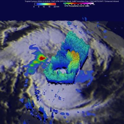
Over the past view days the GPM core observatory satellite has had good looks at tropical cyclone URIAH in the South Indian Ocean west of Australia. On February 15, 2016 at 1706 UTC GPM flew directly over the center of the tropical cyclone and measured rainfall in a well defined circulation. GPM's Dual-frequency Precipitation Radar (DPR) instrument discovered that rain was falling at a rate of over 127 mm (5 inches) per hour in a band of intense storms south of the cyclone's center. When GPM's Radar sliced through tropical storm URIAH on February 15, 2016 it also found that the intense