Extreme Weather

Extreme weather news and updates.

GPM Hurricane Douglas 7-25-20
Hurricane Douglas continued to approach the Hawaiian islands during this GPM overpass early in the morning (02:11 UTC) of July 25, 2020. Douglas had previously strengthened to a Category 4 hurricane the day before, but had substantially weakened over cooler waters throughout the day. Regardless, the GMI and DPR instruments recorded rain rates near 50 millimeters/hour (~2 inches/hour) near Douglas` center. The Central Pacific Hurricane Center advised residents of Hawaii to expect hurricane-strength winds and rainfall starting Saturday evening and lasting through Monday. View fullscreen in STORM
IMERG rainfall totals from Japan, July 3 - 9 2020
From July 3-9, 2020, NASA’s IMERG algorithm continued to observe the heavy precipitation that fell as part of the seasonal Meiyu-Baiu rains (“plum rains”) in east Asia. Weekly totals reached their regional maxima over the island of Kyushu in southern Japan. About half of the island of Kyushu received over 45 cm (~18 inches) of rain. The majority of Honshu, Japan’s main island, as well as Shikoku to its south, were also impacted by the rains, receiving from 10-25 cm, depending on the location. Additionally, large areas of eastern China were also covered by the plum rains during this weekly
IMERG rainfall totals from Japan, June 29 - July 5, 2020
This animation shows NASA IMERG rain rates (blue shading) and accumulations (green shading) near Kyushu island, in the southwest of Japan from June 29 - July 5, 2020. Devastating floods and landslides swept through parts of Kyushu on July 4, 2020, resulting in over 40 deaths and orders for hundreds of thousands of people to evacuate their homes according to media reports. Download video (right-click -> Save As) The rains that triggered the flooding occurred in the context of the Meiyu-Baiu rainy season, which arrives in east Asia every year from June to mid-July. “Meiyu” and “Baiu” are the

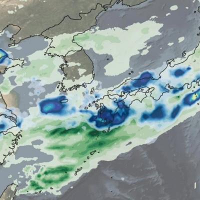
GPM Views Southeast Snowstorm

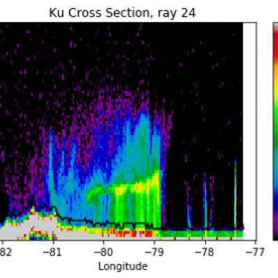
On February 20th and 21st, 2020, a winter storm brought the seasons largest snowfall to much of North Carolina and southern Virginia. The highest snow totals of 3-5 inches (7-12 cm) were located in northeast NC and southeast VA. GPM's radar captured captured the reflectivities shown in this cross-section as it flew over the snow storm on February 20th, with snow and frozen precipitation shown in blue and purple and rain shown in green and yellow. The melting layer marks the transition from snow to rain and slopes upward 2-3 km from central NC to the coast. These raw reflectivity measurements

GPM Measures Heavy Rainfall from "The Dragon" Cyclonic Storm System in the Middle East

GPM observed the early stages of a strong cyclonic system that developed over northern Africa just off the southern Mediterranean coast on March 11, 2020. The GMI measured heavy rain rates over some parts of Egypt, including the region around Cairo. View fullscreen By March 12, 2020, the cyclonic system that developed over northern Africa had intensified and was nicknamed 'The Dragon' on social media and news outlets, as it caused severe flooding in northern Egypt. Both the GMI and the DPR measured heavy rain rates across two of the storm's bands in this GPM overflight. View fullscreen On

Tropical Storm Imelda Brings Flooding Rain To Texas

By Friday morning, September 20, the rainfall from the remnant of Tropical Storm Imelda had increased to over 24 inches in some areas near the Gulf of Mexico coast between Beaumont and Houston, Texas. This rainfall was in excess of what had been forecasted a few days earlier and was due to Imelda's forward motion ceasing for approximately 24 hours between Wednesday and Thursday afternoon. The image shows, with large "L" symbols, the location estimated by the National Hurricane Center for Imelda's low-pressure center of rotation at various times over the past three days. This near-realtime rain

GPM IMERG Measures Hurricane Dorian's Rainfall from the Caribbean to Canada

Hurricane Dorian (2019) brought heavy rain to the Caribbean, along the US East Coast, and up to Canada. NASA satellite-based precipitation estimates tracked the storm throughout its lifetime, as shown by the sequence of images below. September 3, 2019: Hurricane Dorian over Grand Bahama and Abaco Islands In the early hours of Tuesday, September 3, Hurricane Dorian had been stationary over the island of Grand Bahama for 18 hours, most of the time as a category 5 hurricane. Storm-total rain accumulation over parts of Grand Bahama and Abaco islands have exceeded 24 inches according to NASA

Heavy Rain Leads to Flooding in Brazil

UPDATE 2/12/2020: An extended IMERG analysis of rainfall in Brazil shows even more extreme rainfall occurring in the first weeks of February, with large regions experiencing rainfall totals over 18 inches since the start of 2020. According to local authorities, the region has already received 98% of the rainfall that is typically expected to fall during all of February. UPDATE 1/30/2020: During January 2020, parts of the Brazilian states of Minas Gerais and Espirito Santo experienced above average rainfall, causing deadly floods in the region. Part of the month's heavy rainfall came from a

GPM IMERG Observes Rainfall from Tornado-spawning Storms in the Southern U.S.

Download video (right-click -> Save As). Credit: Jason West (KBR / NASA GSFC) From Sunday, April 12th, 2020 into Monday the 13th, a series of powerful thunderstorms developed across the southern U.S., bringing heavy rainfall and spawning several destructive tornadoes. This animation shows rainfall estimates for the region for April 11th - 13th derived from NASA's Integrated Multi-satellite Retrievals for GPM (IMERG) data product, along with NOAA tornado reports (red triangles).