Extreme Weather

Extreme weather news and updates.

Cristobal Drenches Central America

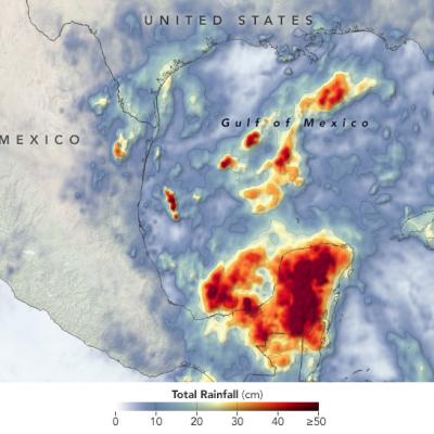
The 2020 Atlantic hurricane season is off to a busy start. By the first week of June, Tropical Storm Arthur had already brushed North Carolina, Tropical Storm Bertha had drenched South Carolina, and the third named storm of the year— Cristobal—was dropping torrential rain on the Yucatán Peninsula. The storm first developed in the Pacific in late May as Tropical Storm Amanda, spinning off the southern end of a seasonal low-pressure pattern called the Central American Gyre. After making landfall in Guatemala and causing deadly floods in El Salvador, Amanda weakened and became less organized as

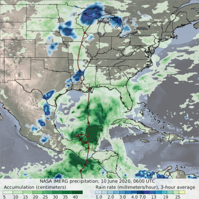
GPM IMERG Measures Rainfall from Tropical Storm Cristobal

This animation shows NASA IMERG rain rates (blue shading) and accumulations (green shading) alongside the NOAA low-pressure center track (red line) of Tropical Storm Amanda/Cristobal. The origin of this storm was in the eastern Pacific Ocean in late May 2020, where it was named Tropical Storm Amanda as it approached the southern Mexican and Central American coast. Amanda made landfall in Guatemala on May 31, where it began to deliver the first of a series of heavy rain pulses that led to flooding in the region. After temporarily stalling over land, the system reformed over the Bay of Campeche on June 1 as Tropical Storm Cristobal and made its second landfall on June 3 in Mexico. The storm continued to deliver several pulses of heavy rainfall to southern Mexico, Guatemala, and El Salvador. Some areas of the region accumulated over 60 cm (~2 feet) of rainfall throughout Cristobal's passage. The storm then crossed the Gulf of Mexico and made landfall in Louisiana on June 7 and progressed northward as a tropical depression before being classified as an extratropical low pressure system over Wisconsin on June 10. Large swaths of the U.S. Gulf Coast and Midwest as far north as Wisconsin saw accumulations in excess of 10 cm (~4 inches), and some areas along the coasts of Florida, Alabama, and Mississippi received over 20 cm (~8 inches), during Cristobal’s passage.
Cyclone Amphan IMERG Rainfall Totals
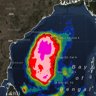
On May 16, 2020, NASA / JAXA's GPM Core Observatory satellite observed the early stages of Tropical Cyclone Amphan as it tracked north over the Bay of Bengal. The below GPM overpass shows precipitation within Cyclone Amphan a day before it explosively intensified into a category 4-equivalent cyclone. Even at this early stage, Amphan produced heavy rain rates near its center and to its west and southwest. View fullscreen in STORM Event Viewer NASA monitored the heavy rain associated with Tropical Cyclone Amphan as it made landfall at 0900 UTC (2:30 PM local time) on May 20, 2020. Landfall...
Typhoon Vongfong IMERG Rainfall Totals
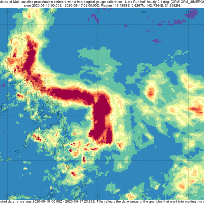
The first typhoon of the season, Vongfong, struck the central Philippines this past week (where it is known as Ambo) as a strong category 2 storm, bringing strong winds and locally heavy rainfall. Vongfong formed into a tropical depression in the southern Philippine Sea west of Palau on Sunday May 10th from a disturbance that had been slowly making its way westward over the past several days. After becoming a depression, the system moved northward toward the central Philippine Sea and slowly began to intensify. Then, on the 12th when it reached tropical storm intensity, Vongfong’s northward...
GPM Overpass of Cyclone Harold from April 6th, 2020
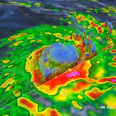
Video credit: Greg Shirah, Kel Elkins, Alex Kekesi (NASA Goddard Scientific Visualization Studio). For more information or to download this public domain video, go to: https://svs.gsfc.nasa.gov/4812#29226 A Category 4 cyclone, the most powerful yet of 2020, made landfall on the South Pacific nation of Vanuatu on Monday, not long before this GPM overpass from April 6th, 2020 at 1:41 UTC. Tropical Cyclone Harold developed from a low pressure system that was observed to the east of Papua New Guinea last week, and has tracked to the southeast, where it has already caused flooding and loss of life...
Extratropical Storm Dennis, February 15, 2020
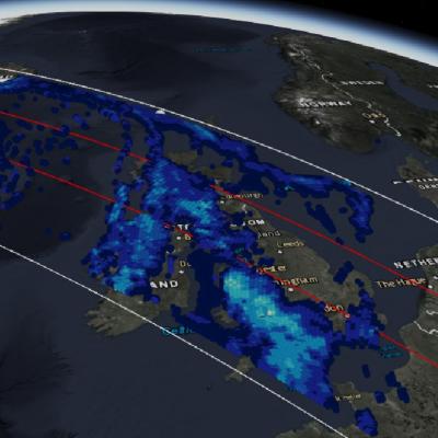
Storm Dennis is an extratropical cyclone that developed over the continental United States before undergoing explosive intensification as it crossed into the North Atlantic. On February 15 shortly after this GPM overpass, Dennis reached its minimum central pressure of 920 mb, which is reported to be the second-lowest on record for a North Atlantic winter storm. The eye can be seen south of Iceland, while rain bands to the south caused severe flooding across the British Isles. Text & Visualization by Jason West (NASA / KBR)
Typhoon Kammuri Hits the Central Phiippines
While the Atlantic hurricane season officially ended on November 30th, Typhoon Kammuri (known as Tisoy in the Philippines), which recently struck the central Philippines as a powerful Category 4 typhoon, is a reminder that the Pacific typhoon season is not yet over. In fact, while typhoon season does peak from around June through November, similar to the Atlantic, typhoons can occur throughout the year in the Pacific. Kammuri first formed into a tropical depression from an area of low pressure on the 25th of November north of Micronesia in the west central Pacific about 500 miles southeast of Guam.
Typhoon Hagibis Brings Heavy Rains to Japan
Typhoon Hagibis, a once powerful super typhoon, struck the main Japanese island of Honshu over the weekend, bringing very heavy rains and widespread flooding. Hagibis formed into a tropical storm on the 5th of October from a tropical depression that originated from a westward moving tropical wave north of the Marshall Islands. At first, Hagibis strengthened steadily becoming a typhoon about 24 hours after becoming a tropical storm. But, then on the 7th, Hagibis underwent a remarkable rapid intensification cycle and quickly intensified into a super typhoon with sustained winds estimated at 160 mph by the Joint Typhoon Warning Center (JTWC) less than 24 hours after becoming a minimal typhoon.
GPM observes Hurricane Dorian lashing Florida
Download in high resolution from the NASA Goddard Scientific Visualization Studio GPM captured Dorian at 10:41 UTC (6:41 am EDT) on the 4th of September when the storm was moving north-northwest parallel to the coast of Florida about 90 miles due east of Daytona Beach. Three days earlier, Dorian had struck the northern Bahamas as one of the most powerful Category 5 hurricanes on record in the Atlantic with sustained winds of 185 mph. Weakening steering currents allowed the powerful storm to ravage the northern Bahamas for 2 full days. During this time, Dorian began to weaken due to its...
Hurricane Dorian Brings Heavy Rain to Bahamas
In addition to the powerful winds that have raked the northern Bahamas over the past few days, Hurricane Dorian’s slow motion has brought very heavy rainfall to the islands as well. Dorian first formed into a tropical depression on the 24th of August about 800 miles east southeast of Barbados in the Lesser Antilles from an area of low pressure; the depression was quickly upgraded to a minimal tropical storm and named Dorian by the National Hurricane Center (NHC) later in the day. As Dorian made its way westward under the influence of a high pressure ridge to the north, it was held in check...