Images and caption by Hal Pierce (SSAI/NASA GSFC)

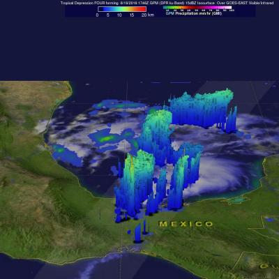
Danielle Hits Mexico And Weakens

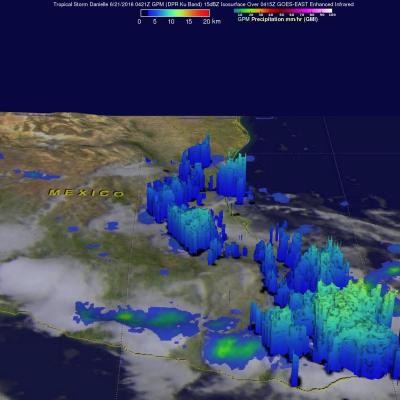
Tropical Storm Danielle started weakening after making landfall north of Tuxpan, Mexico on Monday evening just before June 21, 2016 at 0000 UTC (June 20, 2016 7:00 PM CDT). As Danielle weakened the low level circulation quickly became disorganized. The GPM core observatory satellite passed above rapidly weakening Danielle on June 21, 2016 at 0421Z (June 20, 2016 11:21 PM CDT). The approximate center of Danielle's circulation at the time of this GPM pass is shown with a red tropical storm symbol. A rainfall analysis from GPM's Microwave Imager (GMI) and Dual-Frequency Precipitation Radar (DPR)

GPM Sees Tropical Storm Danielle Forming

A tropical depression (TD4) in the southwestern Gulf of Mexico was designated tropical storm Danielle by the National Hurricane Center (NHC) this morning at 1500 UTC (1000 AM CDT). Danielle is the earliest fourth-named tropical storm to form in the Atlantic Basin. Danielle's life as a tropical storm is predicted to be short because it is moving almost due west and is predicted to move over the east coast of Mexico later today or tonight. Heavy rainfall is expected to cause flash floods and mudslides over eastern Mexico over the next few days. The GPM core observatory satellite flew above the

IMERG Sees Onset Of Possibly Wetter India Monsoon

On June 8 the nodal weather agency of India (IMD) declared the arrival of the 2016 Southwest Monsoon over the Indian state of Kerala. This season is expected to be rainier than recent years. The El Nino conditions which have been blamed for recent disappointing monsoons has weakened to ENSO-neutral conditions. ENSO-neutral conditions are expected to transition to La Nina in the northern hemisphere by the fall and winter of 2016-17. La Nina conditions normally result in beneficial wetter and cooler monsoons in India. An animation of weekly rainfall totals was derived from NASA's Integrated

Tropical Storm Colin's Heavy Rainfall Examined From Space

Earlier this week the Governor of Florida declared a state of emergency as tropical storm Colin moved over the state. In just a few days heavy rainfall from the tropical storm spread from Florida's Gulf Coast through Georgia to the North Carolina coastline. Street flooding was common in Florida. Severe flooding was not reported but over 250 mm (10 inches) of rain was reported in some areas. Two tornadoes and a water spout reported in Florida on Monday June 6, 2016 were an example of the unstable weather accompanying the tropical storm. Data from NASA's Integrated Multi-satellitE Retrievals for

GPM Sees Tropical Depression Bonnie In The Atlantic

The GPM core Observatory had another good look at revived tropical Depression Bonnie on June 3, 2016 at 0716 UTC (3:16 AM EDT). Rainfall calculated from data received by GPM's Microwave Imager (GMI) and and Dual-Frequency Precipitation Radar (DPR) instruments are shown in the first image. Those instruments found that Bonnie was dropping rain at a rate of over 65 mm (2.6 inches) per hour in storms south of the depression's center of circulation. GPM's Radar (DPR Ku Band) again measured the 3-D structure of rainfall within Bonnie and found that some storms were reaching heights of over 13 km (8

Rainfall Causes Texas and Oklahoma Flooding

Continuing heavy rain has resulted in dangerous flooding conditions from Oklahoma through eastern Texas. The Brazos, Trinity and Colorado Rivers in Southeastern Texas are at or above flood stage. Flooding resulted in the deaths of at least 6 people in Texas during the past week. Governor Greg Abbott declared a state of disaster in 31 Texas counties. Over 20 inches of rainfall were reported in some areas since May 30, 2016. Parts of Georgia and the Carolinas were flooded by very slow moving tropical depression Bonnie. This estimate of rainfall totals from May 27, 2016 to June 2, 2016 was made

GPM Sees Bonnie as a Tropical Depression Again

Tropical storm Bonnie weakened to a tropical depression on May 29, 2016. The circulation was labeled as "Post-Tropical" and has been moving very slowly to the northeast near the Carolinas coastline. Bonnie developed organized convection near the center and the system has again been labeled a tropical depression. The GPM core observatory satellite saw Tropical Depression Bonnie on June 1, 2016 at 2226 UTC (6:26 PM EDT). GPM's Microwave Imager (GMI) and and Dual-Frequency Precipitation Radar (DPR) instruments measured precipitation in a few powerful convective thunderstorms falling at a rate of

GPM Examines Tropical Depression Bonnie In The Carolinas

The GPM core observatory satellite had an excellent view of Tropical Depression Bonnie as it flew over the southeastern United States on May 29, 2016 at 2326 UTC (7:26 PM EDT). Rainfall was analyzed using data collected by GPM's Microwave Imager (GMI) and and Dual-Frequency Precipitation Radar (DPR) instruments. GPM's radar (DPR) showed rain falling at a rate of over 25.4 mm (1 inch) per hour in South Carolina. GPM's Radar (DPR Ku Band) was able to see through cloud cover in the tropical depression and show the vertical shape of rain within storms. The heights of storm tops were derived from

Deadly Flooding Rainfall Over Texas And Tropical Storm Bonnie Measured From Space

Heavy rainfall caused deadly flooding in southeastern Texas. At least 4 people have been killed and continuing rainfall is expected to cause historic flooding in that area. Meanwhile, dissipating Tropical storm Bonnie is soaking the South Carolina coast, southeastern North Carolina and eastern Georgia on this Memorial Day weekend. Some flooding is expected as dissipating tropical storm Bonnie's rainfall moves northeastward along the coast. This analysis of liquid precipitation from space was accomplished by using merged satellite rainfall data from the TRMM Multi-satellite Precipitation

GPM Sees Potential Atlantic Tropical Cyclone

An area of low pressure located in the Atlantic Ocean between Bermuda and the Bahamas is being monitored today for possible development into a tropical or subtropical cyclone. Shower activity has increased in the area. The National Hurricane Center (NHC) has advised interests along the southeastern coast of the United States to monitor the progress of this low. The GPM core observatory satellite flew over this showery area on May 26, 2016 at 0932 UTC (5:30 AM EDT). GPM's Microwave Imager (GMI) and and Dual-Frequency Precipitation Radar (DPR) instruments measured precipitation around the low