Images and caption by Hal Pierce (SSAI/NASA GSFC)

IMERG Measures Flooding Rainfall In Pakistan

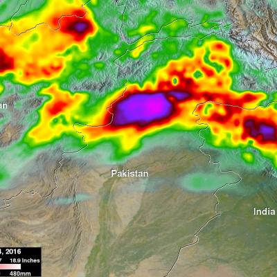
Over the past few days heavy rainfall caused flooding that killed more than 50 people in northwestern Pakistan. Heavy pre-monsoon rainfall moved through the area resulting in extensive damage in the Swat Valley northwest of Islamabad the capital of Pakistan. Data from NASA's Integrated Multi-satellitE Retrievals for GPM (IMERG) were used to estimate the rainfall that occurred from April 1-4, 2016. Up to 308 mm (12.1 inches) estimated by IMERG to have fallen during this period.

GPM Satellite Examines Tornadic Thunderstorms

Over the past few days tornado spawning thunderstorms have occurred in the states of Texas, Oklahoma, Arkansas, Louisiana, Indiana, Mississippi, Alabama and Georgia. Large hail, damaging winds, and flash flooding associated with a frontal system moving across the United States have compounded the damage from these storms. Hail the size of a half-dollar was reported near Jackson, Louisiana on Thursday evening. The GPM core observatory satellite flew over this stormy area on April 1, 2016 at 0241 UTC (March 31, 2016 at 10:41 PM EDT). Tornadoes were reported in Mississippi, Alabama and Georgia

Tropical Cyclone Emeraude Viewed By GPM

As expected, tropical cyclone Emeraude formed on March 15, 2016 from a tropical low (99s) in the South Indian Ocean. The GPM core observatory satellite flew above intensifying Emeraude on March 16, 2016 at 2121Z after the tropical cyclone's maximum sustained winds had increased to greater than 90 kts (103.5 mph). Rainfall just northwest of Emeraude's eye was measured by GPM's Dual-Frequency Precipitation Radar (DPR) instrument falling at a rate of over 209 mm (8.2 inches) per hour. The powerful thunderstorms producing this extreme rainfall were measured by GPM's radar (DPR) reaching an

GPM Spots Potential South Indian Ocean Tropical Cyclone

The GPM Core Observatory satellite saw possible tropical cyclone formation in the South Indian ocean on March 15, 2016 at 0900 UTC. A rainfall analysis using data collected by GPM's Microwave Imager (GMI) and Dual-Frequency Precipitation Radar (DPR) shows rain bands wrapping around a tropical low. GPM's DPR measured rain falling at the extreme rate of over 220 mm (8.7 inches) per hour in powerful storms south of the low's center of circulation. GPM's radar (DPR Ku Band) data were able to show the 3-D structure of precipitation within the tropical low. Storm tops heights were measured by GPM

Torrential Rain Over South Measured From Space

Extremely heavy rain fell over the southern United States during the past week. A slow moving area of low pressure pumped moisture from the Gulf Of Mexico causing torrential rain that resulted in wide spread flooding in states from Texas to Tennessee. Over 24 inches of rain was reported in Monroe, Louisiana. Over 4,958 homes in Louisiana were reportedly damaged by the flooding. Strong winds accompanying intense thunderstorms also toppled trees in Mississippi and Louisiana. A simulated 3-D animation of NASA merged satellite rainfall analysis (TMPA) using data collected from March 7-14, 2016

GPM Views Severe Weather And Heavy Rain in the U.S.

The GPM satellite flew above storms in the southwestern United States this morning (March 9, 2016) at 1011 UTC (5:11 CST). Severe weather has been moving slowly through this area for the past couple days. Two tornadoes developed in north central Texas yesterday morning (March 8, 2016). This morning rain was measured by GPM's Dual-Frequency Precipitation Radar (DPR) instrument falling at the extreme rate of over 148 mm (5.8 inches) in one powerful storm over eastern Texas. GPM's radar (DPR Ku Band) found that a few thunderstorm tops in this area were reaching altitudes above 13.7 km (8.5 miles)

IMERG Analyzes El Niño Fueled California Storms

After a break in February, El Nino fueled storms have started pounding California as they move in from the Pacific Ocean. Northern California has been especially hard hit with heavy rainfall and strong winds being reported. Heavy rainfall north of Sacramento caused flooding that killed a woman in Olivehurst, California. Rain and snowfall in the Sierra Nevada mountains may help to alleviate the long lasting California drought. An analysis of total precipitation from February 29 to March 7, 1016 was accomplished using data collected by NASA's Multi-satellitE Retrievals for GPM (IMERG). This

Peru Flooding Rainfall Measured By IMERG

Heavy rainfall recently caused flooding, landslides and power cuts in some areas of Peru. Thousands were made homeless and at least two people were reportedly killed. Extremely heavy rainfall was reported in northern Peru on February 26 and February 27, 2016. In some areas the Peruvian army was sent to help those affected by flooding. The strong El Niño was partially blamed for the abnormally high rainfall in this area. NASA's Multi-satellitE Retrievals for GPM (IMERG) data collected from February 23-29, 2016 were used to estimate rainfall totals over this area of South America. The highest

GPM See Potential Tropical Cyclone

The GPM core observatory satellite flew over an area of disturbed weather in the South Pacific near Bora Bora early today where a tropical cyclone may be forming. On February 29, 2016 at 0456 UTC GPM's Microwave Imager (GMI) saw rain falling at an estimated rate of almost 48 mm (1.9 inches) per hour in an area of deep convection south of a tropical low. GPM's Dual-frequency Precipitation Radar (DPR) instrument measured cloud top heights at an altitude of over 10.5 km (6.5 miles) in rain showers between Bora Bora and Tahiti.

Tropical Cyclone Winston Hits Fiji

The GPM core observatory satellite flew directly above tropical cyclone Winston on February 20, 2016 at 0941 UTC. Tropical cyclone Winston had sustained winds estimated at 155 kts (178 mph) at that time. A rainfall analysis derived from data collected by GPM's Microwave Imager (GMI) and Dual-frequency Precipitation Radar (DPR) instruments found that in addition to powerful winds Winston was dropping rain at a rate of over 169 mm (6.7 inches) per hour in the western side of the eye. Tropical cyclone WINSTON is the most powerful storm to hit Fiji. At least one fatality has already occurred. The