Images and caption by Hal Pierce (SSAI/NASA GSFC)

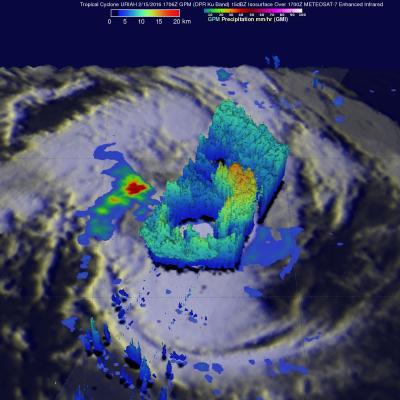
GPM Again Examines Powerful Tropical Cyclone Uriah

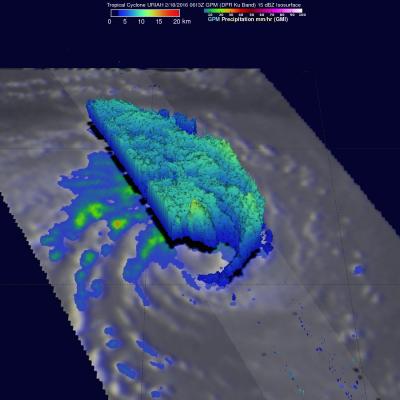
Both yesterday and today the GPM core observatory satellite had excellent views of tropical cyclone Uriah in the South Indian Ocean. Uriah was intensifying with winds of about 115 kts (132 mph) on February 17, 2016 at 1651 UTC when the GPM satellite passed above. A rainfall analysis derived from GPM's Microwave Imager (GMI) and Dual-frequency Precipitation Radar (DPR) data collected with that pass revealed that Uriah had a well defined circular eye. Rain was measured by DPR falling at a rate of over 179 mm (7 inches) per hour on the southern side of Uriah's eye wall. GPM passed over again on

GPM Examines Tropical Cyclone Uriah

Over the past view days the GPM core observatory satellite has had good looks at tropical cyclone URIAH in the South Indian Ocean west of Australia. On February 15, 2016 at 1706 UTC GPM flew directly over the center of the tropical cyclone and measured rainfall in a well defined circulation. GPM's Dual-frequency Precipitation Radar (DPR) instrument discovered that rain was falling at a rate of over 127 mm (5 inches) per hour in a band of intense storms south of the cyclone's center. When GPM's Radar sliced through tropical storm URIAH on February 15, 2016 it also found that the intense

Intensifying South Pacific Tropical Cyclone Winston Viewed By GPM

Tropical cyclone activity has recently increased in the South Pacific Ocean. Four tropical cyclones have formed in this area in 2016. The GPM core observatory satellite had an excellent view of tropical cyclone Winston on February 11, 2016 at 1253 UTC. Winston was located east of Vanuatu with tropical storm force winds of about 55 kts when GPM passed over head. Winston's rainfall was measured by GPM's Microwave Imager (GMI) and Dual-frequency Precipitation Radar (DPR) instruments. GPM's radar data revealed that Winston was dropping rain at a rate of over 60 mm (2.4 inches) per hour on the

GPM Views Tropical Cyclone Forming Near Madagascar

The GPM core observatory satellite flew over a forming tropical cyclone in the South Indian Ocean between Madagascar and Reunion on February 8, 2016 at 2137 UTC. Low vertical wind shear will assist in the evolution of the tropical low as it moves slowly toward the southwest. Rainfall derived from GPM's Microwave Imager (GMI) and Dual-frequency Precipitation Radar (DPR) data revealed that powerful convective storms near Madagascar's eastern coast were found to be dropping rain at a rate of over 94 mm (3.7 inches) per hour. 3-D measurements were made of convective storm tops with GPM's radar

Intensifying Atlantic Storm Examined By GPM

On February 8, 2016 at 0800 UTC (3 AM EST) the GPM core observatory satellite flew above an intensifying storm in the Atlantic Ocean off the United State's East Coast. This storm is forecast by the National Weather Service (NWS) to bring strong winds, heavy rainfall, and coastal flooding to the Carolina's. Although the center of the storm is well off the coast, bands of precipitation from the storm are also expected to bring heavy snow to eastern New England. A rainfall analysis derived from data collected by GPM's Microwave Imager (GMI) and Dual-frequency Precipitation Radar (DPR) instruments

GPM Examines Violent Thunderstorms in U.S.

Severe weather moved through the southern U.S. on February 2 and 3, and NASA's Global Precipitation Measurement or GPM core satellite examined the violent thunderstorms. On February 3, 2016 at 1851 UTC (1:51 p.m. EST) the GPM core observatory satellite flew over a line of storms extending from the Gulf coast of Florida through New York state. Tornadoes were spotted in Georgia and South Carolina within this area of violent weather. GPM's Microwave Imager (GMI) and Dual-frequency Precipitation Radar (DPR) instruments measured the precipitation within the area. As the satellite passed above, GPM

Extreme Precipitation Measured From Space

For over a week the weather over the continental United State's has been punctuated by extreme events. Automobiles were thrown around on January 27, 2016 by tornadoes that hit southern Florida. On January 31 a winter storm with heavy rain, strong winds and isolated thunderstorms hit southern California killing at least one person. There were numerous reports of hail with these storms ranging from pea sized to up to an inch in diameter. Powerful winds with these storms also brought down trees and power lines. A blizzard that followed the Democratic and Republican caucuses in Iowa dropped over

Intensifying Tropical Low Threatens Western Australia

So far this year, no tropical cyclones have formed near Australia. A tropical low is now getting better organized in the Indian Ocean off Australia's northwestern coast. The GPM core observatory flew over this area of disturbed weather on January 27, 2016 at 0946 UTC. GPM's Dual-frequency Precipitation Radar (DPR) instrument measured rain falling at a rate of 96.7 mm (3.8 inches) per hour in towering convective storms within spiraling bands around the tropical low. GPM's Radar (DPR Ku band) made 3-D measurements of convective storm top heights. Some storm tops were found to reach altitudes of

GPM Flies Over Dissipating Tropical Cyclone Corentin

Tropical cyclone Corentin was the first named tropical cyclone of 2016 in the South Indian Ocean. Corentin caused little danger because it's genesis, maturation and dissipation have all occurred over the South Indian Ocean about equidistant from the distant shores of Madagascar and Australia. The GPM core observatory satellite flew over Tropical Cyclone Corentin on January 25, 2016 at 1306 UTC. High vertical wind shear was starting to take it's toll on the increasingly disorganized tropical cyclone. Rainfall collected by GPM Microwave Imager (GMI) and Dual-frequency Precipitation Radar (DPR)

Developing Tropical Cyclone Viewed By GPM

The GPM core observatory satellite saw a tropical cyclone developing in the South Indian Ocean east of Madagascar on January 21, 2016 at 0146 UTC. GPM's Microwave Imager (GMI) and Dual-frequency Precipitation Radar (DPR) measured precipitation in the potential tropical cyclone. The most intense showers were shown by the GMI instrument to be dropping rain at a rate of over 71 mm (2.8 inches) per hour in strong storms to the northeast of the tropical low's center of circulation. GPM's radar (DPR) viewed a swath of data to the west of the developing tropical cyclone center where rain was measured