Missions

20 Years of IMERG - Resources
NASA Announces Long-term IMERG Satellite Record: A Near-Global 19-year Perspective on Rain and Snow NASA has just released its newest estimate of rain and snow covering the past 19 years. It's code name: Version 6 IMERG. NASA's IMERG -- the Integrated Multi-satellitE Retrievals for GPM -- combines information from whatever constellation of satellites are operating in Earth orbit at a given time, to estimate precipitation over the majority of the Earth's surface. This algorithm is particularly valuable over the majority of the Earth's surface that lacks precipitation-measuring instruments on...
Two Decades of Precipitation Measurement
NASA’s Precipitation Measurement Missions (PMM) have collected rain and snowfall from space for nearly 20 years, and for the first time in 2019, scientists can access PMM’s entire record as one data set. PMM includes two missions – the Tropical Rainfall Measuring Mission (TRMM), which orbited Earth from 1997 to 2015, and its successor, the joint NASA-JAXA Global Precipitation Measurement mission (GPM), which has been collecting data since 2014. This year, however, the GPM project upgraded its data algorithms to calibrate and incorporate TRMM data into its release, giving researchers, modelers...
GPM flying over Earth with a data swath visualized.
Due to NASA network policies the NASA Precipitation Processing System (PPS) will be transitioning from FTP to FTPS for access to download GPM and TRMM data. As a result of this change, users may need to update the methods they use to download data. Due to these changes users will no longer be able to access the PPS FTPS servers using a web browser, and will need to connect using either the command line or dedicated file transfer software. One piece of software that can be used to connect to the new FTPS servers is Filezilla, which is free and open source, and is available on Mac, Windows, and...
Thumbnail
The Global Precipitation Measurement (GPM) mission is an international network of satellites that provide next-generation global observations of rain and snow. Building upon the success of the Tropical Rainfall Measuring Mission (TRMM), the GPM concept centers on the deployment of a “Core Observatory” satellite carrying an advanced radar / radiometer system to measure precipitation from space and serve as a reference standard to unify precipitation measurements from a constellation of research and operational satellites. Through improved measurements of precipitation globally, the GPM mission is helping to advance our understanding of Earth's water and energy cycles, improve forecasting of extreme events that cause natural hazards and disasters, and extend current capabilities in using accurate and timely information of precipitation to directly benefit society. GPM, initiated by NASA and the Japan Aerospace Exploration Agency (JAXA) as a global successor to TRMM, comprises a consortium of international space agencies, including the Centre National d’Études Spatiales (CNES), the Indian Space Research Organization (ISRO), the National Oceanic and Atmospheric Administration (NOAA), the European Organization for the Exploitation of Meteorological Satellites (EUMETSAT), and others.
Thumbnail
Float left:

NASA Reveals Heavy Rainfall in Tropical Cyclone Fani

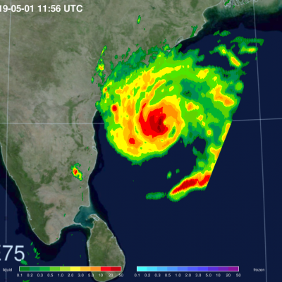
Satellite data revealed heavy rainfall in powerful Tropical Cyclone Fani before it made landfall in northeastern India. Fani brought that soaking rain to the region and continues to drop heavy rainfall on May 3, as it moves toward Bangladesh. NASA’s GPM or Global Precipitation Measurement mission satellite provides information on precipitation from its orbit in space. On May 1 at 7:56 a.m. EDT (1156 UTC), the GPM Core Observatory captured an overpass of the powerful storm as it continued strengthening and moving toward landfall. A 3D image and a color-enhanced rainfall image were created at
A diagram showing satellites in the GPM constellation orbiting Earth.
Co-led by NASA and the Japan Aerospace and Exploration Agency (JAXA), the Tropical Rainfall Measurement Mission (TRMM) and Global Precipitation Measurement (GPM) mission have built unprecedented international cooperation in space asset sharing and scientific collaboration to advance precipitation estimation from space for research and applications. GPM is an international satellite mission specifically designed to unify and advance precipitation measurements from research and operational microwave sensors for delivering next-generation global precipitation data products. The GPM mission
GPM flying over Earth with a data swath visualized.
The National Aeronautics and Space Administration (NASA), Science Mission Directorate, Earth Science Division has selected new projects from the 2018 Precipitation Measurement Missions (PMM) Science Team focus area solicitation. PMM projects focus on investigations related to satellite observations of precipitation using measurements from, but not limited to, the Global Precipitation Measurement (GPM) Core Observatory, GPM mission constellation partner spacecraft, and the Tropical Rainfall Measuring Mission (TRMM). Specifically the PMM program supports three types of investigations: (1) The...
5 Years of Global Precipitation Measurement
Download this video in high resolution from the NASA Goddard Scientific Visualization Studio Five years ago, on Feb. 27, 2014, the Global Precipitation Measurement (GPM) Core Observatory, a joint satellite project by NASA and the Japan Aerospace Exploration Agency (JAXA), lifted off aboard a Japanese H-IIA rocket. Since then, the cutting-edge instruments on GPM have provided advanced measurements about the rain and snow particles within clouds, Earth’s precipitation patterns, extreme weather and myriad ways precipitation around the world affects society. Among the uses of GPM data are helping...