Science

2022 PMM Science Team Meeting Group Photo
IMERG Sees a Dry September
Rainfall was scarce across much of the country in the month of September, pushing the eastern and southern thirds of the country into drought conditions. IMERG, the Integrated Multi-satellitE Retrievals for GPM, is a unified satellite precipitation product produced by NASA to estimate surface precipitation over most of the globe.
Observing the Intertropical Convergence Zone with IMERG
The intertropical convergence zone or “ITCZ” roughly forms a band that circumnavigates the Earth near the Equator where the northeast trade winds in the Northern Hemisphere converge with the southeast trade winds in the Southern Hemisphere. Sailors have often referred to it as the “doldrums” due to its generally light winds. Yet, the ITCZ is an important part of the global circulation as it forms the ascending branch of the Hadley circulation. This is ultimately driven by incoming solar radiation, which peaks near the Equator. This warms the air and the ocean, causing warm buoyant air to rise...
How TRMM and GPM Study Latent Heating
Latent heating (LH) arises predominantly from the release of heat associated with the condensation of water vapor into cloud droplets in clouds with active updrafts. Other sources of LH include ice deposition and freezing, while evaporation, melting and sublimation induce cooling, but condensation is the dominant heating term. Like a hot-air balloon, LH can keep air parcels warmer than their surrounding environment and therefore rising. On a large scale, LH is responsible for driving the ascending branch of the Hadley Circulation. LH is also an important component in the dynamics of a regional...
TMPA Shows El Niño Conditions in the Pacific
An El Niño that began to form last fall has matured and is now fully entrenched across the Pacific. Changes in sea surface temperatures, or SSTs, brought about by an El Niño affect the atmosphere, resulting in distinctive changes in the rainfall pattern across the Pacific Basin. These changes show up as anomalies or deviations in NASA’s analysis of climatological rainfall. This map shows sea surface temperature (SST) anomalies for the Pacific Basin, shown as degrees Celsius above or below average. Credit: NOAA Climate Prediction Center. In a typical El Niño, warmer than average SSTs off of the...
Finding Strong Storms with TRMM & GPM
Spring is severe storms season here in the US, but not everyone has NEXRAD radar coverage; however, NASA’s TRMM and GPM satellites with their onboard radars have made it possible to search the entire global Tropics and midlatitudes and systematically identify areas where there are strong to intense thunderstorms. Researchers now headed by Dr. Chuntao Liu at Texas A&M University have built a comprehensive database of “precipitation features” based on regions of contiguous radar echoes from first the TRMM and now the GPM satellite. These precipitation features can then be mined to locate areas...
Top 5 GPM Research Highlights
GPM celebrates its fifth anniversary since launching from Tanegashima Island, Japan on February 27, 2014. This milestone not only marks the launch but also the many scientific research accomplishments that GPM has made in advancing our understanding of precipitation, from light rain to intense thunderstorms, to further our understanding of the water cycle. Here are five of GPM’s most significant research accomplishments and their contributions to weather and climate science in its first five years in space: Snowfall and Cold Season Precipitation An image of GPM’s DPR concept of dual-frequency...
PMM Science Banner
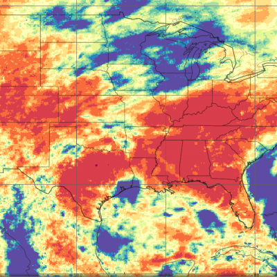
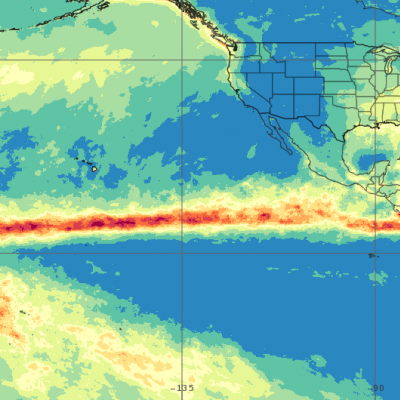
Water is fundamental to life on Earth, affecting the behavior of the weather, climate, energy and ecological systems as water moves through the Earth’s water cycle as vapor, liquid and ice. Precipitation, a key component of the water cycle, is difficult to measure since rain and snow vary greatly in both space and time. Obtaining reliable ground-based measurements of rain and snow often presents a formidable challenge due to large gaps between reliable instruments over land and, particularly, over the oceans. From the vantage point of space, satellites provide more frequent and accurate observations and measurements of rain and snow around the globe. This allows key insights into when, where and how much it rains or snows globally, supplying vital information to unravel the complex roles water plays in Earth systems.
GPM Gets Flake-y
In this video GPM Project Scientist Dr. Gail Skofronick-Jackson explains how scientists can measure the size, shape and distribution of snow particles, layer by layer, in a storm using GPM. The Global Precipitation Measurement mission is an international satellite project that provides next-generation observations of rain and snow worldwide every three hours.
GPM Sees Larsen-C Ice Shelf Separation
Click here to download the video (.mp4) On July 12, 2017, a giant iceberg broke off Antarctica and a variety of satellites have been used to study it ever since. The Global Precipitation Measurement (GPM) Microwave Imager (GMI) instrument can see the ribbon of relatively warm water and ice that separates the newly formed iceberg from the its parent mass of ice, the Larsen C ice shelf. While the iceberg is separated from the parent iceshelf by only a few kilometers, the GMI instrument is sensitive enough to detect the variation in temperature between this relatively warm gap and the colder ice...