Wildfires

Wildfires play an integral role in maintaining ecosystem biodiversity and structure.  Wildfires, which include any non-structure fire that occurs in vegetation or natural fuels, is an essential process that connects terrestrial systems to the atmosphere and climate. 

World Resources Institute Ethiopia
NASA’s Earth observation data are used in a wide variety of ways to improve life for humans and other animals across the world every day. Our climate is changing, and these changes include differences in temperature and precipitation patterns around the globe. As you might imagine, these changes bring about both anticipated and unanticipated consequences that have a profound impact on people around the world. Many organizations are responding to the amazing yet complicated wealth of data that can be used to successfully monitor many aspects of our global environment. The World Resources
Alaska Rainfall 2019 and 2020
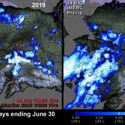
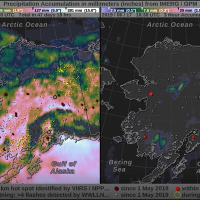
NASA's multi-satellite precipitation algorithm, known as IMERG , is a tool that can help us understand recent fluctuations in Alaska's wildfires. In the summer of 2020, wildfires burned fewer acres in Alaska than in any other year during the past 10 years. In contrast, wildfires burned a record number of acres in Alaska in the summer of 2019. The image below shows the locations of satellite-detected fires and precipitation during the last two weeks of June for both years. The above image shows IMERG rainfall totals overlaid with fire hot spot detections from the Visible Infrared Imaging
Rain Brought Brief Relief to Australia
For much of the 2019-2020 austral summer, plumes of bushfire smoke have billowed from southeastern Australia in such large amounts that the ground was barely visible in satellite images. In mid-January, some of those plumes were finally quelled by a few days of much-needed rainfall.
Rain Patterns During the Alaska Wildfires
NASA's satellite-based estimate of global precipitation can provide valuable information to officials monitoring the many wildfires in Alaska this summer. Wildfires occur in Alaska each summer, but July 2019 is shaping up to be a particularly active month. Few rain gauges exist in the large tracts of Alaskan wilderness, but wildfires unchecked can spread to populated areas within the state. Satellite-based precipitation estimates are particularly valuable here because of precipitation's relationship to wildfire hazard. The movie shows NASA's IMERG precipitation estimates for May 1 through July...
NASA Rainfall Data and Global Fire Weather
The Global Fire WEather Database (GFWED) integrates different weather factors influencing the likelihood of a vegetation fire starting and spreading. It is based on the Fire Weather Index (FWI) System, which tracks the dryness of three general fuel classes, and the potential behavior of a fire if it were to start. Each day, FWI values are calculated from global weather data, including satellite rainfall data from the Global Precipitation Measurement (GPM) mission.