First 2015 Tropical Storm Forms In Eastern Pacific
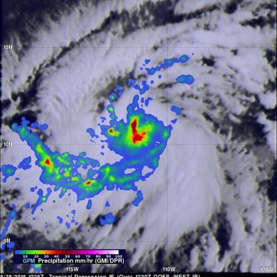
Tropical storm Andres became the first tropical storm of the the 2015 Eastern Pacific hurricane season today at 1500 UTC (9 AM MDT). The GPM core observatory satellite flew over the intensifying tropical cyclone (TD1E) at 1225 UTC ( 6:25 AM MDT). Rainfall data from GPM's Microwave Imager (GMI) and Dual-Frequency Precipitation Radar (Ku Band) instruments are shown overlaid on an enhanced GOES-EAST satellite infrared image received at 1230 UTC (6:30 AM MDT). Rain was found by GMI to be falling at a rate of over 60 mm (2.4 inches) per hour in powerful convective storms near Andres' center. Data