GPM Measures Tropical Storm Champi's Heavy Rainfall
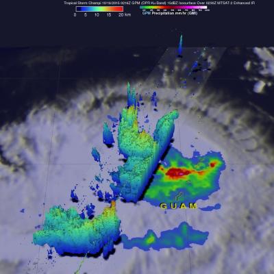
On October 16, 2015 at 0216 UTC the GPM core observatory satellite passed above tropical storm Champi as it was drenching the northern Mariana Islands. GPM's Dual-Frequency Precipitation Radar (DPR) measured rain within Champi falling at a rate of over 114.8 mm (4.5 inches) per hour in a band of intense showers. GPM's radar sliced through Champi's western side and made 3-D measurements of storm top heights. Radar reflectivity values found to be greater than 15 dBZ are shown in a simulated perspective 3-D view. The lowest Heights are shaded blue and the tallest 3-D 15dBZ surfaces are colored