Extreme Weather News

Jump to a Year

2022 | 2021 | 2020 | 2019 | 2018

2017 | 2016 | 2015 | 2014 | 2013

2012 | 2011 | 2010 | 2009 | 2008

2007 | 2006 | 2005 | 2004 | 2003

2002

Tropical Depression Kilo May Be A Problem For Hawaii

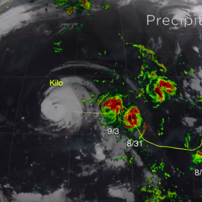
A tropical depression labeled Kilo formed to the southeast of the Hawaiian Islands on August 20, 2015. The tropical cyclone has moved to the southwest of the Islands. The Central Pacific Hurricane Center (CPHC) predicts that Kilo will strengthen into a hurricane as it moves in the general direction of the island of Kauai over the next five days. The GPM core observatory satellite measured the rainfall near Kilo on August 23, 2015 at 0131 UTC. GPM’s Microwave Imager (GMI) and GPM's Dual-Frequency Precipitation Radar (DPR) discovered that rain was falling at a rate of over 121 mm (4.8 inches)

Powerful Typhoon Goni Brushing The Philippines

Rain bands from typhoon Goni were hitting the island of Luzon in the northern Philippines when the GPM core observatory satellite flew over on August 20, 2015 at 0711 UTC (3:11 PM Philippine Standard Time). GPM's Microwave Imager (GMI) clearly showed the intensity of rain falling in Goni's inner and replacement outer eye wall. GMI found that precipitation was falling at a rate of over 88.0 (3.5 inches) in extreme rainfall south of Goni's distinct eye. Radar reflectivity data from GPM's Dual-Frequency Precipitation Radar (DPR) instrument was used in this view (from the east) to show the 3-D

Tropical Storm Danny Forms in the Atlantic

Tropical Storm Danny became the 4th named storm of the season yesterday afternoon when it formed in the central Atlantic about 1660 miles east of the Windward Islands. Danny originated from an African easterly wave that moved off of the coast of Africa 4 days earlier on the 14th of August. Storms that form in this region are known as Cape Verde storms and typically form towards the height of hurricane season. In a typical season, there are about 10 named storms and 6 hurricanes. With this year being a potentially strong El Nino year, Atlantic hurricanes are usually suppressed. However, it only

Intensifying Atsani Viewed By GPM

Atsani is a typhoon today but was an intensifying tropical storm moving over the open waters of the Pacific Ocean on August 16, 2015 when the GPM core observatory satellite flew above at 0601 UTC. An analysis of precipitation derived from GPM's Microwave Imager (GMI) and Dual-Frequency Precipitation Radar (DPR) instruments is shown overlaid on a 0600 UTC MTSAT-2 visible infrared image. This analysis revealed that very heavy rain that was located south of the storm's center of circulation. Rain there was found to be falling at a rate of over 90 mm (3.5 inches) per hour. A simulated 3-D view of

Another Typhoon Headed Toward Taiwan And China

Last week deadly typhoon Soudelor caused at least 22 deaths in Taiwan and China. The GPM core observatory satellite recently had two good views of intensifying typhoon Goni that formed on August 14, 2015 in the same area of the Pacific Ocean as typhoon Soudelor. Typhoon Goni is forecast by the Joint Typhoon Warning Center (JTWC) to become a very powerful typhoon in the next week while moving along a track similar to typhoon Soudelor. Typhoon Goni could affect the same areas of the western Pacific Ocean. The first image shows a GPM satellite pass over Goni when the tropical cyclone was moving