TRMM News

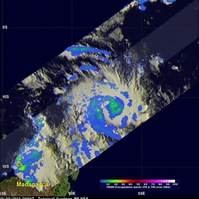
TRMM Sees More Powerful Bejisa

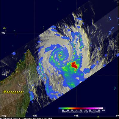
The TRMM satellite had an excellent view of intensifying tropical cyclone Bejisa northeast of Madagascar on December 31, 2013 at 0004 UTC. As expected, Bejisa became more powerful and had maximum sustained wind speeds estimated at 105 kts (~121 mph) when TRMM flew over. A rainfall analysis from TRMM's Microwave Imager (TMI) and Precipitation Radar (PR) instruments is shown overlaid on an enhanced infrared image from the Visible and InfraRed Scanner (VIRS). Extremely heavy rainfall in Bejisa's eye wall returned reflectivity values greater than 55dBZ to the Precipitation Radar (PR) instrument

Tropical Cyclone Bejisa Near Madagascar

A tropical cyclone called Bejisa formed in the South Indian Ocean north-northeast of Madagascar on December 29, 2013 . The TRMM satellite flew over on December 30, 2013 at 0059 UTC. The image on the left shows a TRMM rainfall analysis for intensifying tropical cyclone Bejisa at that time when sustained winds were estimated to be greater than 60 kts (~69 mph). Data collected with TRMM's Microwave Imager (TMI) instrument provided better coverage of rainfall with this TRMM pass than the Precipitation Radar (PR) instrument that traveled to the northwest of Bejisa's center. The image on the right

Tropical Cyclone Christine

Tropical cyclone Christine was in the South Indian Ocean close to the northwestern coast of Australia when the TRMM satellite passed over on December 30, 2013 at 1113 UTC. TRMM's Microwave Imager (TMI) and precipitation Radar (PR) instruments revealed that Christine had a well defined eye. TRMM PR found that the most intense rain was falling at a rate of over 70mm/hr (~2.8 inches) in intense bands well to the east of Christine's eye. TRMM's Microwave Imager (TMI) instrument provided good coverage of Christine's eye while TRMM's Precipitation Radar (PR) had a good look at Christine's

Intensifying Tropical Cyclone Bruce

A powerful tropical cyclone called Bruce formed quickly after tropical cyclone Amara in the south Indian Ocean. Intensifying Tropical cyclone Bruce had winds of over 90kts (~103.5 mph) When the TRMM satellite passed over head on December 19, 2013 at 1800 UTC. A rainfall analysis from TRMM's Microwave Imager (TMI) and Precipitation Radar (PR) instruments is shown on the left overlaid on an enhanced infrared image from TRMM's Visible and InfraRed Scanner (VIRS). Bruce was found to have a well defined eye with rain falling at a rate of over 115 mm/hr (~4.5 inches). TRMM PR sliced through the

TRMM Sees Tropical Cyclone Amara Forming

Yesterday Amara became the third tropical cyclone since October 2013 to form in the South Indian Ocean. TRMM Microwave Imager (TMI) and Precipitation Radar (PR) data captured by the TRMM satellite on December 16, 2013 at 2043 UTC were used in the image on the upper left. TRMM's Microwave Imager (TMI) and Precipitation Radar (PR) instruments showed that Amara was getting organized with scattered bands of moderate to heavy rain spiraling into the tropical cyclone's center. TRMM PR located some strong radar reflectivity values of over 47.7 dBZ in rain falling at a rate of over 76.9 mm/hr (~3

TRMM Sees Powerful Storms In Tropical Cyclone Madi

The TRMM satellite flew over tropical cyclone Madi in the Bay Of Bengal on December 11, 2013 at 1034 UTC. TRMM's Microwave Imager (TMI) and Precipitation Radar (PR) instruments found that Madi contained powerful storms southeast of Madi'a center of circulation dropping rain at the rate of over 81 mm/hr (~3.2 inches). An analysis of Madi's 3-D vertical structure using TRMM PR found that tops of these convective towers were reaching extremely high altitudes greater than 19km(~11.8 miles). Tropical cyclone Madi is predicted by the Joint Typhoon Warning Center (JTWC) to weaken while moving over

Philippine's Tropical Cyclone Rainfall 2013

In a normal year 30% of the total rainfall near the Philippines (northwestern Pacific Ocean) is caused by tropical cyclones. The most notable tropical cyclone this year was deadly super typhoon HAIYAN that devastated the central Philippines in November 2013. The TRMM-based, near-real time Multi-satellite Precipitation Analysis (TMPA) at the NASA Goddard Space Flight Center was used to analyze only rainfall near tropical cyclones passing close to or over the the Philippines in 2013. The TMPA analysis above shows the estimated total rainfall contributed by named tropical cyclones this year. Red

Tropical Cyclone Alessia Soaks Northern Australia

During the past weekend tropical cyclone ALESSIA weakened to a tropical low as it moved from the Timor Sea over Northern Australia. The warm waters of the Gulf Of Capentaria have helped revive ALESSIA to tropical storm intensity today. The image on the right shows TRMM satellite data collected on November 27, 2013 at 0225 UTC. A 3-D perspective view (from the west) shows the tropical cyclone's vertical structure based on radar reflectivity data collected by TRMM's Precipitation Radar (PR) instrument. Thunderstorm towers are shown reaching heights above 16km (~9.92 miles) in a feeder band east

Tropical Cyclone Lehar Moving Toward India

Tropical cyclone LEHAR, located in the Bay Of Bengal, continues to gain intensity while heading toward the same area of India where a much weaker tropical cyclone HELEN recently came ashore. The Joint Typhoon Warning Center (JTWC) predicts that LEHAR's sustained wind speeds will reach 95 kts (~109 mph) on November 27, 2013 and then decrease to about 85 kts (~98 mph) before hitting India's east-central coast. The TRMM satellite flew above tropical cyclone LEHAR on November 26, 2013 at 0307 UTC and captured data used in the image above. Rainfall derived from TRMM's Microwave Imager (TMI) and

Tropical Cyclone Lehar In The Bay Of Bengal

Today tropical cyclone LEHAR's estimated sustained wind speeds reached 65kts (~75 mph). The most powerful tropical cyclone in the Bay Of Bengal this year was deadly tropical cyclone PHAILIN that moved through the area in October with wind speeds of 140kts (~161 mph). This means that LEHAR is the second most powerful tropical cyclone to form in the Bay Of Bengal this year. The TRMM satellite collected data used in the image on the left when the TRMM satellite passed above LEHAR on November 24, 2013 at 1812 UTC. At that time LEHAR was intensifying with tropical storm force winds estimated to be