TRMM News

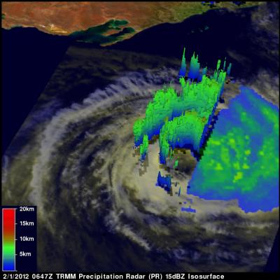
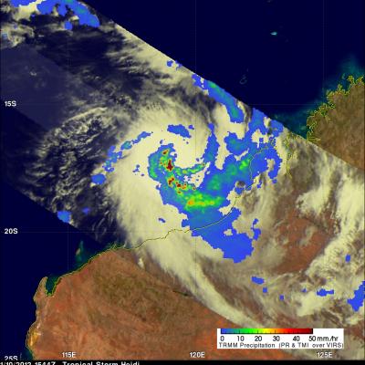
Iggy Rainfall Hits Australia

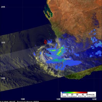
On 2 February 2012 at 1044 UTC the TRMM satellite again saw weakening tropical storm IGGY as it was approaching the coast of southwestern Australia. Data from TRMM's Microwave Imager (TMI) and Precipitation Radar (PR) instruments showed that bands of heavy rainfall measuring over 50mm/hr (~2 inches) were hitting coastal areas northwest of Perth, Australia. A red tropical storm symbol shows where Iggy's center was located.

Tropical Cyclone Iggy

The TRMM satellite passed above tropical storm Iggy on 1 February 2012 at 0647 UTC as the storm was heading toward the coast of southwestern Australia. Iggy was briefly categorized as a category 1 tropical cyclone on the Saffir-Simpson scale but is predicted to be a weak tropical storm with winds of about 35kts (~40 mph) when it moves over the Australian coast. Iggy's past and forecast locations are shown with appropriate white tropical cyclone symbols on the image above. TRMM data revealed that Iggy had a large area of moderate to heavy rainfall south of the center of circulation. TRMM's

Tropical Cyclone Funso

The TRMM satellite saw directly into the eye of tropical Cyclone Funso on 26 January 2012 at 2013 UTC. TRMM Microwave Imager (TMI) and Precipitation Radar (PR) rainfall shows that frequent moderate to heavy rainfall was located in bands around Funso. TRMM PR data show that the tallest storm towers , reaching to about 12km (~7.5 miles), were located in a feeder band southwest of the eye.

Monsoon brings Heavy Rain to Parts of Australia

Thousands of people were asked to evacuate recently as parts of northern and eastern Australia felt the effects of heavy rains brought about by the summer monsoon. Though not expected to be as bad as last year, when dozens of people were killed and tens of thousands of homes were flooded, the recent heavy rains have led to flash flooding and landslides in Queensland and caused rivers to overflow their banks in New South Wales. The monsoon plays a prominent role in the annual rainfall cycle over Australia. A monsoon is a seasonal phenomenon wherein an area of low pressure forms over a large

TRMM sees Powerful Tropical Cyclone Funso

The TRMM satellite had a good view of powerful tropical cyclone Funso battering the Mozambique coast when it flew over on 23 January 2012 at 1451 UTC. TRMM data shows that Funso was dropping moderate to heavy rainfall in bands covering the Mozambique channel from eastern Mozambique to western Madagascar. Storms and floods from Funso have killed at least 22 people and forced tens of thousands from their homes in Mozambique. Tropical cyclone Funso formed in the Mozambique channel off the coast of Mozambique on 19 January 2012. The image above shows what TRMM saw on 21 January 2012 when Funso had

TRMM Sees Tropical Storm Heidi

On 10 January 2012 at 1544 UTC the TRMM satellite passed above tropical storm Heidi as it was forming off the northwestern coast of Australia. Heidi is the first named tropical cyclone to hit Australia this season. An analysis of rainfall from TRMM Microwave Imager (TMI) and Precipitation Radar (PR) data is shown above. This analysis shows that Heidi was starting to get organized with bands of heavy convective rainfall spiraling toward the center of the storm. Heidi was dropping rainfall at a rate of over 50mm/hr (~2 inches) in some areas. A 3-D image above was made from TRMM PR data. It shows

TRMM Sees Tropical Storm Striking Madagascar

The TRMM satellite has been collecting data that improves understanding of rainfall in the tropics since it's launch in 1997. The satellite also provides timely data about the development of tropical cyclones. One of these tropical cyclones called Chanda was hitting the coast of Madagascar when TRMM saw it on 8 January 2012 at 2213 UTC. A red tropical storm symbol is shown at Chandra's approximate location. Data from TRMM's Precipitation Radar (PR) and Microwave Imager (TMI) instruments shows that Chanda was dropping light to moderate rainfall over large areas of southern Madagascar. Deadly

Flooding Hits Southeastern Brazil

In the last week the South American Convergence Zone (SACZ) has caused heavy rains and severe floods in Southeastern Brazil's states Minas Gerais, Espirito Santo and Rio de Janeiro. NOAA's Hydrological Prediction Center (HPC) is forecasting an intensification of the SACZ in the next days over that area. Flooding and mudslides from days of heavy rain in southeastern Brazil has forced thousands to flee their homes. Rainfall estimates from the TRMM-based, near-real time Multi-satellite Precipitation Analysis (TMPA) at the NASA Goddard Space Flight Center are shown above for the week from 30

Tropical Cyclone Thane Hits India

At least 33 people were killed when tropical cyclone Thane with reported winds of up to 85 mph hit the southeastern coast of India Friday morning. The TRMM satellite saw the tropical cyclone several times from it's birth in the Bay of Bengal to it's strengthening to hurricane force before penetrating the Indian coast. Thane was a tropical storm with winds of about 40kts when TRMM passed above on 26 December 2011 at 1305 UTC. The storm was starting to organize with TRMM Precipitation Radar (PR) revealing a large area of powerful storms surrounding the northern side. A TRMM Microwave Imager (TMI

Philippines Devastated by Tropical Storm Washi

Washi, known locally in the Philippines as Sendong, began as a tropical depression on the 13th of December 2011 in the West Pacific Ocean about 2150 km (~1333 miles) due east of the southern Philippines. Washi only intensified slightly and never exceeded tropical storm intensity as it tracked due west towards the southern Philippines' island of Mindanao. Washi made landfall on the east coast of Mindanao on the afternoon of the 16th as a moderate tropical storm with sustained winds reported at 55 knots (~63 mph). Despite its modest intensity, Washi had a huge impact on the island. As Washi made