TRMM News

TRMM Sees Typhoon Songda

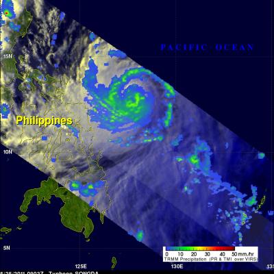
Typhoon Songda was east of the Philippines when the TRMM satellite had an early evening view on 25 May 2011 at 0903 UTC. Both TRMM's Microwave Imager (TMI) and Precipitation Radar (PR) instruments were used to provide the rainfall analysis shown above. TRMM's TMI had the best coverage of rainfall with Songda and showed well organized bands of moderate to heavy rainfall converging into the typhoon. Songda was an intensifying category 3 typhoon, on the Saffir-Simpson scale, with wind speeds of over 105 kts (~121 mph) at that time. Songda is predicted to become a very powerful category 4 super

Tropical Storm Four Forms in the Pacific

The TRMM satellite flew over rapidly forming TS04W in the western Pacific on 20 May 2011 at 0037 UTC (~10:37 AM LOCAL TIME). This daylight TRMM pass showed that the tropical cyclone was becoming much better organized. The intensifying tropical cyclone now contained several areas of heavy thunderstorms dropping rain at over 50 mm/hour (~2 inches/hour). The 3-D perspective image on the upper right shows the storm's vertical structure. TRMM's Precipitation Radar (PR) now showed that some thunderstorm towers near the center of circulation were punching up to heights of over 16 km (~9.9 miles)

Deadly Tropical Storm Hits the Philippenes

Tropical storm AERE was the first tropical cyclone to hit the Philippines in 2011 and was responsible for the deaths of least 22 people. AERE, also known as Bebeng in the Philippines islands, formed east of the Philippines on 6 May 2011. Data collected by the TRMM satellite on 8 May 2011 at 0823 UTC (~4:23 PM LOCAL) were used in the image on the left above. At that time AERE had wind speeds estimated at about 50 knots (~58 mph). TRMM Precipitation Radar data from this orbit were used in the image on the upper right to show the 3-D vertical structure within AERE. Some thunderstorms within AERE

2011 a Wet Spring for the Central US

A combination of heavy rains and a large snow melt has put parts of the central US at risk for record flooding this spring with several locations along the Mississippi already at or near record levels. One likely culprit is La Nina. Despite the fact that the current La Nina appears to be winding down, it's effects in the atmosphere can persist for a while. Furthermore, although not every La Nina brings major flooding to the region, La Nina's are conducive for above-normal rainfall from East Texas and northern Louisiana up through Arkansas and the Tennessee and Ohio Valleys with below-normal

Tropical Cyclones over Australia

TRMM-based, near-real time Multi-satellite Precipitation Analysis (TMPA), data were used in the analysis above to show rainfall contributed by tropical cyclones that have affected Australia in 2011. The tracks of tropical cyclones are shown with thin black lines. The largest tropical cyclone rainfall contribution was over the coast of northwestern Australia with estimated totals of over 600 Millimeters (~23.6 inches). Cyclones Bianca, Carlos, Twenty, Errol and their remnants were close enough to the northwestern coast of Australia to add to these rainfall totals. Cyclones Zelia, Anthony and

Tropical Cyclone Errol Near Australia

The South Indian Ocean tropical cyclone season is nearing it's end but another tropical cyclone called ERROL has developed northwest of Australia. The TRMM satellite flew over ERROL when it was getting organized on 14 April 2011 at 1732 UTC. The image on the left above shows an analysis of rainfall using data from TRMM's Microwave Imager (TMI) and Precipitation Radar (PR) instruments. The light swath shows the locations of some heavy thunderstorms as TRMM's PR crossed over ERROL's center of circulation. The image on the upper right shows a 3-D image of these thunderstorms made from those radar

TRMM Examines Another Potential Tropical Cyclone

The Tropical Rainfall Measuring Mission (TRMM) satellite was placed into its low-earth orbit in November of 1997. Its primary mission has been to measure rainfall from space. TRMM has provided space borne rain radar and microwave radiometric data that measure the vertical and horizontal distribution of rainfall over the tropics. It has also been valuable for monitoring the development of tropical cyclones, especially over remote parts of the open ocean. The image on the right uses data captured by the TRMM satellite on 7 April 2011 at 1914 UTC. It shows a TRMM satellite view of rain intensity

TRMM Sees Deadly Rainfall over Thailand

More than 15 people have been killed in Thailand over the past week due to flooding and mudslides caused by extremely heavy rainfall. The Multisatellite Precipitation Analysis (TMPA) analysis above was made using data that were calibrated with TRMM precipitation data. These data are calculated and stored at NASA Goddard Space Flight center and are available within a few hours after being received by satellites. This analysis shows that rainfall for the past week over the Malay Peninsula was particularly extreme with totals of almost 1200 mm (~47 inches). TRMM satellite data revealed that